
-
Federal
Global Fire Emissions Database, Version 4.1 (GFEDv4) NGDA 11 recent views
National Aeronautics and Space Administration —
This dataset provides global estimates of monthly burned area, monthly emissions and fractional contributions of different fire types, daily or 3-hourly fields to... -
Federal
CALIPSO Lidar Level 2 Cloud Profile, V4-20
National Aeronautics and Space Administration —
CAL_LID_L2_05kmCPro-Standard-V4-20 is the Cloud-Aerosol Lidar and Infrared Pathfinder Satellite Observations (CALIPSO) Lidar Level 2 Cloud Profile, Version 4-20 data... -
Federal
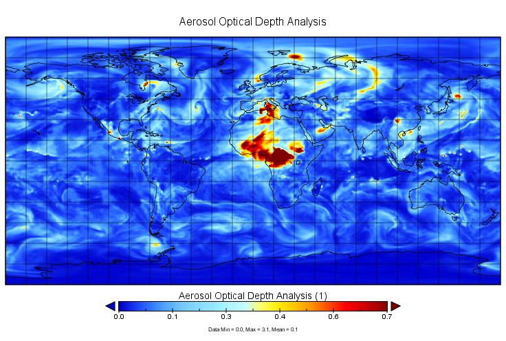
MERRA-2 inst3_2d_gas_Nx: 2d,3-Hourly,Instantaneous,Single-Level,Assimilation,Aerosol Optical Depth Analysis 0.625 x 0.5 degree V5.12.4 (M2I3NXGAS) at GES DISC
National Aeronautics and Space Administration —
M2I3NXGAS (or inst3_3d_gas_Nx) is an instantaneous 2-dimensional 3-hourly data collection in Modern-Era Retrospective analysis for Research and Applications version 2... -
Federal
Moderate Resolution Imaging Spectroradiometer (MODIS) - Terra NGDA
National Aeronautics and Space Administration —
This dataset represents multiple products archived at the multiple archive centers for the MODIS (Moderate Resolution Imaging Spectroradiometer) instrument aboard the... -
Federal
MODIS/Terra+Aqua L3 Value-added Aerosol Optical Depth - NRT NGDA
National Aeronautics and Space Administration —
MODIS was launched aboard the Terra satellite on December 18, 1999 (10:30 am equator crossing time) as part of NASA's Earth Observing System (EOS) mission. MODIS with... -
Federal
AERONET Level 2.0 AOD
National Aeronautics and Space Administration —
The aerosol optical depth processing includes the spectral de-convolution algorithm (SDA) described in O'Neill et al. (2003). This algorithm yields fine (sub-micron)... -
Federal
CATS-ISS Level 2 Operational Day Mode 7.2 Version 3-00 5 km Layer
National Aeronautics and Space Administration —
CATS-ISS_L2O_D-M7.2-V3-00_05kmLay is the Cloud-Aerosol Transport System (CATS) International Space Station (ISS) Level 2 Operational Day Mode 7.2 Version 3-00 5 km... -
Federal
NARSTO EPA Supersite (SS) Houston, Texas Air Quality Study 2000 (TexAQS2000) Department of Energy (DOE) G-1 Air Chemistry, Aerosol, and Met Data
National Aeronautics and Space Administration —
NARSTO_EPA_SS_HOUSTON_TEXAQS2000_DOE_G-1_DATA is North American Research Strategy for Tropospheric Ozone (NARSTO) Environmental Protection Agency (EPA) Supersite (SS)... -
Federal
CATS-ISS Level 1B Day Mode 7.1 Version 3-00
National Aeronautics and Space Administration —
CATS-ISS_L1B_D-M7.1-V3-00 is the Cloud-Aerosol Transport System (CATS) International Space Station (ISS) Level 1B Day Mode 7.1 Version 3-00 data product. The... -
Federal
Global Annual PM2.5 Grids from MODIS, MISR and SeaWiFS Aerosol Optical Depth (AOD), 1998-2019, V4.GL.03 NGDA
National Aeronautics and Space Administration —
The Global Annual PM2.5 Grids from MODIS, MISR and SeaWiFS Aerosol Optical Depth (AOD), 1998-2019, V4.GL.03 consists of annual concentrations (micrograms per cubic... -
Federal
MERRA-2 inst3_3d_aer_Nv: 3d,3-Hourly,Instantaneous,Model-Level,Assimilation,Aerosol Mixing Ratio 0.625 x 0.5 degree V5.12.4 (M2I3NVAER) at GES DISC
National Aeronautics and Space Administration —
M2I3NVAER (or inst3_3d_aer_Nv) is an instantaneous 3-dimensional 3-hourly data collection in Modern-Era Retrospective analysis for Research and Applications version 2... -
Federal
Daily and Annual PM2.5 Concentrations for the Contiguous United States, 1-km Grids, Version 1.10 (2000-2016)
National Aeronautics and Space Administration —
The Daily and Annual PM2.5 Concentrations for the Contiguous United States, 1-km Grids, Version 1.10 (2000-2016) data set includes predictions of PM2.5 concentration... -
Federal
CALIPSO Lidar Level 3 Tropospheric Aerosol Profiles, All Sky Data, Standard V4-20
National Aeronautics and Space Administration —
CAL_LID_L3_Tropospheric_APro_AllSky-Standard-V4-20 is the Cloud-Aerosol Lidar and Infrared Pathfinder Satellite Observation (CALIPSO) Lidar Level 3 Tropospheric... -
Federal
CALIPSO Lidar Level 1B profile data, V4-10
National Aeronautics and Space Administration —
CAL_LID_L1-Standard-V4-10 is the Cloud-Aerosol Lidar and Infrared Pathfinder Satellite Observation (CALIPSO) Lidar Level 1B profile data, Version 4-10 data product.... -
Federal
Daily and Annual PM2.5, O3, and NO2 Concentrations at ZIP Codes for the Contiguous U.S., 2000-2016, v1.0
National Aeronautics and Space Administration —
The Daily and Annual PM2.5, O3, and NO2 Concentrations at ZIP Codes for the Contiguous U.S., 2000-2016, v1.0 data set contains daily and annual concentration... -
Federal
CATS-ISS Level 2 Operational Night Mode 7.1 Version 3-01 5 km Layer
National Aeronautics and Space Administration —
CATS-ISS_L2O_N-M7.1-V3-01_05kmLay is the Cloud-Aerosol Transport System (CATS) International Space Station (ISS) Level 2 Operational Night Mode 7.1 Version 3-01 5 km... -
Federal
Mirador - Atmospheric Composition
National Aeronautics and Space Administration —
Earth Science data access made simple. Atmospheric Composition is focused on the composition of Earth's atmosphere in relation to climate prediction, solar effects,... -
Federal
MISR L2 Aerosol Product subset for the SAMUM region V002
National Aeronautics and Space Administration —
This is the Level 2 Aerosol Product.It contains Aerosol optical depth and particle type, with associated atmospheric data for the SAMUM_2006 theme. -
Federal
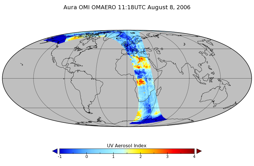
OMI/Aura Multi-wavelength Aerosol Optical Depth and Single Scattering Albedo 1-orbit L2 Swath 13x24 km V003 (OMAERO) at GES DISC
National Aeronautics and Space Administration —
The Level-2 Aura Ozone Monitoring Instrument (OMI) Aerosol Product (OMAERO) is now available from NASA Goddard Earth Sciences Data and Information Services Center...

Official websites use .gov
A
.gov website belongs to an official government
organization in the United States.
Secure .gov websites use HTTPS
A
lock (
) or https:// means you’ve safely connected to
the .gov website. Share sensitive information only on official,
secure websites.