
-
City
Austin Tree Canopy Map 2022 10 recent views
City of Austin —
This is a map depicting tree canopy in Austin, Texas summer of 2022. -
Federal
Daymet: Daily Surface Weather Data on a 1-km Grid for North America, Version 4 R1
National Aeronautics and Space Administration —
This dataset provides Daymet Version 4 R1 data as gridded estimates of daily weather parameters for North America, Hawaii, and Puerto Rico. Daymet variables include... -
Federal
Global Land Cover Mapping and Estimation Yearly 30 m V001
National Aeronautics and Space Administration —
NASA’s Making Earth System Data Records for Use in Research Environments (MEaSUREs) Global Land Cover Mapping and Estimation (GLanCE) annual 30 meter (m) Version 1... -
Federal
NACP Regional: National Greenhouse Gas Inventories and Aggregated Gridded Model Data
National Aeronautics and Space Administration —
This data set provides two products that were derived from the recently published North American Carbon Program (NACP) Regional Synthesis 1-degree terrestrial... -
Federal
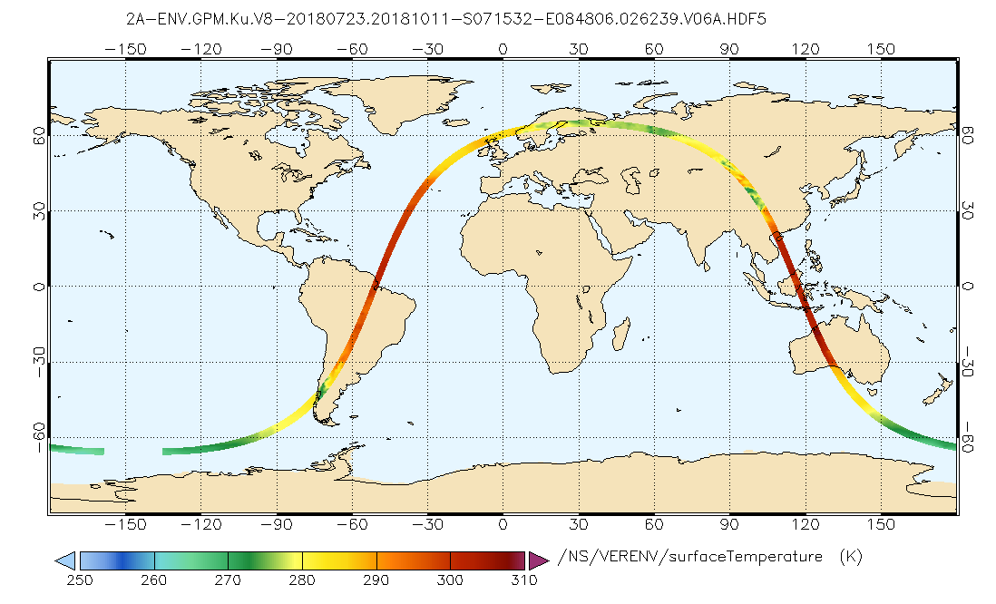
GPM DPR Ku Environment L2A 1.5 hours 5 km V07 (GPM_2AKuENV) at GES DISC
National Aeronautics and Space Administration —
Version 07 is the current version of the data set. Older versions will no longer be available and have been superseded by Version 07. . This is environmental data... -
Federal
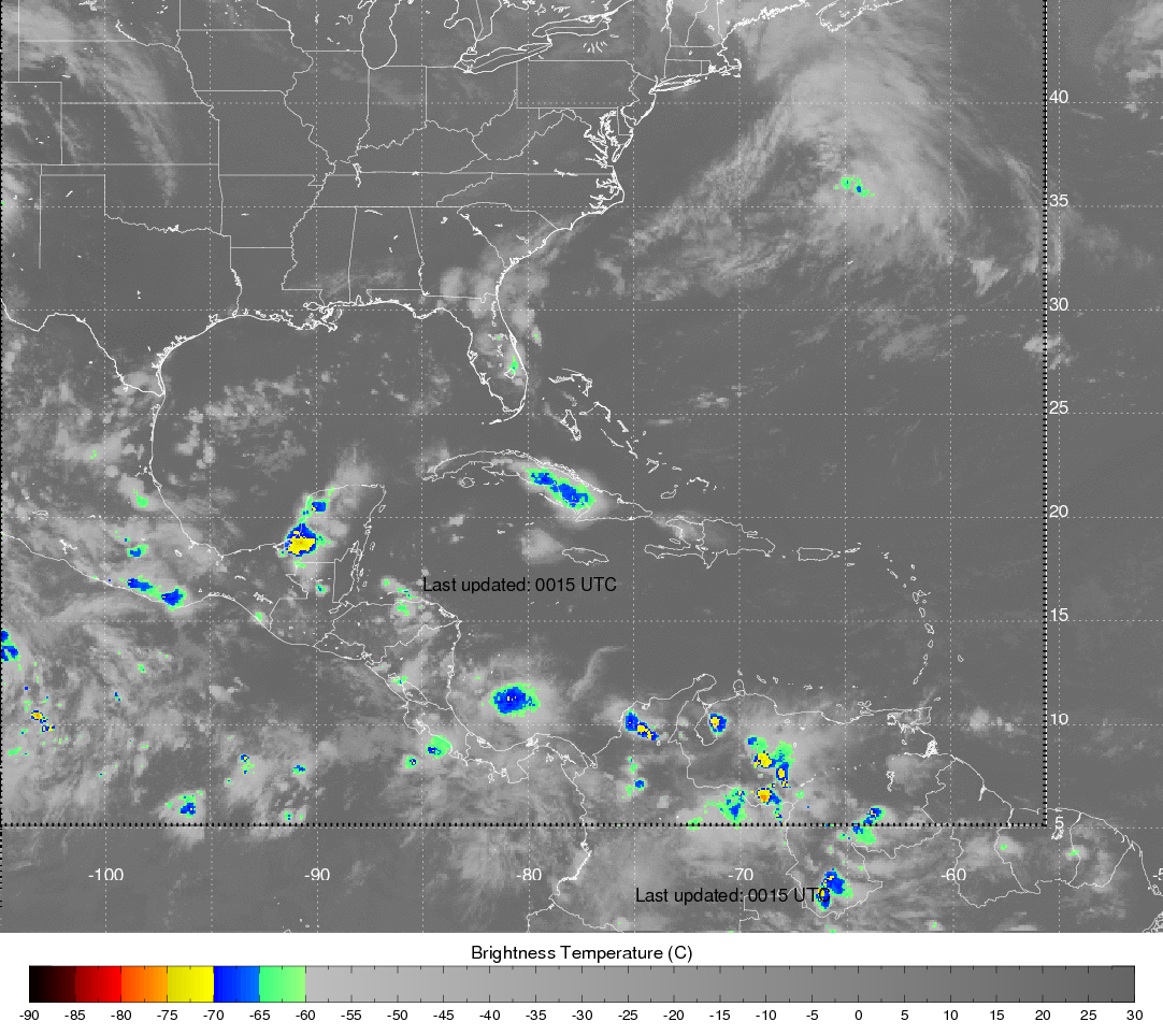
Hurricane and Severe Storm Sentinel (HS3) Cooperative Institute for Meteorological Satellite Studies (CIMSS) Brightness Temperature V1
National Aeronautics and Space Administration —
The Hurricane and Severe Storm Sentinel (HS3) Cooperative Institute for Meteorological Satellite Studies (CIMSS) Brightness Temperature dataset contains infrared... -
Federal
GPM GROUND VALIDATION NASA S-BAND DUAL POLARIMETRIC (NPOL) DOPPLER RADAR MC3E V1
National Aeronautics and Space Administration —
The GPM Ground Validation NASA S-band Dual Polarimetric (NPOL) Doppler Radar MC3E dataset was collected by the NASA NPOL radar, which was developed by a research team... -
Federal
DEEPEN 3D PFA Favorability Models and 2D Favorability Maps at Newberry Volcano
Department of Energy —
DEEPEN stands for DE-risking Exploration of geothermal Plays in magmatic ENvironments. Part of the DEEPEN project involved developing and testing a methodology for a... -
Federal
SAFARI 2000 MISR Level 2 Data, Southern Africa, Dry Season 2000
National Aeronautics and Space Administration —
MISR (Multi-angle Imaging SpectroRadiometer) views the sunlit Earth simultaneously at nine widely spaced and collects global images with high spatial detail in four... -
Federal
OMI/Aura NO2 Tropospheric, Stratospheric & Total Columns MINDS Daily L2 Global Gridded 0.25 degree x 0.25 degree V1.1 (OMI_MINDS_NO2G) at GES DISC
National Aeronautics and Space Administration —
As part of the NASA's Making Earth System Data Records for Use in Research Environments (MEaSUREs) program, this project entitled “Multi-Decadal Nitrogen Dioxide and... -
Federal
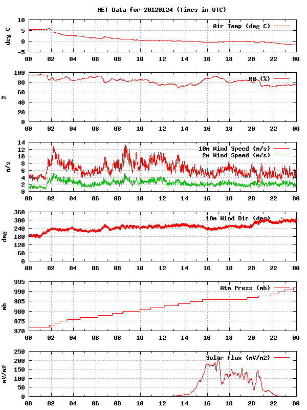
GPM GROUND VALIDATION METEOROLOGICAL TOWER ENVIRONMENT CANADA GCPEX V1
National Aeronautics and Space Administration —
The GPM Ground Validation Meteorological Tower Environment Canada GCPEx dataset provides temperature, relative humidity, 10 m winds, pressure and solar radiation data... -
Federal
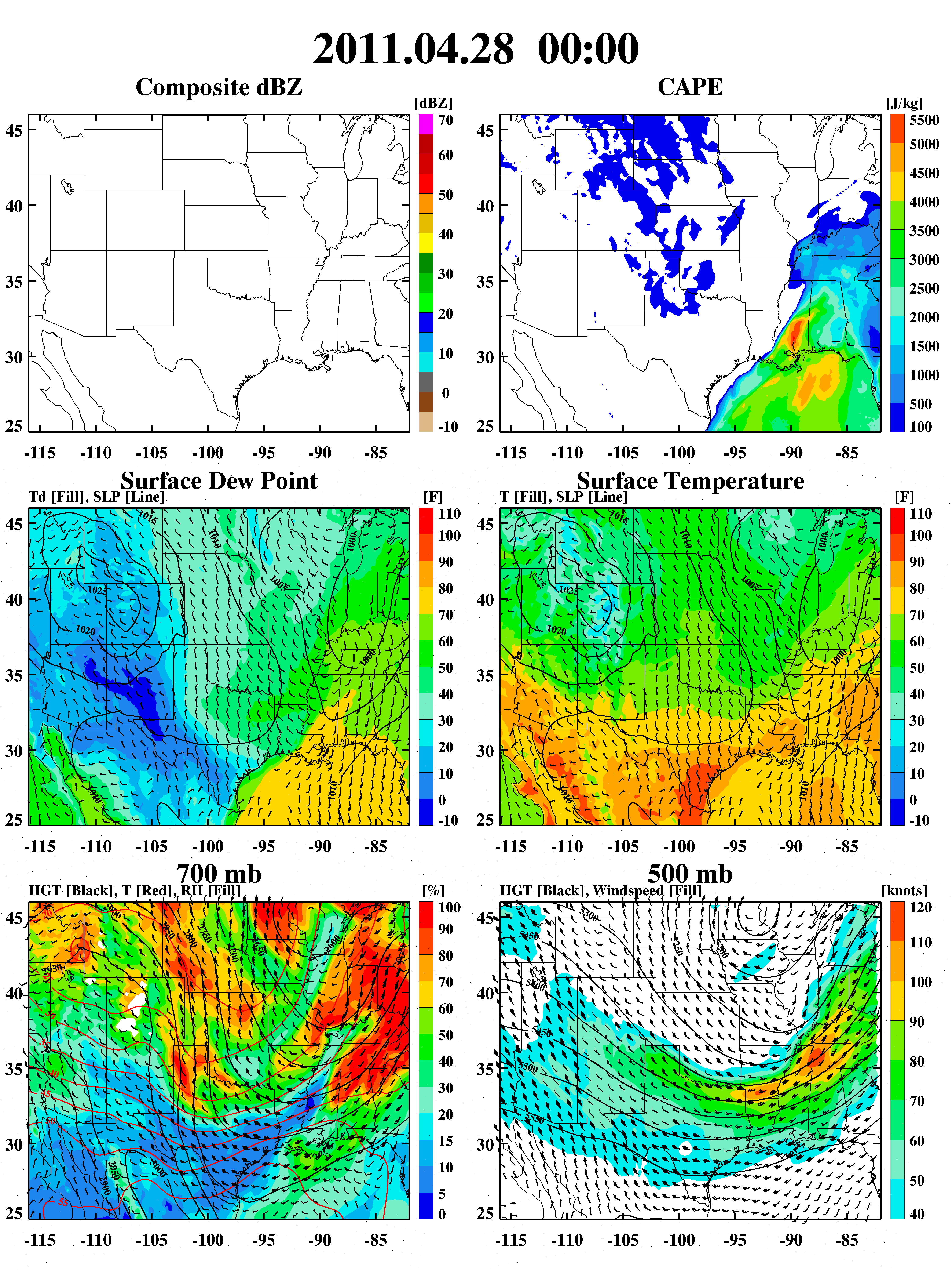
GPM Ground Validation Weather Research and Forecasting (WRF) Images MC3E V1
National Aeronautics and Space Administration —
The GPM Ground Validation Weather Research and Forecasting (WRF) Images MC3E dataset consists of browse only images showing radar reflectivity, radar echo top,... -
Federal
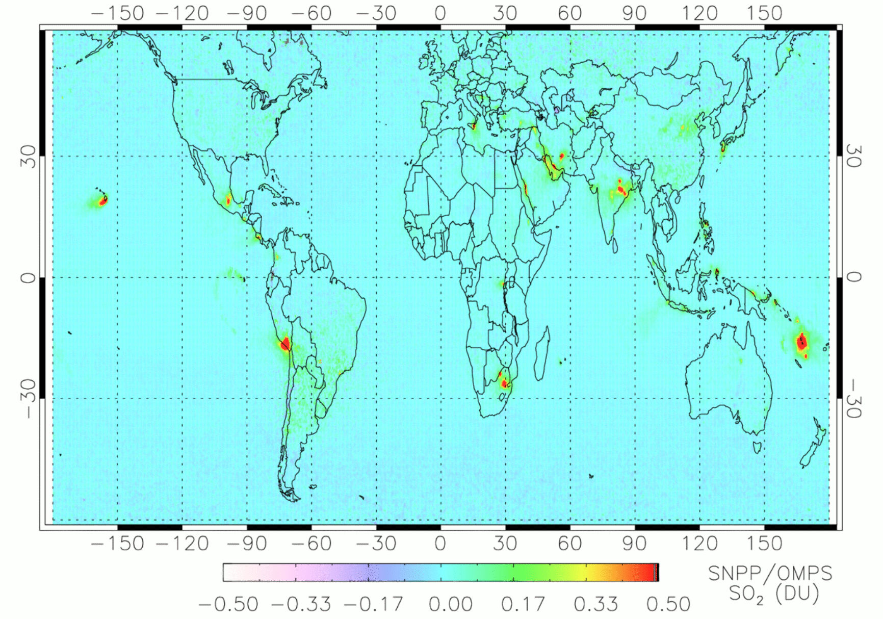
OMPS/NPP PCA SO2 Total Column 1-Orbit L2 Swath 50x50km V2 (OMPS_NPP_NMSO2_PCA_L2) at GES DISC
National Aeronautics and Space Administration —
The OMPS_NPP_NMSO2_PCA_L2 product is part of the MEaSUREs (Making Earth Science Data Records for Use in Research Environments) suite of products. It is retrieved from... -
Federal
UNH TDP - Concurrent Measurements of Inflow, Power Performance, and Loads for a Grid-Synchronized Vertical Axis Cross-Flow Turbine Operating in a Tidal Estuary
Department of Energy —
This data was collected between October 12 and December 15 of 2021 at the University of New Hampshire (UNH) and Atlantic Marine Energy Center (AMEC) turbine... -
Federal
UV-visible absorbance spectra of purified and unpurified m-cresol purple samples in sodium hydroxide and sodium chloride solutions at pH 12
National Institute of Standards and Technology —
M-cresol purple is the most widely used pH indicator dye for seawater pH measurements. Impurities in the indicator are known to absorb strongly at one of the... -
Federal
ISLSCP II Historical Land Cover and Land Use, 1700-1990 NGDA
National Aeronautics and Space Administration —
The Historical Land Cover and Land Use data set was developed to provide the global change community with historical land use estimates. The data set describes... -
Federal
USU Camas-1 Test Well: Documentation
Department of Energy —
This submission contains documents that describe the USU Camas-1 test well, drilled in Camas Prairie, Idaho, in Fall 2018 and Fall 2019. The purpose of this well is... -
Federal
BOREAS Follow-On DSP-09 Saskatchewan Raster Forest Fire Chronology, 1945-1996
National Aeronautics and Space Administration —
This data set contains a pair of raster images and a spreadsheet chronicling the most recent fire history of Saskatchewan from 1945 to 1996. This data set was... -
Federal
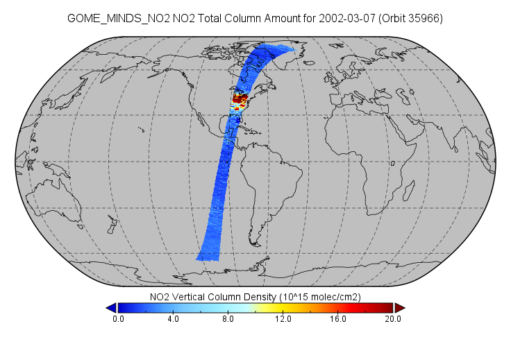
GOME/ERS-2 NO2 Tropospheric, Stratospheric and Total Columns MINDS 1-Orbit L2 Swath 40 km x 320 km V1.1 (GOME_MINDS_NO2) at GES DISC
National Aeronautics and Space Administration —
As part of the NASA's Making Earth System Data Records for Use in Research Environments (MEaSUREs) program, this project entitled “Multi-Decadal Nitrogen Dioxide and... -
Federal
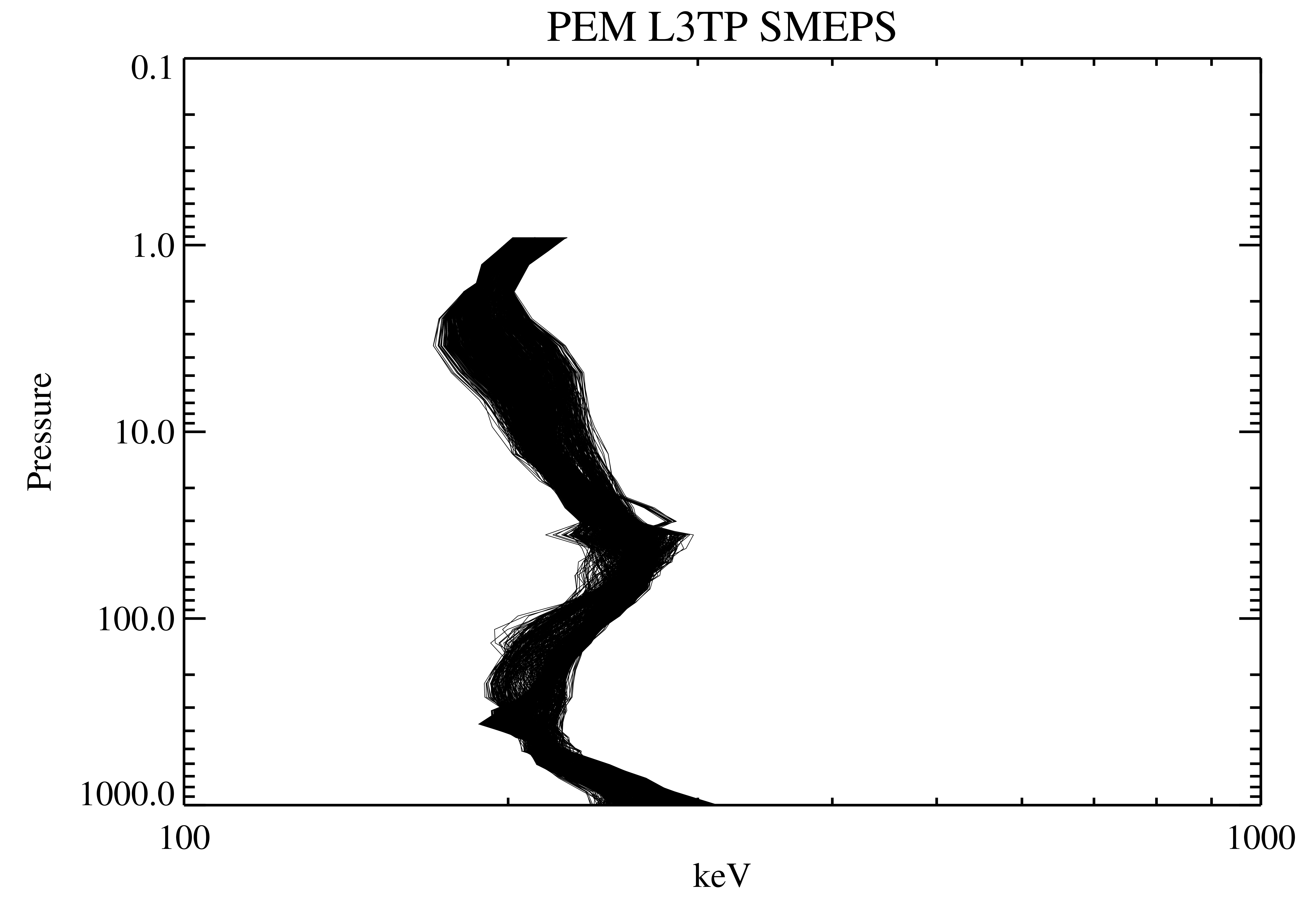
UARS PEM Level 2 AXIS 2 V001 (UARPE2AXIS2) at GES DISC
National Aeronautics and Space Administration —
The UARS Particle Environment Monitor (PEM) level 2 Atmosphere X-Ray Imaging Spectrometer (AXIS) unit 2 daily product contains the X-ray high-resolution spectral data...

Official websites use .gov
A
.gov website belongs to an official government
organization in the United States.
Secure .gov websites use HTTPS
A
lock (
) or https:// means you’ve safely connected to
the .gov website. Share sensitive information only on official,
secure websites.