
-
Federal
NOS CO-OPS Water Level Data, Preliminary, 1-Minute
National Oceanic and Atmospheric Administration, Department of Commerce —
This dataset has recent, preliminary (not quality-controlled), 1-minute, water level (tide) data from NOAA NOS Center for Operational Oceanographic Products and... -
Federal
Liquid Robotics Wave Glider, Honey Badger (G3), 2015, C3
National Oceanic and Atmospheric Administration, Department of Commerce —
Liquid Robotics Wave Glider, Honey Badger (G3), 2015, C3. C3 board number 8215 (not coated) appears as board_id=32, task_id=23. C3 board number 771 (coated) appears... -
Federal
The development and evaluation of small specialized turtle excluder devices to reduce sea turtle bycatch in small skimmer nets (NCEI Accession 0226612)
National Oceanic and Atmospheric Administration, Department of Commerce —
This dataset contains records of Gulf of Mexico (GOM) white shrimp (Litopenaeus setiferus), and brown shrimp (Farfantepenaeus aztecus), and bycatch (other... -
Federal
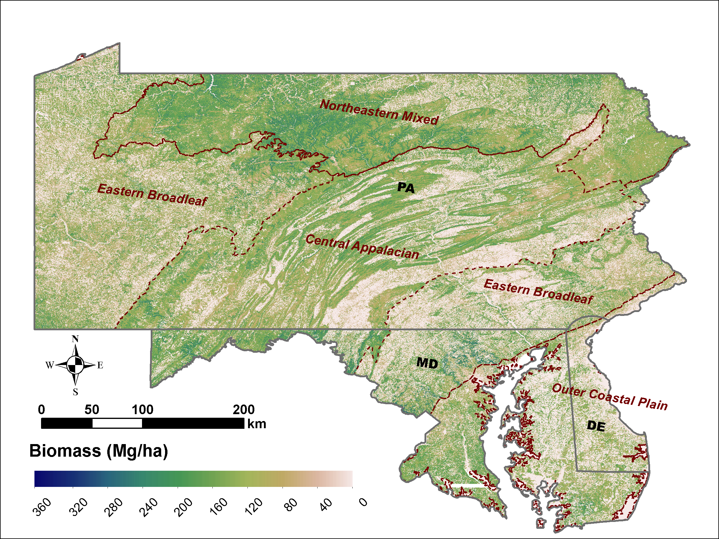
LiDAR Derived Biomass, Canopy Height and Cover for Tri-State (MD, PA, DE) Region, V2
National Aeronautics and Space Administration —
This dataset provides 30-meter gridded estimates of aboveground biomass (AGB), forest canopy height, and canopy coverage for Maryland, Pennsylvania, and Delaware in... -
Federal
In Support of the U.S. Fish and Wildlife Service 3-Bat Species Status Assessment: Predicted Wind Take Allocated To Hibernacula Each Year Under Current and Future Scenarios
Department of the Interior —
Through the North American Bat Monitoring Program (NABat), United States Geological Survey (USGS) provided technical and science support to assist in U.S. Fish and... -
County
Allegheny County Toxics Release Inventory
Allegheny County / City of Pittsburgh / Western PA Regional Data Center —
The Toxics Release Inventory (TRI) data provides information about toxic substances released into the environment or managed through recycling, energy recovery, and... -
Federal
Characterization data on the effects of micro-computed tomography-based x-ray radiation on vinyl nitrile foam
National Institute of Standards and Technology —
This dataset contains information from investigating the effects of micro-computed tomographic imaging irradiation on vinyl nitrile foam and code for a finite element... -
Federal
NOS CO-OPS Water Level Data, Verified, Hourly
National Oceanic and Atmospheric Administration, Department of Commerce —
This dataset has verified (quality-controlled), hourly, water level (tide) data from NOAA NOS Center for Operational Oceanographic Products and Services (CO-OPS).... -
Federal
Coral bleaching data from Bleachwatch in the Florida Keys National Marine Sanctuary from 2022-06-01 to 2022-10-26 (NCEI Accession 0276272)
National Oceanic and Atmospheric Administration, Department of Commerce —
As the occurence and severity of coral bleaching has increased in the Florida Keys National Marine Sanctuary (FKNMS) since the 1980âs, The U.S. National Oceanic and... -
Federal
Research Report of Low Temperature Geothermal Play Fairway Analysis for the Appalachian Basin
Department of Energy —
This is a final report summarizing a one-year (2014-15) DOE funded Geothermal Play Fairway Analysis of the Low-Temperature resources of the Appalachian Basin of New... -
Federal
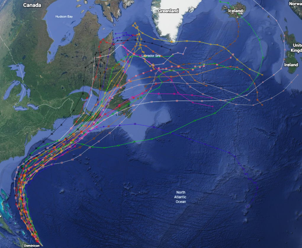
GRIP Hurricane and Tropical Storm Forecasts V1
National Aeronautics and Space Administration —
The GRIP Hurricane and Tropical Storm Forecasts dataset consists of tropical cyclone model forecast tracks archived during the NASA Genesis and Rapid Intensification... -
Federal
Grass-Cast Database - Data on aboveground net primary productivity (ANPP), climate data, NDVI, and cattle weight gain for Western U.S. rangelands
Department of Agriculture —
Grass-Cast: Experimental Grassland Productivity Forecast for the Great Plains Grass-Cast uses almost 40 years of historical data on weather and vegetation growth in... -
Federal
Sexual Assault During and After Separation or Divorce in Rural Ohio, 2003-2004
Department of Justice —
This qualitative study explored incidents of sexual assault of women by former husbands or cohabitants and the link to male peer support for sexually aggressive men... -
Federal
Plots of Wind Patterns for the World’s Volcanoes
Department of the Interior —
This product includes rose diagrams and tables of wind patterns at volcanoes listed in the Smithsonian Institution’s Volcanoes of the World Database. At each volcano,... -
Federal
Global Man-made Impervious Surface (GMIS) Dataset From Landsat
National Aeronautics and Space Administration —
The Global Man-made Impervious Surface (GMIS) Dataset From Landsat consists of global estimates of fractional impervious cover derived from the Global Land Survey... -
Federal
Backcountry Campsites, Great Smoky Mountains National Park
Department of the Interior —
Many people enjoy the solitude and primitive experience of camping away from developed campgrounds and other campers. Dispersed camping is the term used for camping... -
Federal
IHS Facility Locator
U.S. Department of Health & Human Services —
This map can be used to find an Indian Health Service, Tribal or Urban Indian Health Program facility. This map can be used to: Zoom in to a general location to see... -
City
SMART Bus Route 2017
City of Ferndale, Michigan —
Most current available data on Suburban Mobility Authority for Regional Transportation (SMART) bus routes in the Tri-County area of Southeast Michigan.Click here for... -
Federal
Global Human Built-up And Settlement Extent (HBASE) Dataset From Landsat
National Aeronautics and Space Administration —
The Global Human Built-up And Settlement Extent (HBASE) Dataset from Landsat is a global map of HBASE derived from the Global Land Survey (GLS) Landsat dataset for...

Official websites use .gov
A
.gov website belongs to an official government
organization in the United States.
Secure .gov websites use HTTPS
A
lock (
) or https:// means you’ve safely connected to
the .gov website. Share sensitive information only on official,
secure websites.