

6 datasets found
-
Federal
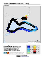
Indicators of Coastal Water Quality: Change in Chlorophyll-a Concentration 1998-2007
National Aeronautics and Space Administration —
The Change in Chlorophyll-a Concentrations 1998-2007 component of the Indicators of Coastal Water Quality Collection represents a tabular time series of the... -
Federal
Global Mangrove Forests Distribution, 2000
National Aeronautics and Space Administration —
The Global Mangrove Forests Distribution, 2000 data set is a compilation of the extent of mangroves forests from the Global Land Survey and the Landsat archive with... -
Federal
West Africa Coastal Vulnerability Mapping: Subset of High and Low Resolution Altimeter Corrected Elevations 2 (ACE2)
National Aeronautics and Space Administration —
The West Africa Coastal Vulnerability Mapping: Subset of High and Low Resolution Altimeter Corrected Elevations 2 (ACE2) data set consists of extracts from the 3 arc-... -
Federal
Indicators of Coastal Water Quality: Ancillary Data
National Aeronautics and Space Administration —
The Ancillary Data component of the Indicators of Coastal Water Quality Collection includes a 5 arc-minute (approximately 9 x 9 km at the equator) sequence grid, grid... -
Federal
Indicators of Coastal Water Quality: Annual Chlorophyll-a Concentration 1998-2007
National Aeronautics and Space Administration —
The Annual Chlorophyll-a Concentrations component of the Indicators of Coastal Water Quality Collection consists of gridded satellite measurements of chlorophyll-a... -
Federal
West Africa Coastal Vulnerability Mapping: Mangrove Forests Distribution, 2000 Polygon
National Aeronautics and Space Administration —
The West Africa Coastal Vulnerability Mapping: Mangrove Forests Distribution, 2000 Polygon data set was derived from the 30m resolution NASA Socioeconomic Data and...
6 datasets found