
-
Federal
Poverty Mapping Project: Poverty and Food Security Case Studies 49 recent views
National Aeronautics and Space Administration —
The Poverty Mapping Project: Poverty and Food Security Case Studies data set consists of small area estimates of poverty, inequality, food security and related... -
Federal
Poverty Mapping Project: Global Subnational Prevalence of Child Malnutrition 11 recent views
National Aeronautics and Space Administration —
The Poverty Mapping Project: Global Subnational Prevalence of Child Malnutrition data set consists of estimates of the percentage of children with weight-for-age... -
Federal
India Village-Level Geospatial Socio-Economic Data Set: 1991, 2001
National Aeronautics and Space Administration —
The India Village-Level Geospatial Socio-Economic Data Set: 1991, 2001 is a compilation of the finest level of administrative boundaries in India (village/town-level)... -
Federal
Poverty Mapping Project: Small Area Estimates of Poverty and Inequality
National Aeronautics and Space Administration —
The Poverty Mapping Project: Small Area Estimates of Poverty and Inequality data set consists of consumption-based poverty, inequality and related measures for... -
Federal
Shared Socioeconomic Pathways (SSPs) Literature Database, v1, 2014-2019
National Aeronautics and Space Administration —
The Shared Socioeconomic Pathways (SSPs) Literature Database, v1, 2014-2019 consists of biographic information, abstracts, and analysis of 1,360 articles published... -
Federal
China Dimensions Data Collection: China County-Level Data from Provincial Economic Yearbooks, Keyed to 1:1M GIS Map
National Aeronautics and Space Administration —
The China County-Level Data on Provincial Economic Yearbooks, Keyed To 1:1M GIS Map consists of socioeconomic and boundary data for the administrative regions of... -
Federal
Global Database of Light-based Geospatial Income Inequality (LGII) Measures, Version 1
National Aeronautics and Space Administration —
The Global Database of Light-based Geospatial Income Inequality (LGII) Measures, Version 1 data set contains Gini-coefficients of inequality for 234 countries and... -
Federal
China Dimensions Data Collection: Priority Programme for China's Agenda 21
National Aeronautics and Space Administration —
The Priority Programme for China's Agenda 21 consists of full-text program descriptions supporting China's economic and social development. The descriptions represent... -
Federal
Global 1-km Downscaled Population Base Year and Projection Grids Based on the Shared Socioeconomic Pathways, Revision 01
National Aeronautics and Space Administration —
The Global 1-km Downscaled Population Base Year and Projection Grids Based on the Shared Socioeconomic Pathways, Revision 01, data set consists of global urban,... -
Federal
West Africa Coastal Vulnerability Mapping: Gridded Subset of Sub-national Poverty and Extreme Poverty Prevalence
National Aeronautics and Space Administration —
The West Africa Coastal Vulnerability Mapping: Gridded Subset of Sub-national Poverty and Extreme Poverty Prevalence represents the HarvestChoice Subnational Poverty... -
Federal
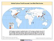
Global Cyclone Total Economic Loss Risk Deciles
National Aeronautics and Space Administration —
The Global Cyclone Total Economic Loss Risk Deciles is a 2.5 minute grid of global cyclone total economic loss risks. A process of spatially allocating Gross Domestic... -
Federal
Global Landslide Total Economic Loss Risk Deciles
National Aeronautics and Space Administration —
The Global Landslide Total Economic Loss Risk Deciles is a 2.5 minute grid of global landslide total economic loss risks. A process of spatially allocating Gross... -
Federal
Global Volcano Total Economic Loss Risk Deciles
National Aeronautics and Space Administration —
Global Volcano Total Economic Loss Risk Deciles is a 2.5 minute grid of global volcano total economic loss risks. First, subnational distributions of Gross Domestic... -
Federal
West Africa Coastal Vulnerability Mapping: Social Vulnerability Indices
National Aeronautics and Space Administration —
The West Africa Coastal Vulnerability Mapping: Social Vulnerability Indices data set includes three indices: Social Vulnerability, Population Exposure, and Poverty... -
Federal
Global Flood Proportional Economic Loss Risk Deciles
National Aeronautics and Space Administration —
The Global Flood Proportional Economic Loss Risk Deciles is a 2.5 minute grid of flood hazard economic loss as proportions of Gross Domestic Product (GDP) per... -
Federal
Global One-Eighth Degree Population Base Year and Projection Grids Based on the Shared Socioeconomic Pathways, Revision 01
National Aeronautics and Space Administration —
The Global One-Eighth Degree Population Base Year and Projection Grids Based on the Shared Socioeconomic Pathways, Revision 01, data set consists of global urban,... -
Federal
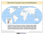
Global Volcano Proportional Economic Loss Risk Deciles
National Aeronautics and Space Administration —
Global Volcano Proportional Economic Loss Risk Deciles is a 2.5 minute grid of volcano hazard economic loss as proportions of Gross Domestic Product (GDP) per...

Official websites use .gov
A
.gov website belongs to an official government
organization in the United States.
Secure .gov websites use HTTPS
A
lock (
) or https:// means you’ve safely connected to
the .gov website. Share sensitive information only on official,
secure websites.