
-
Federal
IPCC Socio-Economic Baseline Dataset
National Aeronautics and Space Administration —
The Intergovernmental Panel on Climate Change (IPCC) Socio-Economic Baseline Dataset consists of population, human development, economic, water resources, land cover,... -
Federal
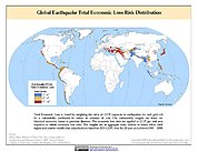
Global Earthquake Total Economic Loss Risk Deciles
National Aeronautics and Space Administration —
The Global Earthquake Total Economic Loss Risk Deciles is a 2.5 minute grid of global earthquake total economic loss risks. A process of spatially allocating Gross... -
Federal
Global Earthquake Proportional Economic Loss Risk Deciles
National Aeronautics and Space Administration —
The Global Earthquake Proportional Economic Loss Risk Deciles is a 2.5 minute grid of earthquake hazard economic loss as proportions of Gross Domestic Product (GDP)... -
Federal
Global Rural-Urban Mapping Project, Version 1 (GRUMPv1): Population Count Grid
National Aeronautics and Space Administration —
The Global Rural-Urban Mapping Project, Version 1 (GRUMPv1): Population Count Grid estimates human population for the years 1990, 1995, and 2000 by 30 arc-second (1... -
Federal
Last of the Wild Project, Version 2, 2005 (LWP-2): Global Human Footprint Dataset (IGHP)
National Aeronautics and Space Administration —
The Global Human Footprint Dataset of the Last of the Wild Project, Version 2, 2005 (LWP-2) is the Human Influence Index (HII) normalized by biome. The HII is a... -
Federal
Country-Level GDP and Downscaled Projections Based on the SRES A1, A2, B1, and B2 Marker Scenarios, 1990-2100
National Aeronautics and Space Administration —
The Country-Level GDP and Downscaled Projections Based on the Special Report on Emissions Scenarios (SRES) A1, A2, B1, and B2 marker scenarios, 1990-2100, were... -
Federal
Dar es Salaam Land Use and Informal Settlement Data Set
National Aeronautics and Space Administration —
The Dar es Salaam Land Use and Informal Settlement Data Set represents urban land use and consolidation of informal settlements for the years 1982, 1992, 1998, and... -
Federal
Compendium of Environmental Sustainability Indicator Collections: Rio to Johannesburg Dashboard of Sustainable Indicators
National Aeronautics and Space Administration —
The Rio to Johannesburg Dashboard of Sustainable Development Indicators portion of the Compendium of Environmental Sustainability Indicator Collections contains 35... -
Federal
Global Volcano Hazard Frequency and Distribution
National Aeronautics and Space Administration —
Global Volcano Hazard Frequency and Distribution is a 2.5 minute gridded data set based upon the National Geophysical Data Center (NGDC) Volcano Database spanning the... -
Federal
Global Drought Total Economic Loss Risk Deciles
National Aeronautics and Space Administration —
The Global Drought Total Economic Loss Risk Deciles is a 2.5 minute grid of global drought total economic loss risks. A process of spatially allocating Gross Domestic... -
Federal
Low Elevation Coastal Zone (LECZ) Urban-Rural Population Estimates, Global Rural-Urban Mapping Project (GRUMP), Alpha Version
National Aeronautics and Space Administration —
The Low Elevation Coastal Zone (LECZ) Urban-Rural Population Estimates consists of country-level estimates of urban, rural and total population and land area country-... -
Federal
Trends in Global Freshwater Availability from the Gravity Recovery and Climate Experiment (GRACE)
National Aeronautics and Space Administration —
The Trends in Global Freshwater Availability from the Gravity Recovery and Climate Experiment (GRACE), 2002-2016, is a global gridded data set at a spatial resolution... -
Federal
Gridded Population of the World, Version 3 (GPWv3): National Administrative Boundaries
National Aeronautics and Space Administration —
The Gridded Population of the World, Version 3 (GPWv3): National Administrative Boundaries are derived from the land area grid to show the outlines of pixels (cells)... -
Federal
Annual PM2.5 Concentrations for Countries and Urban Areas, 1998-2016 NGDA
National Aeronautics and Space Administration —
The Annual PM2.5 Concentrations for Countries and Urban Areas, 1998-2016, consists of mean concentrations of particulate matter (PM2.5) for countries and urban areas.... -
Federal
CODATA Catalog of Roads Data Sets, Version 1
National Aeronautics and Space Administration —
The CODATA Catalog of Roads Data Sets, Version 1 contains 367 entries describing national-level road network data sets for 147 countries and four entries describing... -
Federal
West Africa Coastal Vulnerability Mapping: Demographic and Health Survey Data Sets
National Aeronautics and Space Administration —
The West Africa Coastal Vulnerability Mapping: Demographic and Health Survey Data Sets present grids of maternal education levels and household wealth based on... -
Federal
2012 Environmental Performance Index and Pilot Trend Environmental Performance Index
National Aeronautics and Space Administration —
The 2012 Environmental Performance Index (EPI) ranks 132 countries on 22 performance indicators in the following 10 policy categories: environmental burden of... -
Federal
Country-Level Population and Downscaled Projections Based on the SRES A1, B1, and A2 Scenarios, 1990-2100
National Aeronautics and Space Administration —
The Country-Level Population and Downscaled Projections Based on Special Report on Emissions Scenarios (SRES) A1, B1, and A2 Scenarios, 1990-2100, were adopted in... -
Federal
West Africa Coastal Vulnerability Mapping: Deforestation, 2000-2012
National Aeronautics and Space Administration —
The West Africa Coastal Vulnerability Mapping: Deforestation, 2000-2012, layer was created from the Global Forest Change data set which represents global tree cover...

Official websites use .gov
A
.gov website belongs to an official government
organization in the United States.
Secure .gov websites use HTTPS
A
lock (
) or https:// means you’ve safely connected to
the .gov website. Share sensitive information only on official,
secure websites.