
-
Federal
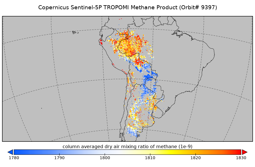
Sentinel-5P TROPOMI Methane CH4 1-Orbit L2 5.5km x 7km V1 (S5P_L2__CH4____HiR) at GES DISC
National Aeronautics and Space Administration —
Starting from August 6th in 2019, Sentinel-5P TROPOMI along-track high spatial resolution (~5.5km at nadir) has been implemented. For data before August 6th of 2019,... -
Federal
Multi-Satellite Air Quality Sulfur Dioxide (SO2) Database Long-Term L4 Global V2 (MSAQSO2L4) at GES DISC
National Aeronautics and Space Administration —
These data are a part of Multi-Decadal Sulfur Dioxide (SO2) Climatology from Satellite Instruments (MEaSUREs-12-0022 project). Version 2 of the global catalogue of... -
Federal
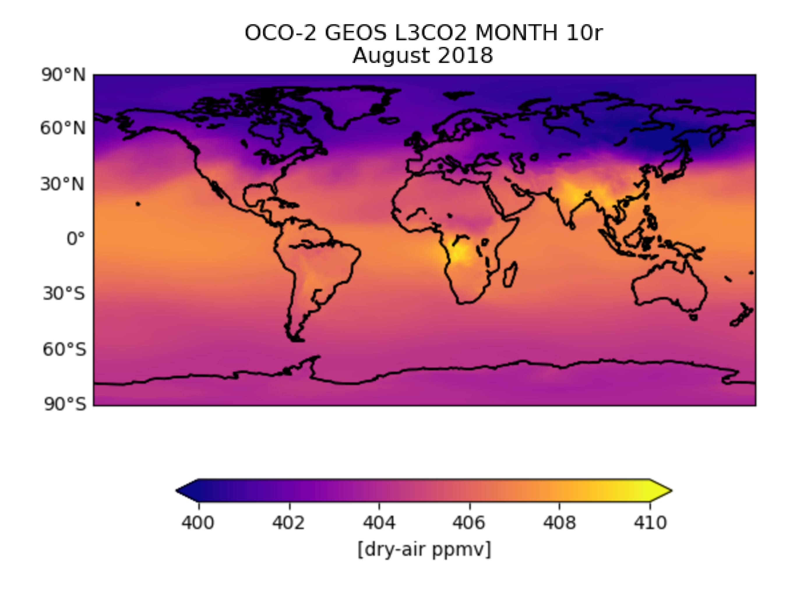
OCO-2 GEOS Level 3 monthly, 0.5x0.625 assimilated CO2 V10r (OCO2_GEOS_L3CO2_MONTH) at GES DISC
National Aeronautics and Space Administration —
This is the Gridded Monthly OCO-2 Carbon Dioxide assimilated dataset. The OCO-2 mission provides the highest quality space-based XCO2 retrievals to date. However, the... -
Federal
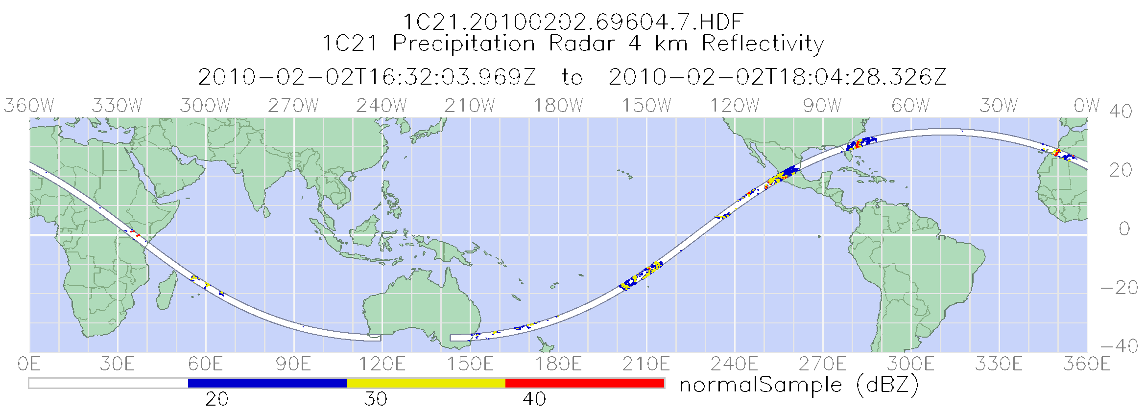
TRMM Precipitation Radar Power and Reflectivity L1C 1.5 hours V7 (TRMM_1C21) at GES DISC
National Aeronautics and Space Administration —
The TRMM Precipitation Radar (PR), the first of its kind in space, is an electronically scanning radar, operating at 13.8 GHz that measures the 3-D rainfall... -
Federal
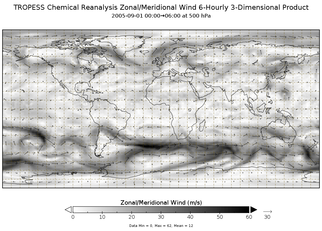
TROPESS Chemical Reanalysis Zonal Wind 6-Hourly 3-dimensional Product V1 (TRPSCRU6H3D) at GES DISC
National Aeronautics and Space Administration —
The TROPESS Chemical Reanalysis Zonal Wind 6-Hourly 3-dimensional Product contains vertical zonal wind component (u vector) values, a meteorological field. The data... -
Federal
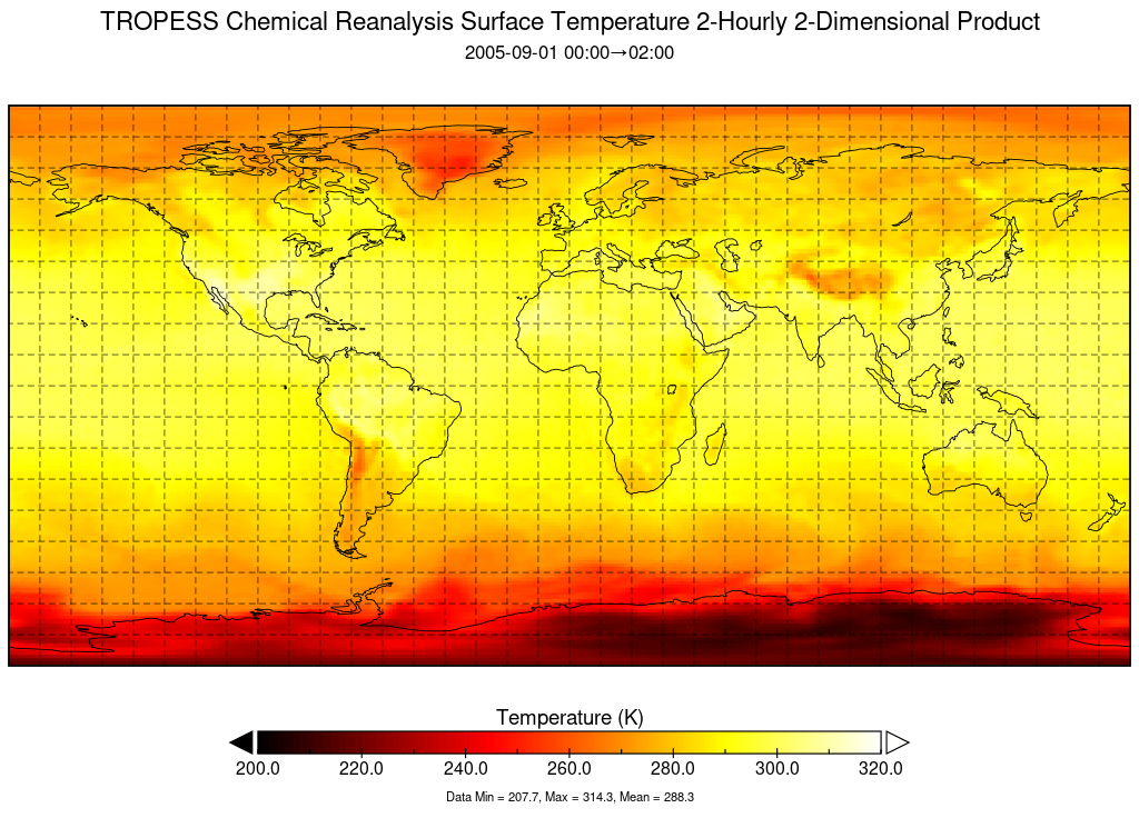
TROPESS Chemical Reanalysis Surface Temperature 2-Hourly 2-dimensional Product V1 (TRPSCRT2H2D) at GES DISC
National Aeronautics and Space Administration —
The TROPESS Chemical Reanalysis Surface Temperature 2-Hourly 2-dimensional Product contains surface temperature values, a meteorological field. The data are part of... -
Federal
Sentinel-5P TROPOMI Total Ozone Column 1-Orbit L2 7km x 3.5km V1 (S5P_L2__O3_TOT) at GES DISC
National Aeronautics and Space Administration —
Starting from August 6th in 2019, Sentinel-5P TROPOMI along-track high spatial resolution (~5.5km at nadir) has been implemented. Starting from July 13th in 2020,... -
Federal
OMI/Aura Formaldehyde (HCHO) Total Column Daily L3 Weighted Mean Global 0.1deg Lat/Lon Grid V003 (OMHCHOd) at GES DISC
National Aeronautics and Space Administration —
The OMI/Aura Formaldehyde (HCHO) Total Column Daily L3 Weighted Mean Global 0.1deg Lat/Lon Grid (OMHCHOd). The formaldehyde values in each file are the average for... -
Federal
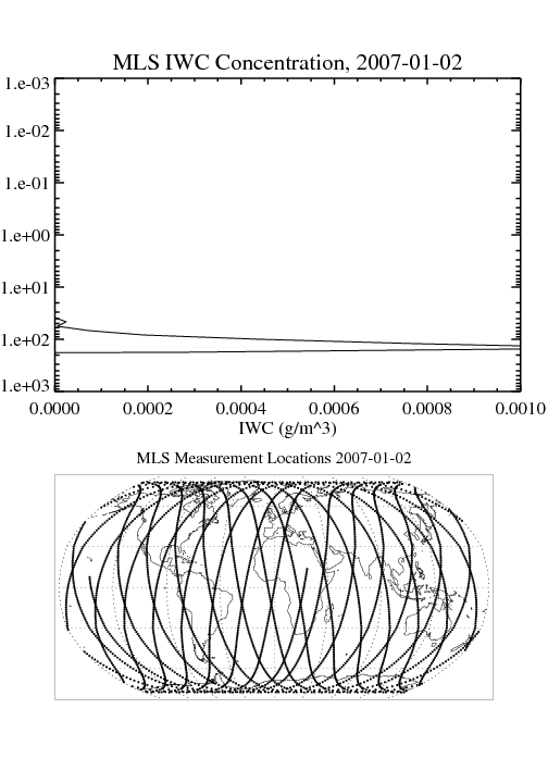
MLS/Aura Level 3 Daily Binned Cloud Ice (IWC) on Assorted Grids V005 (ML3DBIWC) at GES DISC
National Aeronautics and Space Administration —
ML3DBIWC is the EOS Aura Microwave Limb Sounder (MLS) daily binned on various vertical grids product for cloud ice water content (IWC) derived from radiances measured... -
Federal
SBUV2/NOAA-9 Ozone (O3) Profile and Total Column Ozone 1 Month Zonal Mean L3 Global 5.0 degree Latitude Zones V1 (SBUV2N09L3zm) at GES DISC
National Aeronautics and Space Administration —
The Solar Backscattered Ultraviolet (SBUV) from NOAA-9 Level-3 monthly zonal mean (MZM) product (SBUV2N17L3zm) is derived from the Level-2 retrieved ozone profiles.... -
Federal
TRMM Radar Rain Distributions L3 1 month 5 degree x 5 degree V7 (TRMM_3A26) at GES DISC
National Aeronautics and Space Administration —
The new version of these data is in GPM-like format (consistent with the GPM Dual-frequency Radar data format), and can be found under the name GPM_3PR. This dataset... -
Federal
AMSR-E/Aqua level 3 global monthly Surface Soil Moisture Averages V005 (AMSRE_AVRMO) at GES DISC
National Aeronautics and Space Administration —
The dataset contains global monthly-mean soil moisture statistics (average values) for 1 by 1 degree grid cells. The source for the data is AMSR-E daily estimates of... -
Federal
MLS/Aura Level 3 Daily Binned Relative Humidity With Respect To Ice (RHI) on Assorted Grids V005 (ML3DBRHI) at GES DISC
National Aeronautics and Space Administration —
ML3DBRHI is the EOS Aura Microwave Limb Sounder (MLS) daily binned on various vertical grids product for relative humidity with respect to ice (RHI) derived from... -
Federal
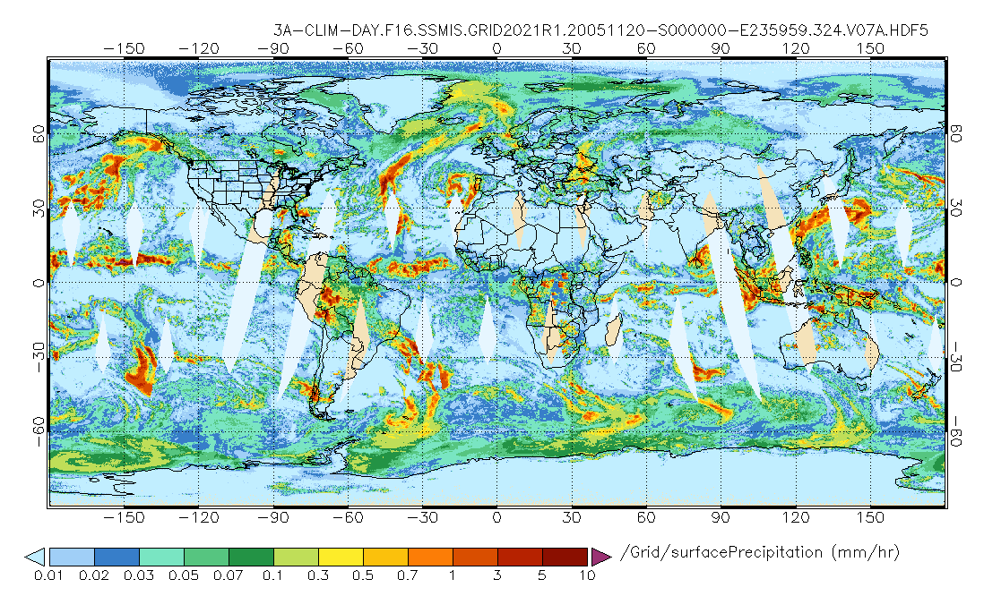
GPM SSMIS on F16 (GPROF) Climate-based Radiometer Precipitation Profiling L3 1 day 0.25 degree x 0.25 degree V07 (GPM_3GPROFF16SSMIS_DAY_CLIM) at GES DISC
National Aeronautics and Space Administration —
Version 07 is the current version of the data set. Older versions will no longer be available and have been superseded by Version 07. The "CLIM" products differ from... -
Federal
GPM SAPHIR on MT1 (PRPS) Climate-based Radiometer Precipitation Profiling L3 1 day 0.25 x 0.25 degree V06 (GPM_3PRPSMT1SAPHIR_DAY_CLIM) at GES DISC
National Aeronautics and Space Administration —
The "CLIM" products differ from their "regular" counterparts (without the "CLIM" in the name) by the ancillary data they use. They are Climate-Reference products,... -
Federal
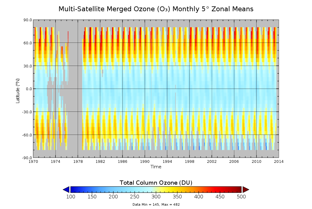
Multi-Satellite Merged Ozone (O3) Profile and Total Column 1 Month Zonal Mean L3 Global 5.0 degree Latitude Zones V1 (MSO3L3zm5) at GES DISC
National Aeronautics and Space Administration —
The merged-satellite Solar Backscattered Ultraviolet (SBUV) Level-3 monthly zonal mean (MZM) product (MSO3L3zm5) contains 1 month zonal means for profile layer and... -
Federal
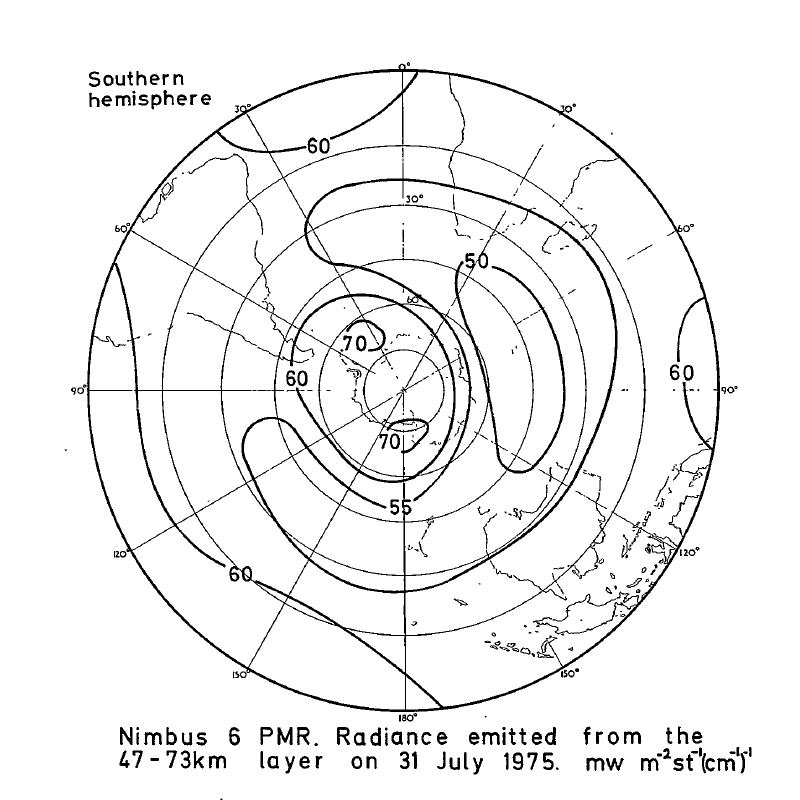
PMR/Nimbus-6 Level 1 Radiance Data from CD-ROM V001 (PMRN6L1RAD_CDROM) at GES DISC
National Aeronautics and Space Administration —
PMRN6L1RAD_CDROM is the gridded Nimbus-6 Pressure Modulated Radiometer (PMR) Level 1 Radiance Data Product. The radiances are measured at CO2 lines in the 15 micron... -
Federal
SBUV2/NOAA-9 Level 2 Daily Ozone Profile and Total Column from CD-ROM V008 (SBUV2N09O3) at GES DISC
National Aeronautics and Space Administration —
The version 8 SBUV/2 NOAA-9 ozone data were first released at the 2004 Quadrennial Ozone Symposium on DVD. The DVD contained all of the SBUV/2 data from NOAA-9,... -
Federal
OCO-2 Level 2 meteorological parameters interpolated from global assimilation model for each sounding V11 (OCO2_L2_Met) at GES DISC
National Aeronautics and Space Administration —
Version 11 is the current version of the data set. Older versions will no longer be available and are superseded by Version 11. The Orbiting Carbon Observatory is the... -
Federal
MLS/Aura Level 2 Cloud Ice Product V004 (ML2IWC) at GES DISC
National Aeronautics and Space Administration —
ML2IWC is the EOS Aura Microwave Limb Sounder (MLS) standard product for cloud ice water content derived from radiances measured by the 240 GHz radiometer. The data...

Official websites use .gov
A
.gov website belongs to an official government
organization in the United States.
Secure .gov websites use HTTPS
A
lock (
) or https:// means you’ve safely connected to
the .gov website. Share sensitive information only on official,
secure websites.