
-
Federal
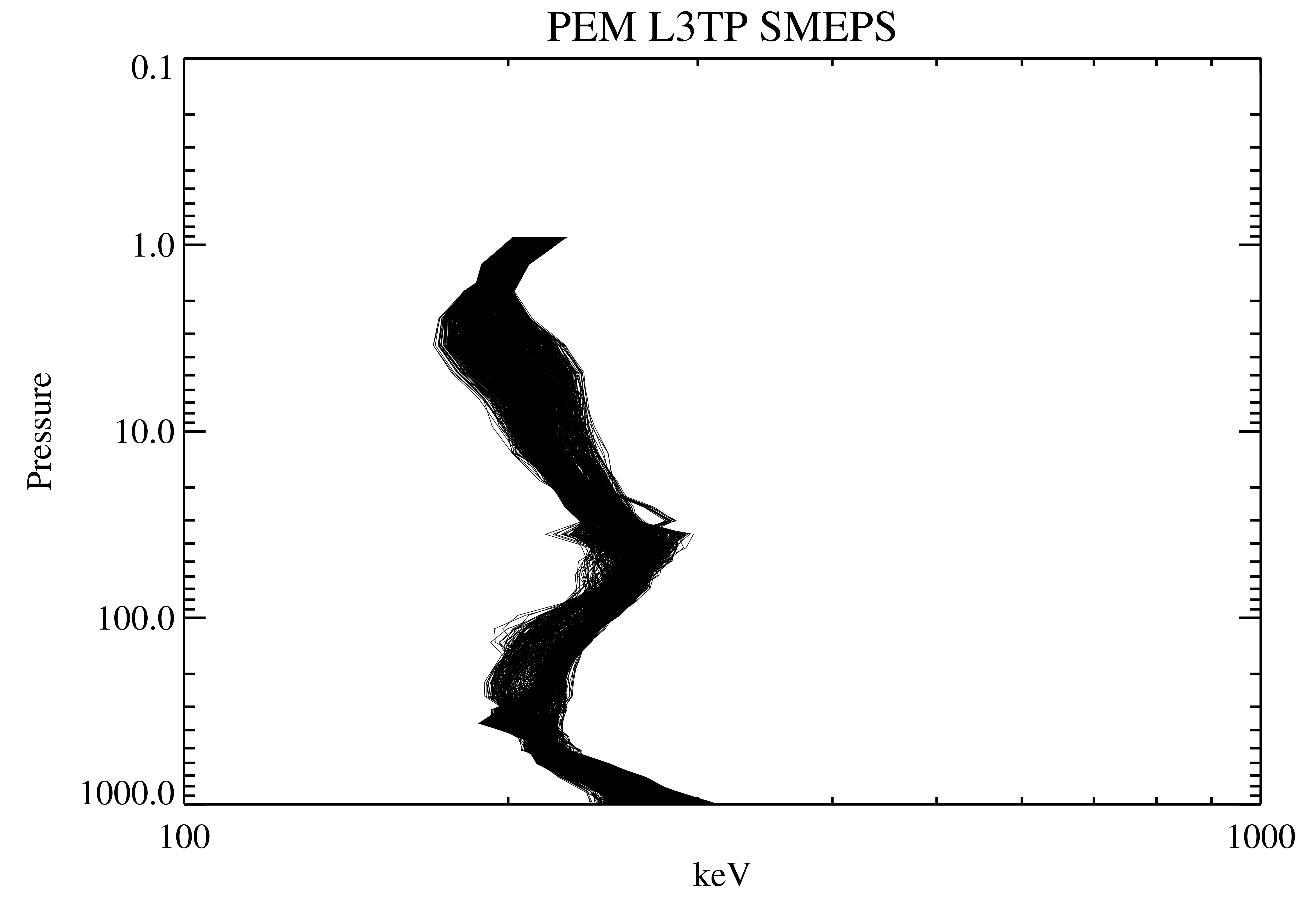
UARS PEM Level 2 HEPS B V001 (UARPE2HEPSB) at GES DISC
National Aeronautics and Space Administration —
The Particle Environment Monitor (PEM) level 2 High-Energy Particle Spectrometer (HEPS) B daily product contains the electron high-resolution spectral data converted... -
Federal
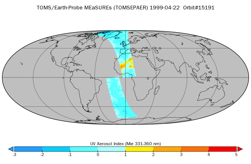
TOMS/EP Near UV Aerosol Index and LER 1-Orbit L2 40x40km at GES DISC
National Aeronautics and Space Administration —
As part of the NASA's Making Earth System Data Records for Use in Research Environments (MEaSUREs) program, this projects describes a multi-decadal Fundamental... -
Federal
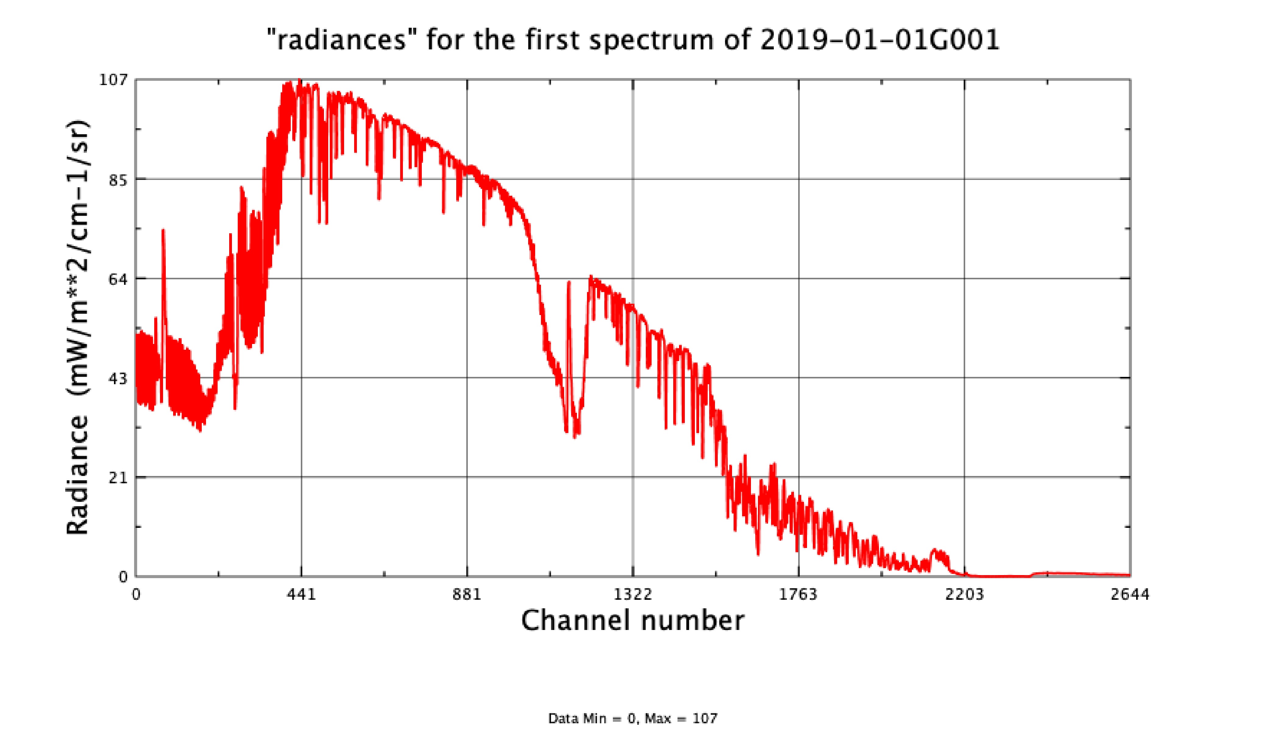
AIRS/Aqua L1C Infrared (IR) resampled and corrected radiances V6.7 (AIRICRAD) at GES DISC
National Aeronautics and Space Administration —
WARNING: AIRS L1C v6.7 has been impacted by an Aqua Deep Space Maneuver on Sept 23, 2021. Full data impact is still being assessed and an update to the AIRS L1C... -
Federal
Sentinel-5P TROPOMI Cloud 1-Orbit L2 5.5km x 3.5km V1 (S5P_L2__CLOUD__HiR) at GES DISC
National Aeronautics and Space Administration —
Starting from August 6th in 2019, Sentinel-5P TROPOMI along-track high spatial resolution (~5.5km at nadir) has been implemented. Starting from July 13th in 2020,... -
Federal
MLS/Aura L1 Radiances from Filter Banks for THz V005 (ML1RADT) at GES DISC
National Aeronautics and Space Administration —
ML1RADT is the EOS Aura Microwave Limb Sounder (MLS) product containing the level 1 radiances from the filter banks for the GHz radiometers. The data version is 5.0.... -
Federal
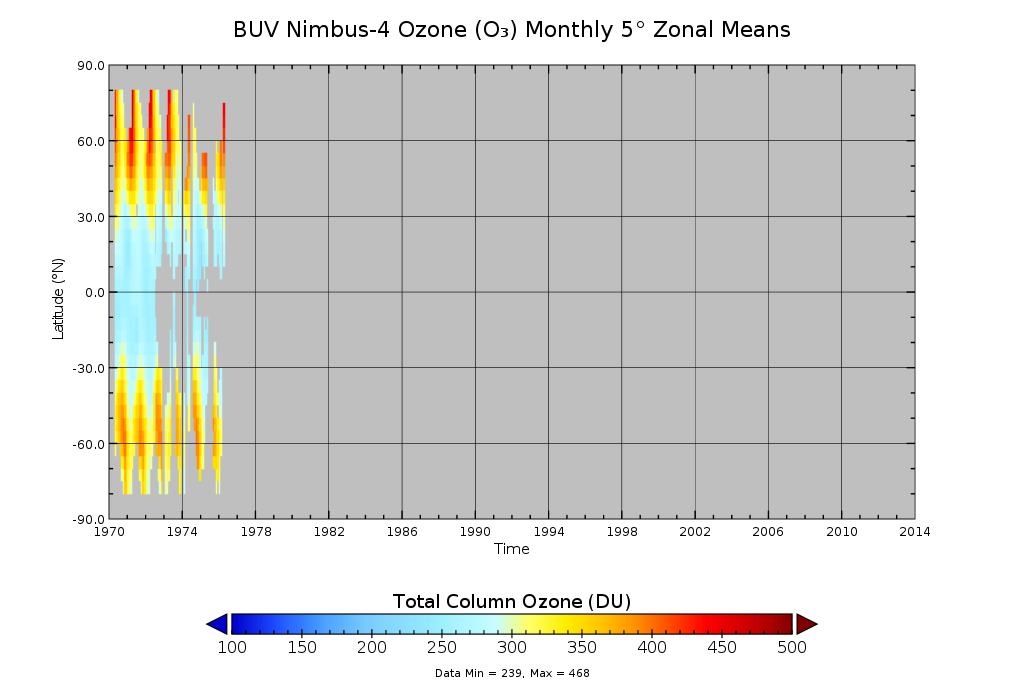
BUV/Nimbus-4 Ozone (O3) Profile and Total Column Ozone 1 Month Zonal Mean L3 Global 5.0 degree Latitude Zones V1 (BUVN04L3zm) at GES DISC
National Aeronautics and Space Administration —
The Solar Backscattered Ultraviolet (SBUV) from Nimbus-4 Level-3 monthly zonal mean (MZM) product (BUVN04L3zm) is derived from the Level-2 retrieved ozone profiles.... -
Federal
WindSat/Coriolis surface soil moisture (LPRM) L3 1 day 25 km x 25 km nighttime V001 (LPRM_WINDSAT_NT_SOILM3) at GES DISC
National Aeronautics and Space Administration —
WindSat/Coriolis surface soil moisture (LPRM) L3 1 day 25 km x 25 km nighttime V001 is a Level 3 (gridded) data set. Its land surface parameters, surface soil... -
Federal
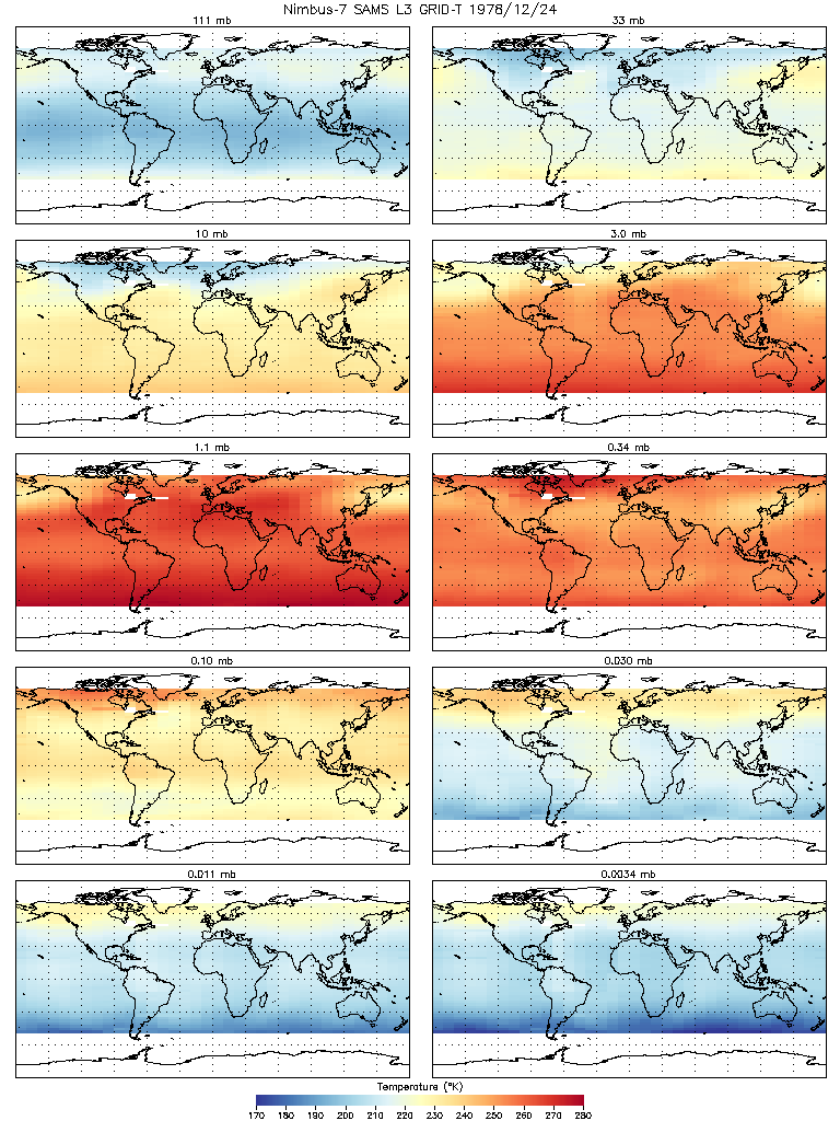
SAMS/Nimbus-7 Level 3 Gridded Retrieval Temperature Data V001 (SAMSN7L3GRIDT) at GES DISC
National Aeronautics and Space Administration —
SAMSN7L3GRIDT is the Nimbus-7 Stratospheric and Mesospheric Sounder (SAMS) Level 3 Gridded Retrieval Temperature Data Product. The Earth's surface is divided into 2.5... -
Federal
MLS/Aura Level 3 Daily Binned Sulfur Dioxide (SO2) Mixing Ratio on Assorted Grids V004 (ML3DBSO2) at GES DISC
National Aeronautics and Space Administration —
ML3DBSO2 is the EOS Aura Microwave Limb Sounder (MLS) daily binned on various vertical grids product for sulfur dioxide (SO2) derived from radiances measured by the... -
Federal
MLS/Aura Level 3 Monthly Binned Carbon Monoxide (CO) Mixing Ratio on Assorted Grids V004 (ML3MBCO) at GES DISC
National Aeronautics and Space Administration —
ML3MBCO is the EOS Aura Microwave Limb Sounder (MLS) monthly binned on various vertical grids product for carbon monoxide (CO) derived from radiances measured by the... -
Federal
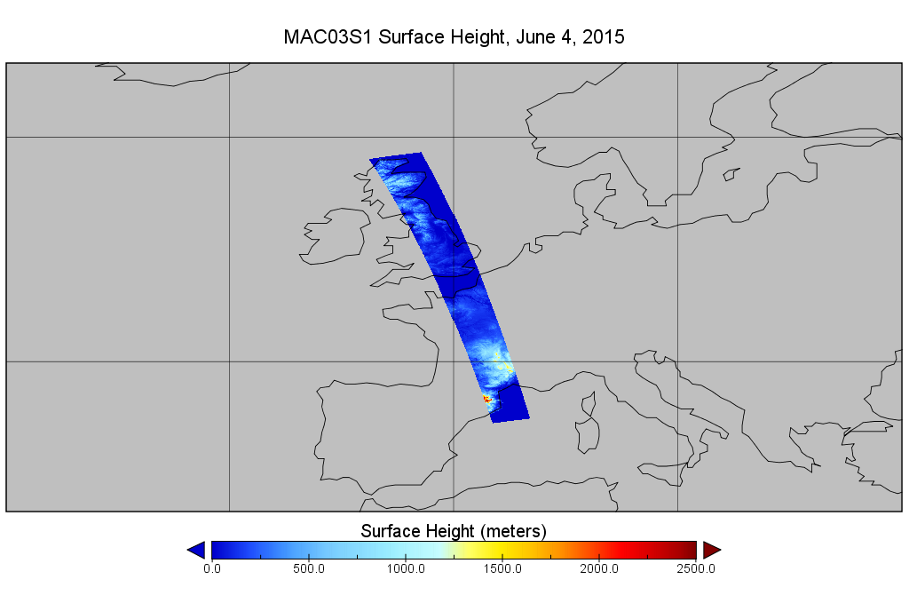
MODIS/Aqua Geolocation Fields 1km 5-Min 1A Wide Swath Subset along CloudSat V002 (MAC03S1) at GES DISC NGDA
National Aeronautics and Space Administration —
This is the wide-swath MODIS/Aqua subset along CloudSat field of view track. The goal of the wide-swath subset is to select and return MODIS data that are within... -
Federal
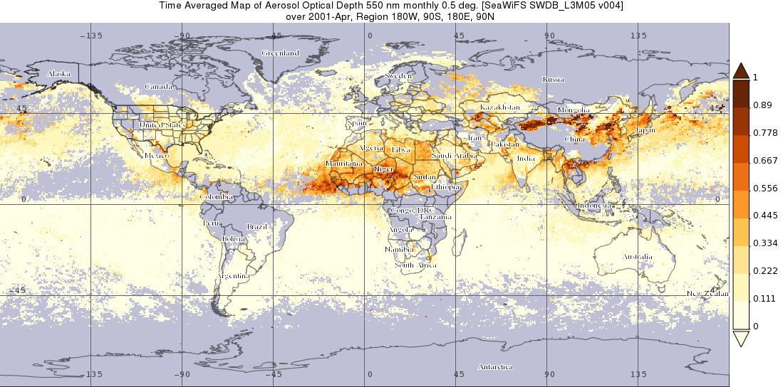
SeaWiFS Deep Blue Aerosol Optical Depth and Angstrom Exponent Monthly Level 3 Data Gridded at 0.5 Degrees V004 (SWDB_L3M05) at GES DISC
National Aeronautics and Space Administration —
The SeaWiFS Deep Blue Level 3 monthly product contains monthly global gridded (0.5 x 0.5 deg) Version 4 data derived from SeaWiFS Deep Blue Level 3 daily gridded data... -
Federal
TRMM Ground Validation Calibrated QC Radar Reflectivity Full Volume Scan L1C 1 hour V7 (TRMM_1C51UW) at GES DISC
National Aeronautics and Space Administration —
This dataset is part of the University of Washington TRMM Ground Validation products. Files are in "Universal Format", described in BAMS, Vol 61, No 11, November... -
Federal
UARS Solar-Stellar Irradiance Comparison Experiment (SOLSTICE) Level 3BS V018 (UARSO3BS) at GES DISC
National Aeronautics and Space Administration —
The Solar-Stellar Irradiance Comparison Experiment (SOLSTICE) Level 3BS data product consists of daily, 1 nm resolution, solar spectral irradiances and selected solar... -
Federal
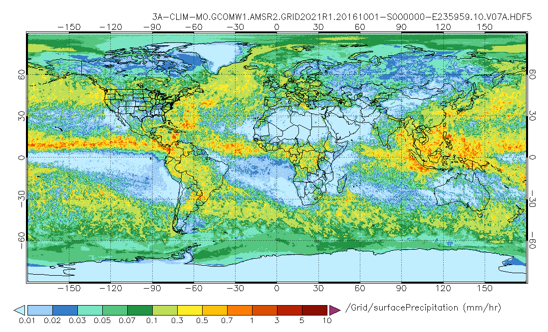
GPM AMSR-2 on GCOM-W1 (GPROF) Climate-based Radiometer Precipitation Profiling L3 1 month 0.25 degree x 0.25 degree V07 (GPM_3GPROFGCOMW1AMSR2_CLIM) at GES DISC
National Aeronautics and Space Administration —
Version 07 is the current version of the data set. Older versions will no longer be available and have been superseded by Version 07. The "CLIM" products differ from... -
Federal
MLS/Aura Near-Real-Time L2 Nitrous Oxide (N2O) Mixing Ratio V005 (ML2N2O_NRT) at GES DISC
National Aeronautics and Space Administration —
ML2N2O_NRT is the EOS Aura Microwave Limb Sounder (MLS) Near-Real-Time (NRT) product for nitrous oxide (N2O). This product contains N2O profiles derived from the 190... -
Federal
MLS/Aura Level 3 Monthly Binned Cloud Ice (IWC) on Assorted Grids V005 (ML3MBIWC) at GES DISC
National Aeronautics and Space Administration —
ML3MBIWC is the EOS Aura Microwave Limb Sounder (MLS) monthly binned on various vertical grids product for cloud ice water content (IWC) derived from radiances... -
Federal
MERRA-2 statM_2d_edi_Nx: 2d, Single-Level, Monthly Extremes Detection Indices V1 (M2SMNXEDI) at GES DISC
National Aeronautics and Space Administration —
The Modern Era Retrospective analysis for Research and Applications, Version 2 (MERRA-2) contains a wealth of information that can be used for weather and climate... -
Federal
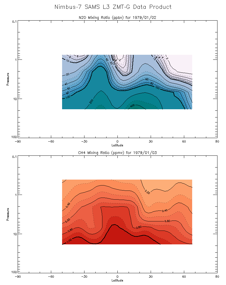
SAMS/Nimbus-7 Level 3 Zonal Means Composition Data V001 (SAMSN7L3ZMTG) at GES DISC
National Aeronautics and Space Administration —
SAMSN7L3ZMTG is the Nimbus-7 Stratospheric and Mesospheric Sounder (SAMS) Level 3 Zonal Means Composition Data Product. The Earth's surface is divided into 2.5-deg... -
Federal
OCO-2 Level 0 spacecraft attitude data, Retrospective Processing V11r (OCO2_Att) at GES DISC
National Aeronautics and Space Administration —
Version 11r is the current version of the data set. Older versions will no longer be available and are superseded by Version 11r. The Orbiting Carbon Observatory is...

Official websites use .gov
A
.gov website belongs to an official government
organization in the United States.
Secure .gov websites use HTTPS
A
lock (
) or https:// means you’ve safely connected to
the .gov website. Share sensitive information only on official,
secure websites.