
-
Federal
Poverty Mapping Project: Poverty and Food Security Case Studies 49 recent views
National Aeronautics and Space Administration —
The Poverty Mapping Project: Poverty and Food Security Case Studies data set consists of small area estimates of poverty, inequality, food security and related... -
Federal
Global Earthquake Hazard Distribution - Peak Ground Acceleration 28 recent views
National Aeronautics and Space Administration —
The Global Earthquake Hazard Distribution - Peak Ground Acceleration is a 2.5 minute grid of global earthquake hazards developed using Global Seismic Hazard Program... -
Federal
Georeferenced Population Datasets of Mexico (GEO-MEX): GIS of Mexican States, Municipalities and Islands 24 recent views
National Aeronautics and Space Administration —
The GIS of Mexican States, Municipalities and Islands consists of attribute and boundary data for 1990. The attribute data include population, language, education,... -
Federal
Global Gridded Geographically Based Economic Data (G-Econ), Version 4 18 recent views
National Aeronautics and Space Administration —
The Global Gridded Geographically Based Economic Data (G-Econ), Version 4 contains derived one degree grid cells of Gross Domestic Product (GDP) data in Grid and... -
Federal
U.S. EPA National Priorities List (NPL) Sites Point Data with CIESIN Modifications, Version 2 13 recent views
National Aeronautics and Space Administration —
The U.S. Environmental Protection Agency (EPA) National Priorities List (NPL) Sites Point Data with CIESIN Modifications, Version 2 is a modified version of the 2014... -
Federal
Black Sea High Resolution SST L4 Analysis 0.0625 deg Resolution NGDA 12 recent views
National Aeronautics and Space Administration —
CNR MED Sea Surface Temperature provides daily gap-free maps (L4) at 0.0625 deg. x 0.0625 deg. horizontal resolution over the Black Sea. The data are obtained from... -
Federal
Global Flood Hazard Frequency and Distribution 11 recent views
National Aeronautics and Space Administration —
The Global Flood Hazard Frequency and Distribution is a 2.5 minute grid derived from a global listing of extreme flood events between 1985 and 2003 (poor or missing... -
Federal
Poverty Mapping Project: Global Subnational Prevalence of Child Malnutrition 11 recent views
National Aeronautics and Space Administration —
The Poverty Mapping Project: Global Subnational Prevalence of Child Malnutrition data set consists of estimates of the percentage of children with weight-for-age... -
Federal
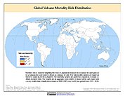
Global Volcano Mortality Risks and Distribution 10 recent views
National Aeronautics and Space Administration —
Global Volcano Mortality Risks and Distribution is a 2.5 minute grid representing global volcano mortality risks. The data set was constructed using historical... -
Federal
Global Roads Open Access Data Set, Version 1 (gROADSv1) 10 recent views
National Aeronautics and Space Administration —
The Global Roads Open Access Data Set, Version 1 (gROADSv1) was developed under the auspices of the CODATA Global Roads Data Development Task Group. The data set... -
Federal
Global Population Density Grid Time Series Estimates
National Aeronautics and Space Administration —
The Global Population Density Grid Time Series Estimates provide a back-cast time series of population density grids based on the year 2000 population grid from... -
Federal
HANPP Collection: Global Patterns in Net Primary Productivity (NPP)
National Aeronautics and Space Administration —
The HANPP Collection: Global Patterns in Net Primary Productivity (NPP) maps the net amount of solar energy converted to plant organic matter through photosynthesis.... -
Federal
Natural Resource Protection and Child Health Indicators, 2023 Release
National Aeronautics and Space Administration —
The Natural Resource Protection and Child Health Indicators, 2023 Release, is produced in support of the U.S. Millennium Challenge Corporation as selection criteria... -
Federal
China Dimensions Data Collection: China County-Level Data on Population (Census) and Agriculture, Keyed to 1:1M GIS Map
National Aeronautics and Space Administration —
The China County-Level Data on Population (Census) and Agriculture, Keyed To 1:1M GIS Map consists of census, agricultural economic, and boundary data for the... -
Federal
Global Annual PM2.5 Grids from MODIS, MISR and SeaWiFS Aerosol Optical Depth (AOD), 1998-2019, V4.GL.03 NGDA
National Aeronautics and Space Administration —
The Global Annual PM2.5 Grids from MODIS, MISR and SeaWiFS Aerosol Optical Depth (AOD), 1998-2019, V4.GL.03 consists of annual concentrations (micrograms per cubic... -
Federal
Images
National Aeronautics and Space Administration —
Images for the website main pages and all configurations. The upload and access points for the other images are: Website Template RSW images BSCW Images HIRENASD Images -
Federal
A Global Database of Gas Fluxes from Soils after Rewetting or Thawing, Version 1.0
National Aeronautics and Space Administration —
This database contains information compiled from published studies on gas flux from soil following rewetting or thawing. The resulting database includes 222 field and... -
Federal
India Village-Level Geospatial Socio-Economic Data Set: 1991, 2001
National Aeronautics and Space Administration —
The India Village-Level Geospatial Socio-Economic Data Set: 1991, 2001 is a compilation of the finest level of administrative boundaries in India (village/town-level)... -
Federal
ECCO Ocean Velocity - Daily Mean 0.5 Degree (Version 4 Release 4)
National Aeronautics and Space Administration —
This dataset contains daily-averaged ocean velocity interpolated to a regular 0.5-degree grid from the ECCO Version 4 revision 4 (V4r4) ocean and sea-ice state...

Official websites use .gov
A
.gov website belongs to an official government
organization in the United States.
Secure .gov websites use HTTPS
A
lock (
) or https:// means you’ve safely connected to
the .gov website. Share sensitive information only on official,
secure websites.