
-
Federal
ABoVE: Annual Thaw Slump Expansion on East Fork Chandalar River, Alaska, 2008-2017
National Aeronautics and Space Administration —
This dataset provides a time series of spatial data showing the expansion of a thaw slump on the East Fork Chandalar River near the community of Venetie, Alaska, from... -
Federal
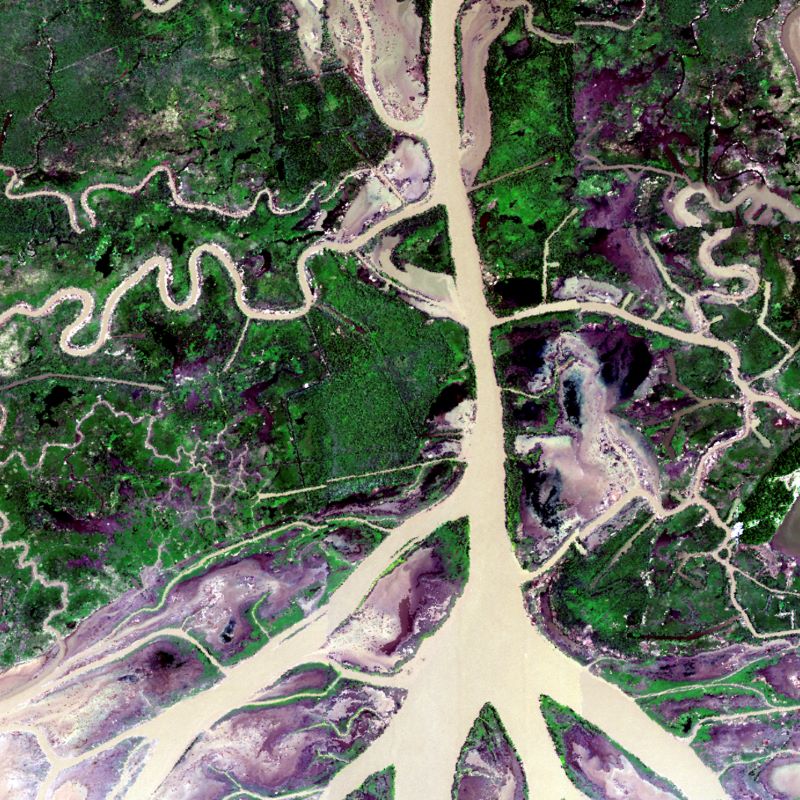
Global Mangrove Loss Extent, Land Cover Change, and Loss Drivers, 2000-2016
National Aeronautics and Space Administration —
This dataset provides estimates of the extent of mangrove loss, land cover change, and its anthropogenic or climatic drivers in three time periods: 2000-2005,... -
Federal
ISLSCP II Atmospheric Carbon Dioxide Consumption by Continental Erosion
National Aeronautics and Space Administration —
The Continental Atmospheric CO2 Consumption data set represents gridded estimates for the riverine export of carbon and of sediments based on empirical models. All... -
Federal
ISLSCP II Global Gridded Soil Characteristics
National Aeronautics and Space Administration —
This data set provides gridded data for selected soil parameters derived from data and methods developed by the Global Soil Data Task, an international collaborative... -
Federal
LBA-ECO ND-01 Streamwater and Watershed Characteristics, Rondonia, Brazil: 1998-1999
National Aeronautics and Space Administration —
This data set provides the results of (1) synoptic streamwater sampling and analyses from numerous sites across Rondonia and (2) corresponding watershed... -
Federal
ABoVE: Riverbank Erosion and Vegetation Changes, Yukon River Basin, Alaska, 1984-2017
National Aeronautics and Space Administration —
This dataset provides a time series of riverbank erosion and vegetation colonization along reaches of the Yukon River (3 study areas), Tanana and Nenana Rivers (1... -
Federal
Aboveground Biomass, Landcover, and Degradation, Kalimantan Forests, Indonesia, 2014
National Aeronautics and Space Administration —
This dataset provides estimates of aboveground biomass, percent canopy cover, mean canopy height, landcover, and forest degradation index products for forests in... -
Federal
Delta-X: AVIRIS-NG L2B BRDF-Adjusted Surface Reflectance, MRD, LA, 2021, V2
National Aeronautics and Space Administration —
This data provides AVIRIS-NG Bidirectional Reflectance Distribution Function (BRDF) and sunglint-corrected surface spectral reflectance images over the Atchafalaya... -
Federal
ISLSCP II Global River Fluxes of Carbon and Sediments to the Oceans
National Aeronautics and Space Administration —
The River Carbon Flux data set represents estimates for the riverine export of carbon and of sediments. This data set includes the amounts of carbon and of sediments... -
Federal
LBA-ECO LC-07 Lake Sediment Nutrient Data, Lago Calado, Brazil: 1982-1984
National Aeronautics and Space Administration —
This data set reports lake sediment texture and porosity, carbon (C), nitrogen (N), and phosphorus (P) content of surficial sediments, 210Pb-derived nutrient... -
Federal
BOREAS TGB-04 Water and Sediment Temperature Data over the NSA-BP (Beaver Pond)
National Aeronautics and Space Administration —
Contains TGB-04 water and sediment temperature data for northern study area (tower beaver pond site). -
Federal
Pre-Delta-X: Total Suspended Solids of Surface Water across MRD, LA, USA, 2015-2016
National Aeronautics and Space Administration —
This dataset contains the total suspended solids (TSS) concentration of in situ water samples collected at selected sites across the Atchafalaya and Terrebonne Basins... -
Federal
Delta-X: Island and Secondary Channel Model, MRD, LA, USA, 2022
National Aeronautics and Space Administration —
This dataset includes model code and output for a model that simulates changes in islands and small water channels of river delta systems in response to dynamics of... -
Federal
Global Soil Types, 1-Degree Grid (Zobler)
National Aeronautics and Space Administration —
A global digital data base of soil properties is available at 1 degree longitude resolution. For each land cell, the data base includes major and associated soil... -
Federal
Global 1-km Gridded Thickness of Soil, Regolith, and Sedimentary Deposit Layers
National Aeronautics and Space Administration —
This data set provides high-resolution estimates of the thickness of the permeable layers above bedrock (soil, regolith, and sedimentary deposits) within a global... -
Federal
ISLSCP II Total Plant-Available Soil Water Storage Capacity of the Rooting Zone
National Aeronautics and Space Administration —
This data set provides two estimates of the geographic distribution of the total plant-available soil water storage capacity of the rooting zone ("rooting zone water... -
Federal
Delta-X: Delft3D Broad-Scale Sediment Model, Atchafalaya Basin, MRD, Louisiana, USA
National Aeronautics and Space Administration —
This dataset contains the Delft3D model of the Atchafalaya Basin along the Mississippi River Delta (MRD) in coastal Louisiana. Simulations cover the Delta-X Spring...

Official websites use .gov
A
.gov website belongs to an official government
organization in the United States.
Secure .gov websites use HTTPS
A
lock (
) or https:// means you’ve safely connected to
the .gov website. Share sensitive information only on official,
secure websites.