
-
Federal
LISTOS NASA Aircraft Meteorological and Navigational Data
National Aeronautics and Space Administration —
LISTOS_MetNav_AircraftInSitu_NASAAircraft_Data is the Long Island Sound Tropospheric Ozone Study (LISTOS) in-situ meteorological and navigational data collected... -
Federal
GPM GROUND VALIDATION ER-2 X-BAND RADAR (EXRAD) IPHEX V1
National Aeronautics and Space Administration —
The GPM Ground Validation ER-2 X-band Radar (EXRAD) IPHEx dataset was collected in support of the Global Precipitation Measurement (GPM) mission Ground Validation... -
Federal
LBA-ECO TG-08 Trace Gas Fluxes from Wetted Forest and Pasture Soils, Rondonia, Brazil
National Aeronautics and Space Administration —
This data set includes the results of measurements of the soil gas fluxes of nitric oxide (NO), nitrous oxide (N2O), and carbon dioxide (CO2), soil moisture, soil... -
Federal
LBA-ECO ND-30 Fractional Cover of Mixed Land Use Ranches, Para and Rondonia, Brazil
National Aeronautics and Space Administration —
This data set contains images of fractional cover estimates of photosynthetic vegetation (PV) canopy, nonphotosynthetic vegetation (NPV), and exposed soils (S)... -
Federal
SAFARI 2000 Upper Air Meteorological Profiles, South Africa, Dry Season 2000
National Aeronautics and Space Administration —
The University of Wyoming has a series of balloonborne radiosonde measurements from all around the world, from the surface to 30 km. This data set contains upper air... -
Federal
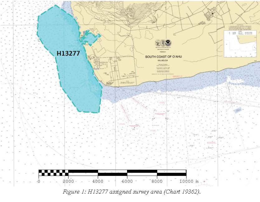
H13277: NOS Hydrographic Survey , 2019-09-18
National Oceanic and Atmospheric Administration, Department of Commerce —
The National Oceanic and Atmospheric Administration (NOAA) has the statutory mandate to collect hydrographic data in support of nautical chart compilation for safe... -
Federal
SAFARI 2000 Canopy Structural Measurements, Kalahari Transect, Wet Season 2001
National Aeronautics and Space Administration —
This data set contains leaf area index (LAI), leaf inclination angle, and canopy dimension data from study sites along the Kalahari Transect in southwest Botswana.... -
Federal
H13297: NOS Hydrographic Survey , 2019-12-21
National Oceanic and Atmospheric Administration, Department of Commerce —
The National Oceanic and Atmospheric Administration (NOAA) has the statutory mandate to collect hydrographic data in support of nautical chart compilation for safe... -
Federal
2022 Cartographic Boundary File (SHP), Current Unified School District for Ohio, 1:500,000
U.S. Census Bureau, Department of Commerce —
The 2022 cartographic boundary shapefiles are simplified representations of selected geographic areas from the U.S. Census Bureau's Master Address File /... -
Federal
H07095: NOS Hydrographic Survey , 1946-12-31
National Oceanic and Atmospheric Administration, Department of Commerce —
The National Oceanic and Atmospheric Administration (NOAA) has the statutory mandate to collect hydrographic data in support of nautical chart compilation for safe... -
Federal
LBA-ECO TG-07 Long-Term Soil Gas Flux and Root Mortality, Tapajos National Forest
National Aeronautics and Space Administration —
This data set reports measurements of trace gas fluxes of methane (CH4), nitric oxide (N2O), nitrous oxide (NO), carbon dioxide (CO2) from soils at a study site in... -
Federal
2020 Cartographic Boundary File (SHP), Current State Legislative District-Upper Chamber for Ohio, 1:500,000
U.S. Census Bureau, Department of Commerce —
The 2020 cartographic boundary shapefiles are simplified representations of selected geographic areas from the U.S. Census Bureau's Master Address File /... -
Federal
SAFARI 2000 Pre- and Post-fire Reflectance near Kaoma, Zambia, Dry Season 2000
National Aeronautics and Space Administration —
The main goal of this study was to analyze the possibility of estimating combustion completeness based on fire-induced spectral reflectance changes of surface... -
Federal
Northern North Pacific Regional Climatology version 2 (NCEI Accession 0283566)
National Oceanic and Atmospheric Administration, Department of Commerce —
The Northern North Pacific (NNP) is a resource-rich coastal zone with abundant fisheries and other material resources. The NNP Regional Climatology version 2 replaces... -
Federal
H13387: NOS Hydrographic Survey , 2021-02-07
National Oceanic and Atmospheric Administration, Department of Commerce —
The National Oceanic and Atmospheric Administration (NOAA) has the statutory mandate to collect hydrographic data in support of nautical chart compilation for safe... -
Federal
H13388: NOS Hydrographic Survey , 2021-05-15
National Oceanic and Atmospheric Administration, Department of Commerce —
The National Oceanic and Atmospheric Administration (NOAA) has the statutory mandate to collect hydrographic data in support of nautical chart compilation for safe... -
Federal
VIIRS/NPP Land Surface Temperature and Emissivity 6-Min L2 Swath 750 m
National Aeronautics and Space Administration —
The Near Real Time (NRT) VIIRSLand Surface Temperature and Emissivity 6-Min L2 Swath 750m product (VNP21_NRT) uses a physics-based algorithm to dynamically retrieve... -
Federal
LBA-ECO ND-02 Secondary Forest Small Stem, Non-Woody Biomass, Para, Brazil: 1999-2005
National Aeronautics and Space Administration —
This data set reports biomass from small stems and non-woody vegetation measured from 1999 to 2005 in plots of a secondary-growth forest fertilization experiment. The... -
Federal
H13302: NOS Hydrographic Survey , 2020-06-27
National Oceanic and Atmospheric Administration, Department of Commerce —
The National Oceanic and Atmospheric Administration (NOAA) has the statutory mandate to collect hydrographic data in support of nautical chart compilation for safe... -
Federal
2022 Cartographic Boundary File (SHP), Current Place for Washington, 1:500,000
U.S. Census Bureau, Department of Commerce —
The 2022 cartographic boundary shapefiles are simplified representations of selected geographic areas from the U.S. Census Bureau's Master Address File /...

Official websites use .gov
A
.gov website belongs to an official government
organization in the United States.
Secure .gov websites use HTTPS
A
lock (
) or https:// means you’ve safely connected to
the .gov website. Share sensitive information only on official,
secure websites.