
-
Federal
Gridded Species Distribution: Global Mammal Richness Grids, 2015 Release
National Aeronautics and Space Administration —
The 2015 Release of the Global Mammal Richness Grids data set of the Gridded Species Distribution collection are aggregations of the presence grids data for the... -
Federal
Shared Socioeconomic Pathways (SSPs) Literature Database, v1, 2014-2019
National Aeronautics and Space Administration —
The Shared Socioeconomic Pathways (SSPs) Literature Database, v1, 2014-2019 consists of biographic information, abstracts, and analysis of 1,360 articles published... -
Federal
China Dimensions Data Collection: Chinese County-Level Data on Hospitals and Epidemiology Stations, 1950-1985
National Aeronautics and Space Administration —
The China Dimensions Data Collection: Chinese County-Level Data on Hospitals and Epidemiology Stations, 1950-1985 consists of hospital and epidemiological station... -
Federal
Global Human Modification of Terrestrial Systems
National Aeronautics and Space Administration —
The Global Human Modification of Terrestrial Systems data set provides a cumulative measure of the human modification of terrestrial lands across the globe at a 1-km... -
Federal
Global Population Count Grid Time Series Estimates
National Aeronautics and Space Administration —
The Global Population Count Grid Time Series Estimates provide a back-cast time series of population grids based on the year 2000 population grid from SEDAC's Global... -
Federal
Last of the Wild Project, Version 2, 2005 (LWP-2): Global Human Footprint Dataset (Geographic)
National Aeronautics and Space Administration —
The Global Human Footprint Dataset of the Last of the Wild Project, Version 2, 2005 (LWP-2) is the Human Influence Index (HII) normalized by biome and realm. The HII... -
Federal
Yale Center for Earth Observation (YCEO) Surface Urban Heat Islands, Version 4, 2003-2018
National Aeronautics and Space Administration —
The Yale Center for Earth Observation (YCEO) Surface Urban Heat Islands, Version 4, 2003-2018 includes annual, summertime, and wintertime Surface Urban Heat Island... -
Federal
Gridded Population of the World, Version 3 (GPWv3): Population Density Grid
National Aeronautics and Space Administration —
The Gridded Population of the World, Version 3 (GPWv3): Population Density Grid consists of estimates of human population for the years 1990, 1995, and 2000 by 2.5... -
Federal
Global 15 x 15 Minute Grids of the Downscaled GDP Based on the SRES B2 Scenario, 1990 and 2025
National Aeronautics and Space Administration —
The Global 15x15 Minute Grids of the Downscaled GDP Based on the Special Report on Emissions Scenarios (SRES) B2 Scenario, 1990 and 2025, are geospatial distributions... -
Federal
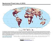
Development Threat Index
National Aeronautics and Space Administration —
The Development Threat Index data set is a terrestrial global, future development threat map based on combining these resources: agricultural expansion, urban... -
Federal
China Dimensions Data Collection: China County-Level Data from Provincial Economic Yearbooks, Keyed to 1:1M GIS Map
National Aeronautics and Space Administration —
The China County-Level Data on Provincial Economic Yearbooks, Keyed To 1:1M GIS Map consists of socioeconomic and boundary data for the administrative regions of... -
Federal
2001 Environmental Sustainability Index (ESI)
National Aeronautics and Space Administration —
The 2001 Environmental Sustainability Index (ESI) utilizes a refined methodology based on the 2000 Pilot ESI effort, to construct an index covering 122 countries that... -
Federal
Latin America and the Caribbean Population Time Series
National Aeronautics and Space Administration —
The Latin America and the Caribbean Population Time Series data set provides total population estimates using spatially consistent and comparable Units for Latin... -
Federal
2015 Urban Extents from VIIRS and MODIS for the Continental U.S. Using Machine Learning Methods NGDA
National Aeronautics and Space Administration —
The 2015 Urban Extents from VIIRS and MODIS for the Continental U.S. Using Machine Learning Methods data set models urban settlements in the Continental United States... -
Federal
Gridded Population of the World, Version 4 (GPWv4): Population Density, Revision 11
National Aeronautics and Space Administration —
The Gridded Population of the World, Version 4 (GPWv4): Population Density, Revision 11 consists of estimates of human population density (number of persons per... -
Federal
Global Database of Light-based Geospatial Income Inequality (LGII) Measures, Version 1
National Aeronautics and Space Administration —
The Global Database of Light-based Geospatial Income Inequality (LGII) Measures, Version 1 data set contains Gini-coefficients of inequality for 234 countries and... -
Federal
Global Subnational Infant Mortality Rates, Version 2.01
National Aeronautics and Space Administration —
The Global Subnational Infant Mortality Rates, Version 2.01 consist of Infant Mortality Rate (IMR) estimates for 234 countries and territories, 143 of which include...

Official websites use .gov
A
.gov website belongs to an official government
organization in the United States.
Secure .gov websites use HTTPS
A
lock (
) or https:// means you’ve safely connected to
the .gov website. Share sensitive information only on official,
secure websites.