
-
Federal
CARVE: L1 Spectral Radiances from Airborne FTS, Alaska, 2012-2015
National Aeronautics and Space Administration —
This data set contains Level 1 spectral radiance data collected using the Fourier Transform Spectrometer (FTS) during airborne campaigns over the Alaskan and Canadian... -
Federal
Leaf Reflectances: LICOR (OTTER)
National Aeronautics and Space Administration —
The variability of bi-directional spectral reflectance of cut conifer foliage between age classes, species and sites, measured by LICOR -
Federal
Bowen Ratio Surface Flux: KSU (FIFE)
National Aeronautics and Space Administration —
Assessing the effects of annual burning & topography on surface energy exchanges -
Federal
Satellite AVHRR Extracted Data (FIFE)
National Aeronautics and Space Administration —
Site specifice radiance, exoatmospheric reflectance & surface reflectance -
Federal
Net Radiation and Albedo from MODIS for Xingu River Basin, Brazil, 2000-2012 NGDA
National Aeronautics and Space Administration —
This dataset provides daily average land surface net radiation (Rnet) as an 8-day time series at approximately 0.5 km resolution for the upper Xingu River Basin in... -
Federal
NWS Daily Climatology Data: 1985 (SNF)
National Aeronautics and Space Administration —
Daily min, max, average temperature (F), precipitation (water equivalent in inches), and daily insolation (Langleys) for the Superior National Forest area as... -
Federal
Radiant Temp. Multiangle Data (FIFE)
National Aeronautics and Space Administration —
Surface temp. measured w/ Everest IRT, multiple angles & Eppley IR Radiometer -
Federal
Daymet: Daily Surface Weather Data on a 1-km Grid for North America, Version 4 R1
National Aeronautics and Space Administration —
This dataset provides Daymet Version 4 R1 data as gridded estimates of daily weather parameters for North America, Hawaii, and Puerto Rico. Daymet variables include... -
Federal
Global Forest Ecosystem Structure and Function Data For Carbon Balance Research
National Aeronautics and Space Administration —
A comprehensive global database has been assembled to quantify CO2 fluxes and pathways across different levels of integration (from photosynthesis up to net ecosystem... -
Federal
BOREAS RSS-02 Level-1b ASAS Image Data: At-sensor Radiance in BSQ Format
National Aeronautics and Space Administration —
The BOREAS RSS-02 team used the ASAS instrument, mounted on the NASA C-130 aircraft, to create at-sensor radiance images of various sites as a function of spectral... -
Federal
BOREAS/SRC AMS Suite A Surface Meteorological and Radiation Data: 1996
National Aeronautics and Space Administration —
Contains the data collected in 1996 by the AMS suite A instrument set operated by SRC and provided to BORIS. -
Federal
SE-590 Leaf Optical Prop. Data (FIFE)
National Aeronautics and Space Administration —
Leaf optical properties (reflectance & transmittance) from SE590 & LICOR -
Federal
ISLSCP II Ecosystem Rooting Depths NGDA
National Aeronautics and Space Administration —
The goal of this study was to predict the global distribution of plant rooting depths based on data about global aboveground vegetation structure and climate.... -
Federal
Bowen Ratio Surface Flux: UNL (FIFE)
National Aeronautics and Space Administration —
Latent & sensible heat flux by Bowen Ratio & aerodynamic characterization of vegetation -
Federal
SE-590 Reflectance & Radiances (FIFE)
National Aeronautics and Space Administration —
SE-590 reflectance factors and radiances measured from a helicopter -
Federal
Longwave Radiation Data: UNL (FIFE)
National Aeronautics and Space Administration —
Average incoming longwave radiation measured by University of Nebraska -
Federal
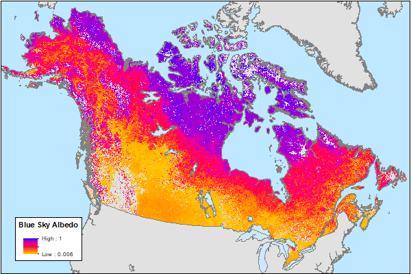
ABoVE: MODIS-Derived Daily Mean Blue Sky Albedo for Northern North America, 2000-2017 NGDA
National Aeronautics and Space Administration —
This dataset contains MODIS-derived daily mean shortwave blue sky albedo for northern North America (i.e., Canada and Alaska) and a set of quality control flags for... -
Federal
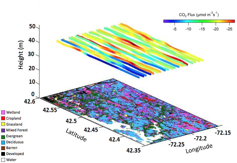
AirMOSS: L2 Airborne Carbon Flux at Selected AirMOSS Sites, 2012-2014
National Aeronautics and Space Administration —
This data set contains carbon flux measurements recorded by an aircraft at the Duke, Harvard, and Howland Forest sites during the summers of 2012-2014 as part of the... -
Federal
PARABOLA Data (FIFE)
National Aeronautics and Space Administration —
Sky & ground radiance values averaged to give equal intervals of viewing angles -
Federal
Optical Thickness Data: C-130 (FIFE)
National Aeronautics and Space Administration —
Airborne sun photometer data taken from C-130

Official websites use .gov
A
.gov website belongs to an official government
organization in the United States.
Secure .gov websites use HTTPS
A
lock (
) or https:// means you’ve safely connected to
the .gov website. Share sensitive information only on official,
secure websites.