
-
Federal
VIIRS NOAA-20 (JPSS-1) 375m, I-Band Active Fire Product NRT (Vector Data)
National Aeronautics and Space Administration —
Near real-time (NRT) NOAA-20 (formally JPSS-1) Visible Infrared Imaging Radiometer Suite (VIIRS) Active Fire detection product is based on the instrument's 375 m... -
Federal
Sounder SIPS: Suomi NPP CrIMSS Level 3 Comprehensive Quality Control Gridded Monthly CHART Normal Spectral Resolution V1
National Aeronautics and Space Administration —
The objective of this limited edition data collection is to examine products generated by the Climate Heritage AIRS Retrieval Technique (CHART) algorithm to analyze... -
Federal
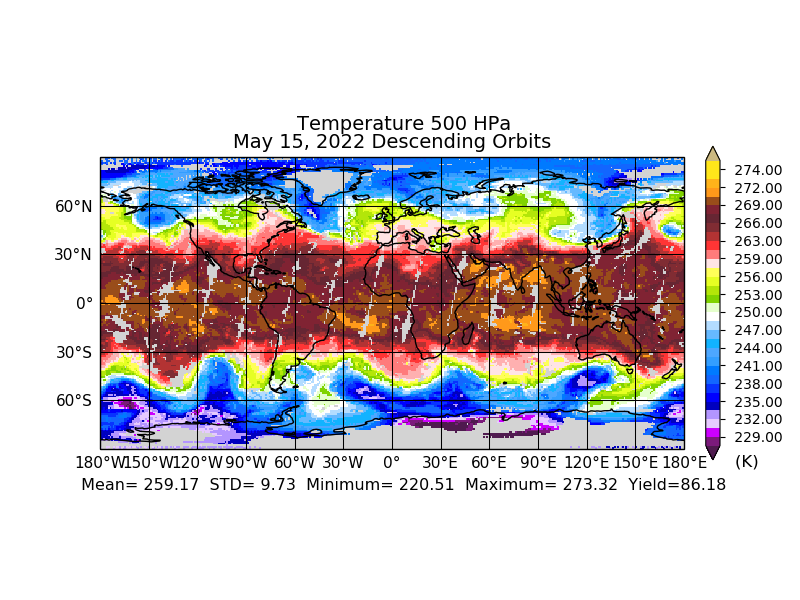
Sounder SIPS: JPSS-1 ATMS Level 3 RAMSES2 Standard Gridded Daily V3 at GES DISC
National Aeronautics and Space Administration —
This level 3 daily product is generated from the RAMSES (Retrieval Algorithm for Microwave Sounders in Earth Science) II algorithm.The RAMSES II algorithm is a... -
Federal
Sounder SIPS: Suomi NPP ATMS Level 3 RAMSES2 Standard Gridded Daily V3 at GES DISC
National Aeronautics and Space Administration —
This level 3 daily product is generated from the RAMSES (Retrieval Algorithm for Microwave Sounders in Earth Science) II algorithm.The RAMSES II algorithm is a... -
Federal
Sounder SIPS: Suomi NPP CrIMSS Level 3 Specific Quality Control Gridded Monthly CHART Normal Spectral Resolution V1
National Aeronautics and Space Administration —
The objective of this limited edition data collection is to examine products generated by the Climate Heritage AIRS Retrieval Technique (CHART) algorithm to analyze... -
Federal
MODIS/Terra Gap-Filled, Smoothed NDVI 8-Day L4 250m SIN Grid NGDA
National Aeronautics and Space Administration —
The MODIS/Terra Gap-Filled, Smoothed NDVI 8-Day L4 250m SIN Grid product, with short-name MOD09Q1G_NDVI is calculated from MODIS surface reflectance products (MOD09),... -
Federal
Sounder SIPS: Suomi NPP ATMS Level 3 RAMSES2 Standard Gridded Monthly V3 at GES DISC
National Aeronautics and Space Administration —
This level 3 monthly product is generated from the RAMSES (Retrieval Algorithm for Microwave Sounders in Earth Science) II algorithm.The RAMSES II algorithm is a... -
Federal
MODIS/Terra NDVI Phenology annual L4 250m SIN Grid NGDA
National Aeronautics and Space Administration —
The MODIS/Terra NDVI Phenology annual L4 250m SIN Grid product, with short-name MOD09Q1P_NDVI is a Gap-filled Smoothed NDVI created from the MOD09A1 8-day Surface... -
Federal
Sounder SIPS: Suomi NPP ATMS Level 2 RAMSES2 Standard: Atmosphere, precipitation and surface geophysical state, V3 (SNDRSNML2RMS ) at GES DISC
National Aeronautics and Space Administration —
This level 2 product is generated by the RAMSES (Retrieval Algorithm for Microwave Sounders in Earth Science) II algorithm.The RAMSES II algorithm is a microwave only... -
Federal
Sounder SIPS: JPSS-1 ATMS Level 2 RAMSES2 Standard: Atmosphere, precipitation and surface geophysical state V3 (SNDRJ1ML2RMS) at GES DISC
National Aeronautics and Space Administration —
This level 2 product is generated by the RAMSES (Retrieval Algorithm for Microwave Sounders in Earth Science II algorithm.The RAMSES II algorithm is a microwave only... -
Federal
Sounder SIPS: JPSS-1 ATMS Level 3 RAMSES2 Standard Gridded Monthly V3 at GES DISC
National Aeronautics and Space Administration —
This level 3 monthly product is generated from the RAMSES (Retrieval Algorithm for Microwave Sounders in Earth Science) II algorithm.The RAMSES II algorithm is a... -
Federal
MODIS/Terra Atmospherically Corrected Surface Reflectance 5-Min L2 Swath 250m, 500m, 1km NGDA
National Aeronautics and Space Administration —
The MODIS/Terra Atmospherically Corrected Surface Reflectance 5-Min L2 Swath 250m, 500m, 1km (MOD09) product is computed from the MODIS Level 1B land bands 1, 2, 3,... -
Federal
MODIS/Terra Land Surface Temperature/3-Band Emissivity 5-Min L2 1km NRT NGDA
National Aeronautics and Space Administration —
The MODIS/Terra Land Surface Temperature/3-Band Emissivity (LST&E) 5-Min L2 1km data product, short-name MOD21 is produced daily in five minute temporal... -
Federal
MODIS/Aqua Land Surface Temperature/3-Band Emissivity 5-Min L2 1km NRT NGDA
National Aeronautics and Space Administration —
The MODIS/Aqua Land Surface Temperature/3-Band Emissivity (LST&E) 5-Min L2 1km data product, short-name MYD21 is produced daily in five minute temporal increments... -
Federal
Sounder SIPS: Suomi NPP CrIMSS Level 3 Comprehensive Quality Control Gridded Monthly CLIMCAPS Full Spectral Resolution V2 at GES DISC
National Aeronautics and Space Administration —
WARNING: To users of the derived product “co_mmr_midtrop” (carbon monoxide mass mixing ratio to dry air [kg/kg] at ~500 hPa). This variable has a significant bias due... -
Federal
Sounder SIPS: AQUA AIRS IR + MW Level 3 CLIMCAPS: Specific Quality Control Gridded Monthly V2 at GES DISC
National Aeronautics and Space Administration —
WARNING: To users of the derived product “co_mmr_midtrop” (carbon monoxide mass mixing ratio to dry air [kg/kg] at ~500 hPa). This variable has a significant bias due... -
Federal
Sounder SIPS: JPSS-1 CrIS Level 3 Comprehensive Quality Control Gridded Monthly CLIMCAPS V2 (SNDRJ1IML3CMCCP) at GES DISC
National Aeronautics and Space Administration —
WARNING: To users of the derived product “co_mmr_midtrop” (carbon monoxide mass mixing ratio to dry air [kg/kg] at ~500 hPa). This variable has a significant bias due... -
Federal
MODIS/Aqua Atmospherically Corrected Surface Reflectance 5-Min L2 Swath 250m, 500m, and 1km NGDA
National Aeronautics and Space Administration —
The MODIS/Aqua Atmospherically Corrected Surface Reflectance 5-Min L2 Swath 250m, 500m, 1km (MYD09) product is computed from the MODIS Level 1B land bands 1, 2, 3, 4,... -
Federal
VIIRS (S-NPP) I Band 375 m Active Fire Product NRT (Vector data)
National Aeronautics and Space Administration —
Near real-time (NRT) Suomi National Polar-orbiting Partnership (Suomi NPP) Visible Infrared Imaging Radiometer Suite (VIIRS) Active Fire detection product is based on... -
Federal
VIIRS/NPP DNB BRDF/Albedo Albedo Daily L3 Global 1km SIN Grid V001
National Aeronautics and Space Administration —
The Suomi National Polar-Orbiting Partnership (Suomi NPP) NASA Visible Infrared Imaging Radiometer Suite (VIIRS) Day/Night Band (DNB) Bidirectional Reflectance...

Official websites use .gov
A
.gov website belongs to an official government
organization in the United States.
Secure .gov websites use HTTPS
A
lock (
) or https:// means you’ve safely connected to
the .gov website. Share sensitive information only on official,
secure websites.