
-
Federal
CORONA Satellite Photography 49 recent views
National Aeronautics and Space Administration —
On February 24, 1995, President Clinton signed an Executive Order, directing the declassification of intelligence imagery acquired by the first generation of United... -
Federal
Global Hyperspectral Imaging Spectral-library of Agricultural crops for Conterminous United States V001 24 recent views
National Aeronautics and Space Administration —
The Global Hyperspectral Imaging Spectral-library of Agricultural crops (GHISA) is a comprehensive compilation, collation, harmonization, and standardization of... -
Federal
NACP Integrated Wildland and Cropland 30-m Fuel Characteristics Map, U.S.A., 2010
National Aeronautics and Space Administration —
The data set provides a 30-m comprehensive fuelbed characteristics map for both the wildland and cropland areas of the conterminous United States (CONUS) for 2010.... -
Federal
NARSTO EPA Supersite (SS) Houston, Texas Air Quality Study 2000 (TexAQS2000) Department of Energy (DOE) G-1 Air Chemistry, Aerosol, and Met Data
National Aeronautics and Space Administration —
NARSTO_EPA_SS_HOUSTON_TEXAQS2000_DOE_G-1_DATA is North American Research Strategy for Tropospheric Ozone (NARSTO) Environmental Protection Agency (EPA) Supersite (SS)... -
Federal
NASA Landsat Data Collection
National Aeronautics and Space Administration —
The NASA Landsat Data Collection (NLDC) is a compilation of Landsat multispectral scanner (MSS) scenes and Landsat thematic mapper (TM) scenes. This compilation of... -
Federal
Neutrally buoyant float data for the SPURS-1 N. Atlantic field campaign
National Aeronautics and Space Administration —
The SPURS (Salinity Processes in the Upper Ocean Regional Study) project is an oceanographic process study and associated field program that aim to elucidate key... -
Federal
Surface Radiation Budget (SRB) Release 3.0 Shortwave 3 hourly monthly UTC data in netcdf format
National Aeronautics and Space Administration —
The data set contains monthly average/3-hourly (also calleddiurnally-resolved monthly average or just 'diurnal' for brevity) global fieldsof 11 shortwave (SW) surface... -
Federal
GPM GROUND VALIDATION AUTONOMOUS PARSIVEL UNIT (APU) MC3E V1
National Aeronautics and Space Administration —
The GPM Ground Validation Autonomous Parsivel Unit (APU) MC3E dataset was collected by the Autonomous Parsivel Unit (APU), which is an optical disdrometer that... -
Federal
NARSTO SOS99 Nashville WP-3D Orion Air Chemistry Data
National Aeronautics and Space Administration —
NARSTO_SOS99NASH_WP3D_CHEMISTRY_DATA is the North American Research Strategy for Tropospheric Ozone (NARSTO) SOS99 Nashville WP-3D Orion Air Chemistry Data product.... -
Federal
SCOAPE R/V Point Sur Data
National Aeronautics and Space Administration —
SCOAPE_RVPointSur_Data is the data collected from instruments onboard the University of Southern Mississippi’s Research Vessel (R/V) Point Sur during the Satellite... -
Federal
LISTOS Ground Data at Miscellaneous Ground Sites
National Aeronautics and Space Administration —
LISTOS_Ground_Other_Data is the Long Island Sound Tropospheric Ozone Study (LISTOS) ground site data collected at a collection of ground sites during the LISTOS field... -
Federal
MACPEX Satellite Ancillary Data
National Aeronautics and Space Administration —
MACPEX_Satellite_AircraftInSitu_WB57_Data is the supplementary satellite ancillary data collection during the Mid-latitude Airborne Cirrus Properties Experiment... -
Federal
LISTOS Rutgers Ground Site Data
National Aeronautics and Space Administration —
LISTOS_Ground_Rutgers_Data is the Long Island Sound Tropospheric Ozone Study (LISTOS) Rutgers ground site data collected during the LISTOS field campaign. This... -
Federal
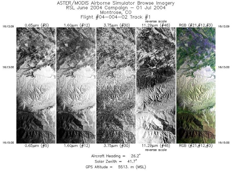
MASTER: Geological substrate mapping, Utah-Colorado, June, 2004
National Aeronautics and Space Administration —
This dataset includes Level 1B (L1B) data products from the MODIS/ASTER Airborne Simulator (MASTER) instrument. The spectral data were collected during two flights... -
Federal
Meteorology and soil temperatures, Hot Weather Creek, Ellesmere Island, NWT, Canada, Version 1
National Aeronautics and Space Administration —
The instrumentation was installed in June 1988 and was initially maintained by the Arctic Adaptation Division Canadian Climate Centre, Atmospheric Environment Service... -
Federal
Distributed Data Mining in Peer-to-Peer Networks
National Aeronautics and Space Administration —
Peer-to-peer (P2P) networks are gaining popularity in many applications such as file sharing, e-commerce, and social networking, many of which deal with rich,... -
Federal
Burn Scar - Corrected Reflectance (VIIRS / Suomi-NPP)
National Aeronautics and Space Administration —
This visualization represents a "false color" band combination (M11-I2-I1 | Red-Green-Blue) of data collected by the VIIRS instrument on the Suomi-NPP satellite and... -
Federal
MACPEX WB-57 Aircraft In-situ Meteorology and Navigational Data
National Aeronautics and Space Administration —
MACPEX_MetNav_AircraftInSitu_WB57_Data is the in-situ meteorology and navigational data collection during the Mid-latitude Airborne Cirrus Properties Experiment... -
Federal
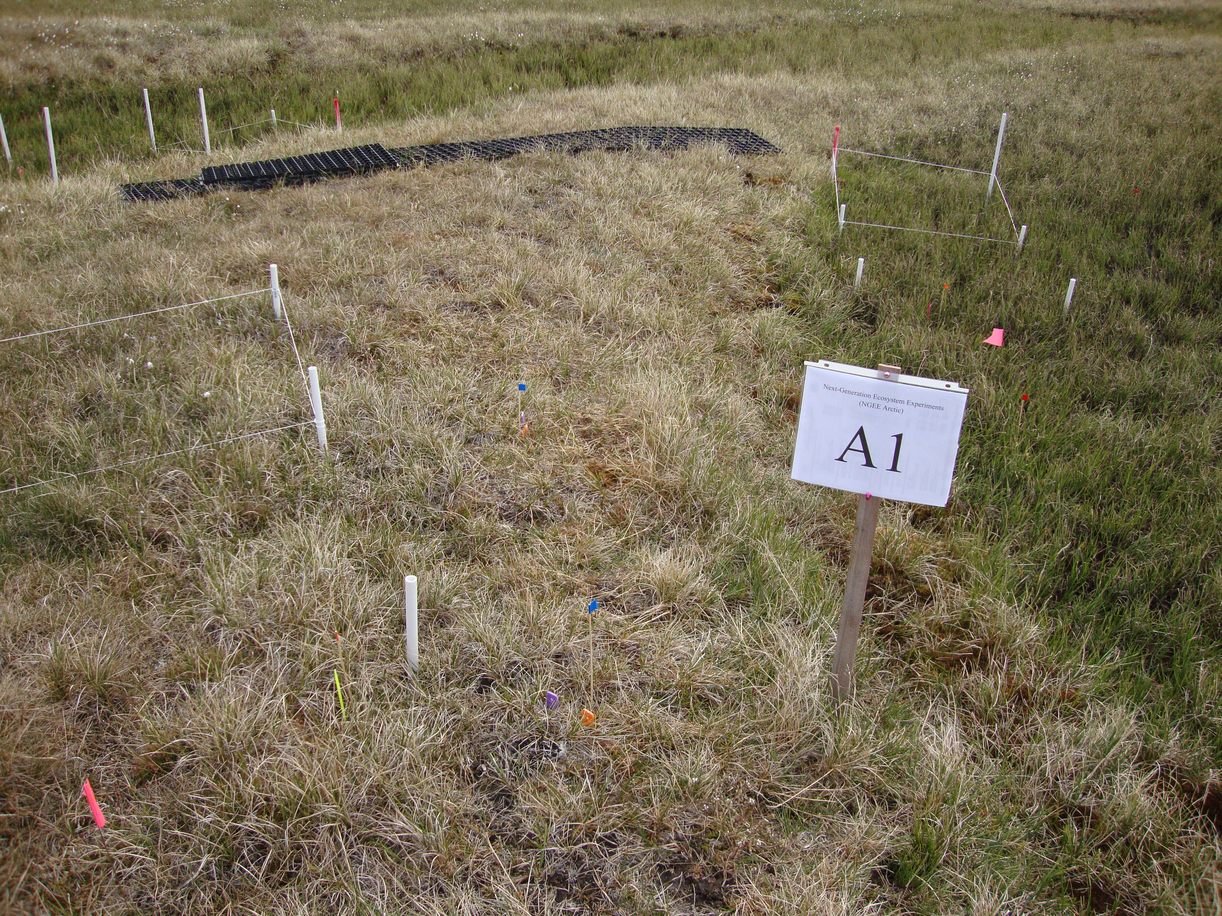
Arctic Vegetation Plots for NGEE-Arctic at Barrow, Alaska, 2012
National Aeronautics and Space Administration —
This data set provides vegetation cover and environmental plot data collected on the Barrow Environmental Observatory (BEO), Barrow, Alaska in 2012. Forty-eight 1 x 1...

Official websites use .gov
A
.gov website belongs to an official government
organization in the United States.
Secure .gov websites use HTTPS
A
lock (
) or https:// means you’ve safely connected to
the .gov website. Share sensitive information only on official,
secure websites.