

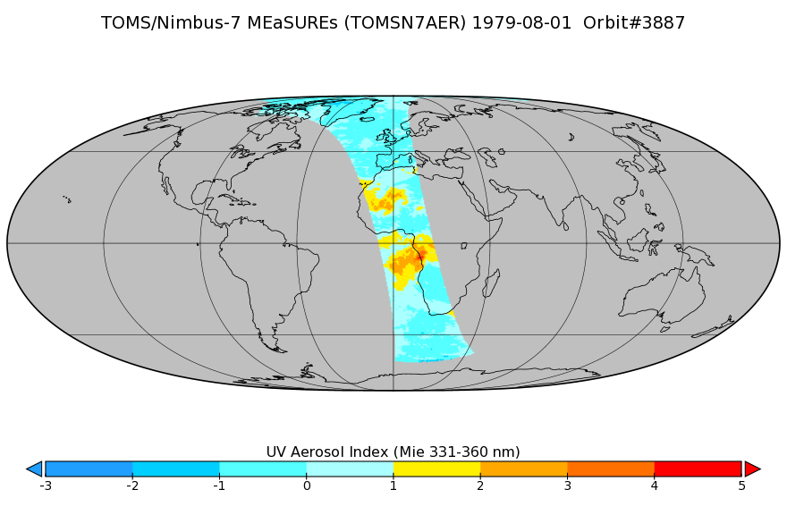
TOMS/N7 Near UV Aerosol Index and LER 1-Orbit L2 50x50 km
Access & Use Information
Public: This dataset is intended for public access and use.
License: No license information was provided. If this work was prepared by an officer or employee of the United States government as part of that person's official duties it is considered a U.S. Government Work.
Downloads & Resources
-
Data Information (PNG)PNG
TIROS4L1FMRT_Sample.png
-
Data Information (Unknown Format)BIN
TIROS4L1FMRT.001
-
Data Information (Unknown Format)BIN
-
Data Information (PDF)PDF
README.TIROS4FMRT.001.pdf
-
Data Information (PDF)PDF
TirosIV_CatalogandUserManual.pdf
-
Data Information (XLSX)EXCEL
Tiros_Inventory.xlsx
-
Data Information (HTML)HTML
TIROS4L1FMRT_001.html
-
Landing PageLanding Page
Dates
| Metadata Created Date | April 11, 2025 |
|---|---|
| Metadata Updated Date | October 30, 2025 |
Metadata Source
- Data.json Data.json Metadata
Harvested from NASA Data.json
Additional Metadata
| Resource Type | Dataset |
|---|---|
| Metadata Created Date | April 11, 2025 |
| Metadata Updated Date | October 30, 2025 |
| Publisher | NASA/GSFC/SED/ESD/TISL/GESDISC |
| Maintainer | |
| Identifier | 10.5067/MEASURES/AER/DATA201 |
| Data Last Modified | 2025-09-11 |
| Category | Earth Science |
| Public Access Level | public |
| Bureau Code | 026:00 |
| Metadata Context | https://project-open-data.cio.gov/v1.1/schema/catalog.jsonld |
| Schema Version | https://project-open-data.cio.gov/v1.1/schema |
| Catalog Describedby | https://project-open-data.cio.gov/v1.1/schema/catalog.json |
| Harvest Object Id | f8a2a74c-d89a-4852-82a5-41f2439de355 |
| Harvest Source Id | 58f92550-7a01-4f00-b1b2-8dc953bd598f |
| Harvest Source Title | NASA Data.json |
| Homepage URL | https://docserver.gesdisc.eosdis.nasa.gov/public/project/Images/TOMSN7AER_002.png |
| Old Spatial | "GEODETIC",{"WestBoundingCoordinate":-180,"NorthBoundingCoordinate":90,"EastBoundingCoordinate":180,"SouthBoundingCoordinate":-90} |
| Program Code | 026:000 |
| Source Datajson Identifier | True |
| Source Hash | b7c496339c8fa86c706799db4455d850061af7b5f7002a9530a7624185c79d1f |
| Source Schema Version | 1.1 |
| Spatial | |
| Temporal | 1978-11-02/1978-11-02 |
Didn't find what you're looking for? Suggest a dataset here.