

MODIS/Terra Land Surface Temperature/Emissivity Monthly L3 Global 0.05Deg CMG V061
Access & Use Information
Public: This dataset is intended for public access and use.
License: No license information was provided. If this work was prepared by an officer or employee of the United States government as part of that person's official duties it is considered a U.S. Government Work.
Downloads & Resources
-
Data Information (Unknown Format)BIN
-
Data Information (HTML)HTML
MOD11C3.061
-
Data Information (Unknown Format)BIN
-
Data Information (PDF)PDF
MOD11_User_Guide_V61.pdf
-
Data Information (PDF)PDF
MOD11_ATBD.pdf
-
Data Information (Unknown Format)BIN
-
Data Information (HTML)HTML
MODLAND_val.html
-
Data Information (Unknown Format)BIN
-
Data Information (HTML)HTML
contents.html
-
Data Information (JPEG)JPEG
BROWSE.MOD11C3.A2024122.061.2024162162404.1.jpg
-
Data Information (Unknown Format)BIN
-
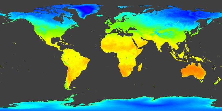
Data Information (JPEG)JPEG
MODIS_Terra_L3_Land_Surface_Temp_Monthly_Day.jpg
-
Landing PageLanding Page
Dates
| Metadata Created Date | April 11, 2025 |
|---|---|
| Metadata Updated Date | September 19, 2025 |
Metadata Source
- Data.json Data.json Metadata
Harvested from NASA Data.json
Additional Metadata
| Resource Type | Dataset |
|---|---|
| Metadata Created Date | April 11, 2025 |
| Metadata Updated Date | September 19, 2025 |
| Publisher | LP DAAC;NASA/GSFC/SED/ESD/TISL/MODAPS |
| Maintainer | |
| Identifier | 10.5067/MODIS/MOD11C3.061 |
| Data Last Modified | 2025-09-11 |
| Category | Earth Science |
| Public Access Level | public |
| Bureau Code | 026:00 |
| Metadata Context | https://project-open-data.cio.gov/v1.1/schema/catalog.jsonld |
| Schema Version | https://project-open-data.cio.gov/v1.1/schema |
| Catalog Describedby | https://project-open-data.cio.gov/v1.1/schema/catalog.json |
| Harvest Object Id | e74c4f03-818b-4601-b4c9-f5641252a9e3 |
| Harvest Source Id | 58f92550-7a01-4f00-b1b2-8dc953bd598f |
| Harvest Source Title | NASA Data.json |
| Homepage URL | https://search.earthdata.nasa.gov/search?q=C2565788897-LPCLOUD |
| Old Spatial | "CARTESIAN",{"NorthBoundingCoordinate":90,"WestBoundingCoordinate":-180,"EastBoundingCoordinate":180,"SouthBoundingCoordinate":-90} |
| Program Code | 026:000 |
| Source Datajson Identifier | True |
| Source Hash | d46e9c9f400591da2a38a75c1aa034eebb75008e7ea64f4cf2a74b922862b791 |
| Source Schema Version | 1.1 |
| Spatial | |
| Temporal | 2000-02-01/2000-02-01 |
Didn't find what you're looking for? Suggest a dataset here.