

H11182: NOS Hydrographic Survey , Port Valdez and Valdez Harbor, Alaska, 2002-09-21
Access & Use Information
Downloads & Resources
-
H11182.xmlXML
Survey metadata record.
-
H11182_10m_UTM06NAD83.tfw.gz
NOAA/NOS TIFF survey world file
-
H11182.tn.pdfPDF
NOAA/NOS Tide Note in PDF format
-
H11182_10m_UTM06NAD83.jpgJPEG
NOAA/NOS JPEG survey image
-
H11182.xyz.gzXYZ
NOAA/NOS ASCII XYZ sounding data
-
H11182_10m_UTM06NAD83.tif.gzTIFF
NOAA/NOS TIFF survey image
-
H11182_h93.htmHTML
NOAA/NOS HYD93 format ASCII header metadata (see...
-
H11182.pdfPDF
NOAA/NOS Descriptive Report in PDF format
-
OPR-P151-RA-02(H11182).jpgJPEG
Project Sketch in JPEG format
-
H11182.tz.pdfPDF
NOAA/NOS Tide Zone in PDF format
-
H11182_10m_DecDegNAD83.txt.gzTEXT
NOAA/NOS ASCII YXZ grid
-
H11182.a93.gz
NOAA/NOS HYD93 format ASCII sounding data (see...
-
H11182_10m.sd.gzchemical/x-mdl-sdfile
NOAA/NOS Fledermaus 3D visualization file
-
H11182 soundings from point store database
NOAA/NOS ASCII XYZ sounding data from the Point Store database
-
H11182_10m_UTM06NAD83.jpw
NOAA/NOS JPEG survey world file
-
H11182_10m_UTM06NAD83.txt.gzTEXT
NOAA/NOS ASCII YXZ grid
-
H11182.tif.gzTIFF
NOAA/NOS Smooth Sheet survey image
-
Global Change Master Directory (GCMD) Keywords
16 views
The information provided on this page seeks to define how the GCMD Keywords...
-
Global Change Master Directory (GCMD) Keywords
16 views
The information provided on this page seeks to define how the GCMD Keywords...
-
Global Change Master Directory (GCMD) Keywords
16 views
The information provided on this page seeks to define how the GCMD Keywords...
-
Global Change Master Directory (GCMD) Keywords
16 views
The information provided on this page seeks to define how the GCMD Keywords...
-
Getty Thesaurus of Geographic Names Online PageHTML
This page provides an interface to search the Getty Thesaurus of Geographic...
Dates
| Metadata Date | April 21, 2021 |
|---|---|
| Metadata Created Date | September 24, 2021 |
| Metadata Updated Date | September 24, 2021 |
| Reference Date(s) | September 21, 2002 (publication) |
| Frequency Of Update | notPlanned |
Metadata Source
- ISO-19139 ISO-19139 Metadata
Harvested from NESDIS/NGDC/MGG/NOS/H10001-H12000
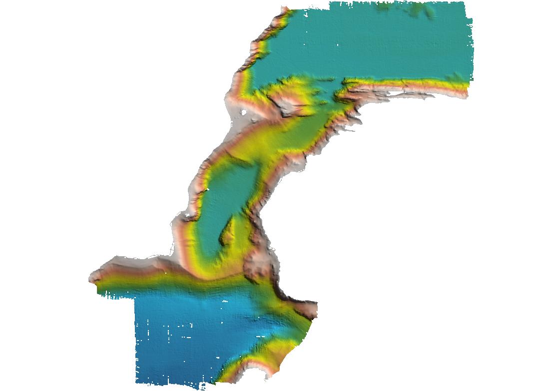
Graphic Preview
.jpg "Graphic Preview")
Additional Metadata
| Resource Type | |
|---|---|
| Metadata Date | April 21, 2021 |
| Metadata Created Date | September 24, 2021 |
| Metadata Updated Date | September 24, 2021 |
| Reference Date(s) | September 21, 2002 (publication) |
| Responsible Party | DOC/NOAA/NOS/OCS/HSD > Hydrographic Surveys Division, Office of Coast Survey, National Ocean Service, NOAA, U.S. Department of Commerce (Point of Contact) |
| Contact Email | |
| Guid | gov.noaa.nos.h10001-h12000:H11182 |
| Access Constraints | Distribution liability: NOAA and NCEI make no warranty, expressed or implied, regarding these data, nor does the fact of distribution constitute such a warranty. NOAA and NCEI cannot assume liability for any damages caused by any errors or omissions in these data. If appropriate, NCEI can only certify that the data it distributes are an authentic copy of the records that were accepted for inclusion in the NCEI archives. |
| Bbox East Long | -146.582114999945 |
| Bbox North Lat | 61.1010660000087 |
| Bbox South Lat | 61.0312380003123 |
| Bbox West Long | -146.726006000434 |
| Coupled Resource | |
| Frequency Of Update | notPlanned |
| Graphic Preview File | https://data.ngdc.noaa.gov/platforms/ocean/nos/coast/H10001-H12000/H11182/project_sketches/OPR-P151-RA-02(H11182).jpg |
| Harvest Object Id | 3135c239-4dfa-411e-a8dc-98c036db02bf |
| Harvest Source Id | 497230c9-3e97-4f06-992b-417c1d6b4afb |
| Harvest Source Title | NESDIS/NGDC/MGG/NOS/H10001-H12000 |
| Licence | Not to be used for navigation. Although these data are of high quality and useful for planning and modeling purposes, they are not suitable for navigation. For navigation, please refer to the NOS nautical chart series., These data are considered raw and have not been subjected to the NOAA's quality control or quality assurance procedures. They are released for limited public use as preliminary data to be used only with appropriate caution. NOAA cannot assume liability for any damages caused by any errors or omissions in the data, nor as a result of the failure of the data to function on a particular system. NOAA makes no warranty, expressed or implied, nor does the fact of distribution constitute such a warranty. |
| Metadata Language | eng |
| Metadata Type | geospatial |
| Old Spatial | {"type": "Polygon", "coordinates": [[[-146.726006, 61.0312380003], [-146.582115, 61.0312380003], [-146.582115, 61.101066], [-146.726006, 61.101066], [-146.726006, 61.0312380003]]]} |
| Progress | completed |
| Spatial Data Service Type | |
| Spatial Reference System | urn:ogc:def:crs:EPSG::4269 |
| Spatial Harvester | True |
| Temporal Extent Begin | 2002-09-13 |
| Temporal Extent End | 2002-09-21 |
Didn't find what you're looking for? Suggest a dataset here.