
-
Federal
Shoreline Mapping Program of Seward, AK, AK1609-CM-N NGDA
National Oceanic and Atmospheric Administration, Department of Commerce —
These data provide an accurate high-resolution shoreline compiled from imagery of Seward, AK . This vector shoreline data is based on an office interpretation of... -
State
Updated tsunami inundation maps for Seward and northern Resurrection Bay, Alaska
State of Alaska —
Updated tsunami inundation maps for Seward and northern Resurrection Bay, Alaska, Report of Investigation 2022-3, updates the previous tsunami hazard assessment for... -
Federal
Exit and Paradise Creek Fluvial Features, 2012
Department of the Interior —
This dataset presents delineations of the braid plains of Exit and Paradise Creeks in Kenai Fjords National Park, Alaska for 2012 conditions. A braid plain can be... -
Federal
National Status and Trends: Mussel Watch Program - Resurrection Bay Database
National Oceanic and Atmospheric Administration, Department of Commerce —
In response to the growing concerns among Native communities about the safety of subsistence shellfish, this project assessed the health risks associated with... -
Federal
Monthly and annual mean seawater temperature, salinity and density from 26 tide gauge sites during 1855-1993 (NCEI Accession 0000817)
National Oceanic and Atmospheric Administration, Department of Commerce —
Tidal observers at primary tide gauges of the United States Coast and Geodetic Survey (now the NOAA National Ocean Service) routinely measured seawater temperature... -
Federal
Exit Creek Particle Size, June 2013
Department of the Interior —
This dataset presents particle size data collected at the surface of gravel bars along Exit Creek, a stream draining Exit Glacier in Kenai Fjords National Park,... -
Federal
Exit and Paradise Creek Drainage Area Boundaries, Alaska, 2012
Department of the Interior —
This dataset contains drainage area boundaries for Exit Creek and Paradise Creek in Kenai Fjords National Park, Alaska. A drainage area boundary identifies the land... -
Federal
Little Ice Age Maximum Glacier Extent, Exit and Paradise Glaciers, Alaska
Department of the Interior —
This dataset is a single polyline file that depicts the boundary of the Little Ice Age maximum advance of the terminus of Exit and Paradise Glaciers. The data were... -
State
Photogrammetry-derived digital surface model and orthoimagery of land areas near Resurrection Bay, Alaska
State of Alaska —
The State of Alaska Division of Geological & Geophysical Surveys (DGGS) produced a digital surface model (DSM) and an orthorectified aerial optical image mosaic... -
Federal
H08855: NOS Hydrographic Survey , Resurrection Bay, Alaska, 1965-08-31
National Oceanic and Atmospheric Administration, Department of Commerce —
The National Oceanic and Atmospheric Administration (NOAA) has the statutory mandate to collect hydrographic data in support of nautical chart compilation for safe... -
Federal
H08822: NOS Hydrographic Survey , Resurrection Bay, Alaska, 1966-05-23
National Oceanic and Atmospheric Administration, Department of Commerce —
The National Oceanic and Atmospheric Administration (NOAA) has the statutory mandate to collect hydrographic data in support of nautical chart compilation for safe... -
Federal
Common Eider Blood Chemistry Data, Alaska, 2004-2006
Department of the Interior —
This data set contains information on blood chemistry and hematological parameters of captive Pacific Common Eiders (Somateria mollissima v-nigrum) for reference... -
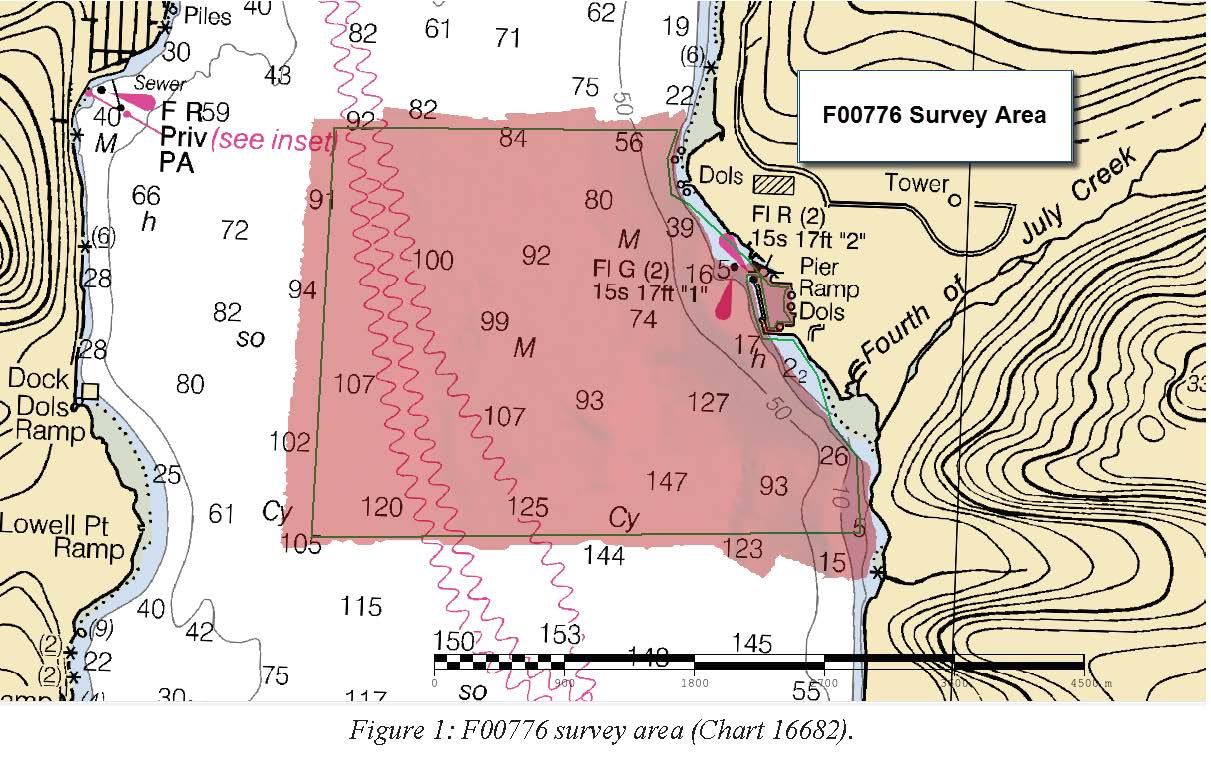
Federal
F00776: NOS Hydrographic Survey , 2019-06-05
National Oceanic and Atmospheric Administration, Department of Commerce —
The National Oceanic and Atmospheric Administration (NOAA) has the statutory mandate to collect hydrographic data in support of nautical chart compilation for safe... -
State
Photogrammetry-derived digital surface model and orthoimagery of land areas near Resurrection Bay, Alaska
State of Alaska —
The State of Alaska Division of Geological & Geophysical Surveys (DGGS) produced a digital surface model (DSM) and an orthorectified aerial optical image mosaic... -
Federal
TIGER/Line Shapefile, 2021, County, Seward County, KS, All Roads
U.S. Census Bureau, Department of Commerce —
The TIGER/Line shapefiles and related database files (.dbf) are an extract of selected geographic and cartographic information from the U.S. Census Bureau's Master... -
Federal
TIGER/Line Shapefile, 2021, County, Seward County, NE, All Roads
U.S. Census Bureau, Department of Commerce —
The TIGER/Line shapefiles and related database files (.dbf) are an extract of selected geographic and cartographic information from the U.S. Census Bureau's Master... -
Federal
Exit Creek Water Surface Survey, June 2013
Department of the Interior —
This dataset consists of survey data from a longitudinal profile of water surface surveyed June 23-24, 2013 at Exit Creek, a stream draining Exit Glacier in Kenai... -
Federal
TIGER/Line Shapefile, 2023, County, Seward County, KS, Feature Names Relationship File
U.S. Census Bureau, Department of Commerce —
The TIGER/Line shapefiles and related database files (.dbf) are an extract of selected geographic and cartographic information from the U.S. Census Bureau's Master... -
Federal
TIGER/Line Shapefile, 2023, County, Seward County, NE, All Lines
U.S. Census Bureau, Department of Commerce —
The TIGER/Line shapefiles and related database files (.dbf) are an extract of selected geographic and cartographic information from the U.S. Census Bureau's Master... -
State
Tsunami inundation maps of Seward and northern Resurrection Bay, Alaska
State of Alaska —
The purpose of this study is to evaluate tsunami hazard for the community of Seward and northern Resurrection Bay area, Alaska. This report will provide guidance to...

Official websites use .gov
A
.gov website belongs to an official government
organization in the United States.
Secure .gov websites use HTTPS
A
lock (
) or https:// means you’ve safely connected to
the .gov website. Share sensitive information only on official,
secure websites.