
-
Federal
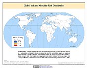
Global Volcano Mortality Risks and Distribution 10 recent views
National Aeronautics and Space Administration —
Global Volcano Mortality Risks and Distribution is a 2.5 minute grid representing global volcano mortality risks. The data set was constructed using historical... -
Federal
Global Population Density Grid Time Series Estimates
National Aeronautics and Space Administration —
The Global Population Density Grid Time Series Estimates provide a back-cast time series of population density grids based on the year 2000 population grid from... -
Federal
China Dimensions Data Collection: China County-Level Data on Population (Census) and Agriculture, Keyed to 1:1M GIS Map
National Aeronautics and Space Administration —
The China County-Level Data on Population (Census) and Agriculture, Keyed To 1:1M GIS Map consists of census, agricultural economic, and boundary data for the... -
Federal
Spatial Data from the 2011 India Census
National Aeronautics and Space Administration —
The Spatial Data from the 2011 India Census contains gridded estimates of India population at a resolution of 1 kilometer along with two spatial renderings of urban... -
Federal
Georeferenced Population Datasets of Mexico (GEO-MEX): Urban Place GIS Coverage of Mexico
National Aeronautics and Space Administration —
The Urban Place GIS Coverage of Mexico is a vector based point Geographic Information System (GIS) coverage of 696 urban places in Mexico. Each Urban Place is... -
Federal
Georeferenced Population Datasets of Mexico (GEO-MEX): Population Database of Mexico
National Aeronautics and Space Administration —
The Population Database of Mexico contains geographically referenced population data for Mexican states, municipalities and localities from the 1990 Mexican... -
Federal
Archive of Census Related Products (ACRP): 1990 Enhanced Migration Files
National Aeronautics and Space Administration —
The 1990 Enhanced Migration Files portion of the Archive of Census Related Products (ACRP) contains migration data derived from the U.S. Census Bureau's Summary Tape... -
Federal
Archive of Census Related Products (ACRP): 1990 SAS Transport Files
National Aeronautics and Space Administration —
The 1990 SAS Transport Files portion of the Archive of Census Related Products (ACRP) contains housing and population data from the U.S. Census Bureau's 1990 Summary... -
Federal
VIIRS Plus DMSP Change in Lights (VIIRS+DMSP dLIGHT)
National Aeronautics and Space Administration —
The VIIRS Plus DMSP Change in Lights (VIIRS+DMSP dLIGHT) data set fuses nighttime lights imagery from the U.S. Air Force Defense Meteorological Satellite Program... -
Federal
Public Use Microdata Samples (PUMS)
National Aeronautics and Space Administration —
The Public Use Microdata Samples (PUMS) are computer-accessible files containing records for a sample of housing Units, with information on the characteristics of... -
Federal
Global 15 x 15 Minute Grids of the Downscaled Population Based on the SRES B2 Scenario, 1990 and 2025
National Aeronautics and Space Administration —
The Global 15x15 Minute Grids of the Downscaled Population Based on the Special Report on Emissions Scenarios (SRES) B2 Scenario, 1990 and 2025, are geospatial... -
Federal
Global High Resolution Daily Extreme Urban Heat Exposure (UHE-Daily), 1983-2016
National Aeronautics and Space Administration —
The Global High Resolution Daily Extreme Urban Heat Exposure (UHE-Daily), 1983-2016 data set contains a high-resolution, longitudinal global record of geolocated... -
Federal
Global Population Count Grid Time Series Estimates
National Aeronautics and Space Administration —
The Global Population Count Grid Time Series Estimates provide a back-cast time series of population grids based on the year 2000 population grid from SEDAC's Global... -
Federal
Gridded Population of the World, Version 3 (GPWv3): Population Density Grid
National Aeronautics and Space Administration —
The Gridded Population of the World, Version 3 (GPWv3): Population Density Grid consists of estimates of human population for the years 1990, 1995, and 2000 by 2.5... -
Federal
Gridded Population of the World, Version 4 (GPWv4): Population Density, Revision 11
National Aeronautics and Space Administration —
The Gridded Population of the World, Version 4 (GPWv4): Population Density, Revision 11 consists of estimates of human population density (number of persons per... -
Federal
Global Subnational Infant Mortality Rates, Version 2.01
National Aeronautics and Space Administration —
The Global Subnational Infant Mortality Rates, Version 2.01 consist of Infant Mortality Rate (IMR) estimates for 234 countries and territories, 143 of which include... -
Federal
U.S. Census Grids (Summary File 1), 1990: Metropolitan Statistical Areas
National Aeronautics and Space Administration —
The U.S. Census Grids (Summary File 1), 1990: Metropolitan Statistical Areas data set contains grids of demographic and socioeconomic data from the year 1990 U.S.... -
Federal
Georeferenced U.S. County-Level Population Projections, Total and by Sex, Race and Age, Based on the SSPs, 2020-2100
National Aeronautics and Space Administration —
The Georeferenced U.S. County-Level Population Projections, Total and by Sex, Race and Age, Based on the SSPs, 2020-2100 consists of county-level population...

Official websites use .gov
A
.gov website belongs to an official government
organization in the United States.
Secure .gov websites use HTTPS
A
lock (
) or https:// means you’ve safely connected to
the .gov website. Share sensitive information only on official,
secure websites.