
-
Federal
Fisheries One Stop Shop Public Data 2009 - Present
National Oceanic and Atmospheric Administration, Department of Commerce —
The purpose of the Fisheries One-Stop-Shop (FOSS) is to make fisheries dependent information readily available to fisheries managers, scientists and the American... -
Federal
Benthic Habitats and Surficial Geology of Apalachicola Bay, Florida 2006 Geodatabase
National Oceanic and Atmospheric Administration, Department of Commerce —
These data were collected under a cooperative mapping program between the U.S. Geological Survey (USGS), the National Oceanic and Atmospheric Administration Office... -
Federal
Sensitivity of Coastal Environments and Wildlife to Spilled Oil: Puget Sound and Strait of Juan de Fuca, Washington: HABITATS (Habitat Polygons)
National Oceanic and Atmospheric Administration, Department of Commerce —
This data set contains sensitive biological resource data for marine and estuarine vegetation in Puget Sound and Strait of Juan de Fuca, Washington. Vector polygons... -
Federal
Sensitivity of Coastal Environments and Wildlife to Spilled Oil: Hudson River: SOCECON (Socioeconomic Resource Points and Lines)
National Oceanic and Atmospheric Administration, Department of Commerce —
This data set contains human-use resource data for marinas, boat ramps, locks and dams, water intake sites, archaeological sites, U.S. Coast Guard stations,... -
Federal
Benthic Habitats and Surficial Geology of Apalachicola Bay, Florida 2006 Geoform
National Oceanic and Atmospheric Administration, Department of Commerce —
These data were collected under a cooperative mapping program between the U.S. Geological Survey (USGS), the National Oceanic and Atmospheric Administration Office... -
Federal
2006 Florida LiDAR: Escambia, Santa Rosa, and Walton Counties
National Oceanic and Atmospheric Administration, Department of Commerce —
ESCAMBIA: The Light Detection and Ranging (LiDAR) LAS dataset is a survey of select areas within Escambia County, Florida. These data were produced for Dewberry and... -
Federal
ASV_SEISMICSHOT500 - Shot Points at 500 Shot Intervals for Seismic Data Collected with Autonomous Surface Vehicle (ASV) IRIS in Apalachicola Bay and St. George Sound, FL.
National Oceanic and Atmospheric Administration, Department of Commerce —
These data were collected under a cooperative mapping program between the U.S. Geological Survey (USGS), the National Oceanic and Atmospheric Administration Office... -
Federal
Sensitivity of Coastal Environments and Wildlife to Spilled Oil: Central California: INVERT (Invertebrate Polygons)
National Oceanic and Atmospheric Administration, Department of Commerce —
This data set contains sensitive biological resource data for marine, intertidal/subtidal, and terrestrial invertebrate species in Central California. Vector polygons... -
Federal
Sensitivity of Coastal Environments and Wildlife to Spilled Oil: Puget Sound and Strait of Juan de Fuca, Washington: HABITATL (Habitat Lines)
National Oceanic and Atmospheric Administration, Department of Commerce —
This data set contains sensitive biological resource data for marine and estuarine vegetation in Puget Sound and Strait of Juan de Fuca, Washington. Vector lines in... -
Federal
Sensitivity of Coastal Environments and Wildlife to Spilled Oil: Puget Sound and Strait of Juan de Fuca, Washington: FISHL (Fish Lines)
National Oceanic and Atmospheric Administration, Department of Commerce —
This data set contains sensitive biological resource data for marine, estuarine, and anadromous fish in Puget Sound and Strait of Juan de Fuca, Washington. Vector... -
Federal
NOAA TIFF Image - 3x3m Multibeam Backscatter, US Virgin Islands - Vieques Island (South Bank) - Project NF-09-01 - (2009), UTM 20N NAD83
National Oceanic and Atmospheric Administration, Department of Commerce —
This dataset contains a GeoTIFF with 3x3 meter cell size representing the backscatter or intensity of sound returned from the seafloor on the bank/shelf escarpment... -
Federal
Sensitivity of Coastal Environments and Wildlife to Spilled Oil: Central California: REPTILEL (Reptile and Amphibian Lines)
National Oceanic and Atmospheric Administration, Department of Commerce —
This data set contains sensitive biological resource data for amphibians and reptiles in Central California. Vector lines in this data set represent general stream... -
Federal
National Marine Recreational Fishing Expenditure Survey 2006
National Oceanic and Atmospheric Administration, Department of Commerce —
Marine recreational fishing is a popular pastime across the United States that generates significant economic impacts to both local economies and to the nation. In... -
Federal
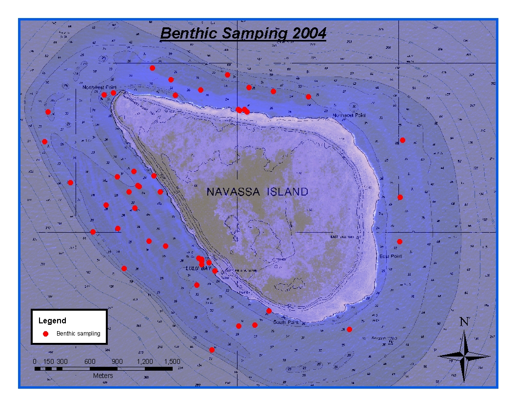
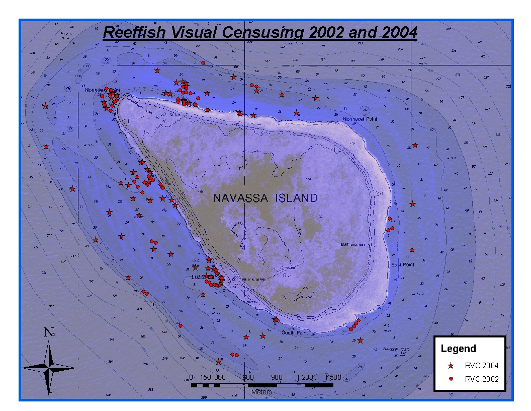
CRCP-Navassa reef assessment
National Oceanic and Atmospheric Administration, Department of Commerce —
Episodic cruises ( every 2 years) were conducted to perform assessments of Navassa Island coral reef resources including reeffish visual census, benthic reef... -
Federal
Meso-American System Larval Transport Ecology (CRCP)
National Oceanic and Atmospheric Administration, Department of Commerce —
Reef fish populations are part of one of the most complex ecosystems in the marine environment. They are also the most heavily exploited part of the ecosystem and... -
Federal
Cold Core Ring / Mesoscale Eddy Scombrid Habitat Ecological Study (MESHS)
National Oceanic and Atmospheric Administration, Department of Commerce —
The coupling of physical, biological, and fisheries oceanography is requisite for the proper assessment and description of these features as spawning and nursery... -
Federal
Myrtle Beach, South Carolina Tsunami Forecast Grids for MOST Model
National Oceanic and Atmospheric Administration, Department of Commerce —
The Myrtle Beach, South Carolina Forecast Model Grids provides bathymetric data strictly for tsunami inundation modeling with the Method of Splitting Tsunami (MOST)... -
Federal
Seward, Alaska Tsunami Forecast Grids for MOST Model
National Oceanic and Atmospheric Administration, Department of Commerce —
The Seward, Alaska Forecast Model Grids provides bathymetric data strictly for tsunami inundation modeling with the Method of Splitting Tsunami (MOST) model. MOST is... -
Federal
Sitka, Alaska Tsunami Forecast Grids for MOST Model
National Oceanic and Atmospheric Administration, Department of Commerce —
The Sitka, Alaska Forecast Model Grids provides bathymetric data strictly for tsunami inundation modeling with the Method of Splitting Tsunami (MOST) model. MOST is a... -
Federal
Sensitivity of Coastal Environments and Wildlife to Spilled Oil: Hudson River: HABITATS (Habitat Polygons)
National Oceanic and Atmospheric Administration, Department of Commerce —
This data set contains sensitive biological resource data for submerged aquatic vegetation (SAV), floating aquatic vegetation (FAV), and rare/sensitive coastal plants...

Official websites use .gov
A
.gov website belongs to an official government
organization in the United States.
Secure .gov websites use HTTPS
A
lock (
) or https:// means you’ve safely connected to
the .gov website. Share sensitive information only on official,
secure websites.