
-
Federal
Walkability Index recent views
U.S. Environmental Protection Agency —
The Walkability Index dataset characterizes every Census 2019 block group in the U.S. based on its relative walkability. Walkability depends upon characteristics of... -
Federal
US EPA Nonattainment Areas and Designations recent views
U.S. Environmental Protection Agency —
This web service contains the following state level layers:Ozone 8-hr (1997 standard), Ozone 8-hr (2008 standard), Lead (2008 standard), SO2 1-hr (2010 standard),... -
Federal
Neighborhoods, US, 2017, Zillow, SEGS recent views
U.S. Environmental Protection Agency —
This web service depicts nearly 17,000 neighborhood boundaries in over 650 U.S. cities. Zillow created the neighborhood boundaries and is sharing them with the public... -
Federal
US EPA Nonattainment Areas and Designations-Lead (2008 NAAQS) recent views
U.S. Environmental Protection Agency —
This web service contains the following layers: Lead NAA 2008 NAAQS and Lead NAA Centroids 2008 NAAQS. Full FGDC metadata records for each layer may be found by... -
Federal
US EPA Nonattainment Areas and Designations-SO2 (2010 NAAQS) recent views
U.S. Environmental Protection Agency —
This web service contains the following layer: SO2 2010 NAAQS State Level. Full FGDC metadata records for each layer may be found by clicking the layer name at the... -
Federal
US EPA Nonattainment Areas and Designations-24 Hour PM2.5 (2006 NAAQS) recent views
U.S. Environmental Protection Agency —
This web service contains the following layers: PM2.5 24hr 2006 NAAQS State Level and PM2.5 24hr 2006 NAAQS National. Full FGDC metadata records for each layer may be... -
Federal
US EPA Nonattainment Areas and Designations - Download Package recent views
U.S. Environmental Protection Agency —
This downloadable data package contains the following state level layers: Ozone 8-hr (1997 standard), Ozone 8-hr (2008 standard), Lead (2008 standard), SO2 1-hr (2010... -
Federal
US EPA Nonattainment Areas and Designations-Annual PM2.5 (1997 NAAQS) recent views
U.S. Environmental Protection Agency —
This web service contains the following layers: PM2.5 Annual 1997 NAAQS State Level and PM2.5 Annual 1997 NAAQS National . It also contains the following tables:... -
Federal
2002 Benthic Grab Data for Catlett and Goodwin Islands on the York River in Chesapeake Bay, Virginia (Ches_2002benthos) recent views
National Oceanic and Atmospheric Administration, Department of Commerce —
This data set represents the benthic community information gathered from grab sampling in 2002 (56 stations).In Fall/Winter 2002, researchers from the Virginia... -
Federal
2003 Sediment Grab Data for Catlett and Goodwin Islands on the York River, Chesapeake Bay, Virginia (Ches_2003sedgrabs) recent views
National Oceanic and Atmospheric Administration, Department of Commerce —
This data set represents the sediment grain size gathered from grab sampling in 2003 (24 stations).In Fall/Winter 2002, researchers from the Virginia Institute of... -
Federal
2002 Sediment Profile Imaging (SPI) Data for Catlett and Goodwin Islands on the York River, Chesapeake Bay, Virginia (Ches_2002SPI) recent views
National Oceanic and Atmospheric Administration, Department of Commerce —
This data set represents the sediment profile imaging data from 2002.In Fall/Winter 2002, researchers from the Virginia Institute of Marine Science (VIMS) and the... -
Federal
2003 Benthic Grab Data for Catlett and Goodwin Islands on the York River in Chesapeake Bay, Virginia (Ches_2003benthos) recent views
National Oceanic and Atmospheric Administration, Department of Commerce —
This data set represents the benthic community information gathered from grab sampling in 2003 (24 stations). In Fall/Winter 2002, researchers from the Virginia... -
Federal
2004 Sediment Grab Data for Catlett and Goodwin Islands on the York River, Chesapeake Bay, Virginia (Ches_2004sedgrabs) recent views
National Oceanic and Atmospheric Administration, Department of Commerce —
This data set represents the sediment grain size gathered from grab sampling in 2004 (12 stations). In Fall/Winter 2002, researchers from the Virginia Institute of... -
Federal
2004 Benthic Grab Data for Catlett and Goodwin Islands on the York River in Chesapeake Bay, Virginia (Ches_2004benthos) recent views
National Oceanic and Atmospheric Administration, Department of Commerce —
This data set represents the benthic community information gathered from grab sampling in 2004 (12 stations). In Fall/Winter 2002, researchers from the Virginia... -
Federal
2002 Sediment Grab Data for Catlett and Goodwin Islands on the York River, Chesapeake Bay, Virginia (Ches_2002sedgrabs) recent views
National Oceanic and Atmospheric Administration, Department of Commerce —
This data set represents the sediment grain size gathered from grab sampling in 2002 (56 stations).In Fall/Winter 2002, researchers from the Virginia Institute of... -
Federal
Valleys - US EPA Regions 1, 2, 3, 9 10 - 2024 recent views
U.S. Environmental Protection Agency —
Valleys, featured in the Valley Identification Tool, are locations that have a lower elevation than surrounding areas. EPA Region 1 GIS Center applied ArcGIS' Focal... -
Federal
US EPA Nonattainment Areas and Designations-PM10 (1987 NAAQS) recent views
U.S. Environmental Protection Agency —
This web service contains the following layer: PM10 Nonattainment Areas (1987 NAAQS). Full FGDC metadata records for each layer may be found by clicking the layer... -
Federal
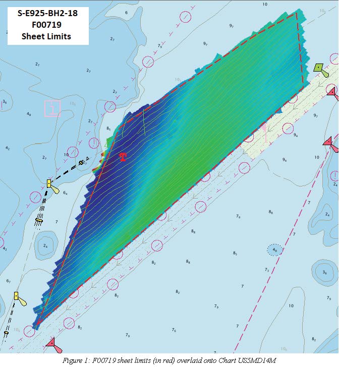
F00719: NOS Hydrographic Survey , 2018-05-22 recent views
National Oceanic and Atmospheric Administration, Department of Commerce —
The National Oceanic and Atmospheric Administration (NOAA) has the statutory mandate to collect hydrographic data in support of nautical chart compilation for safe... -
Federal
US EPA Nonattainment Areas and Designations-8 Hour Ozone (2008 NAAQS) recent views
U.S. Environmental Protection Agency —
This web service contains the following layers: Ozone 2008 NAAQS NAA State Level and Ozone 2008 NAAQS NAA National Level. Full FGDC metadata records for each layer... -
Federal
2004 Sediment Profile Imaging (SPI) Data for Catlett and Goodwin Islands on the York River, Chesapeake Bay, Virginia (Ches_2004SPI) recent views
National Oceanic and Atmospheric Administration, Department of Commerce —
This data set represents the sediment profile imaging data from 2004 (79 stations).In Fall/Winter 2002, researchers from the Virginia Institute of Marine Science...

Official websites use .gov
A
.gov website belongs to an official government
organization in the United States.
Secure .gov websites use HTTPS
A
lock (
) or https:// means you’ve safely connected to
the .gov website. Share sensitive information only on official,
secure websites.