
-
Federal
Maritime Limits and Boundaries of United States of America NGDA recent views
National Oceanic and Atmospheric Administration, Department of Commerce —
NOAA is responsible for depicting on its nautical charts the limits of the 12 nautical mile Territorial Sea, 24 nautical mile Contiguous Zone, and 200 nautical mile... -
Federal
Sea Level Trends: Sea Level Variations of the United States Derived from National Water Level Observation Network Stations NGDA recent views
National Oceanic and Atmospheric Administration, Department of Commerce —
Water level records are a combination of the fluctuations of the ocean and the vertical land motion at the location of the station. Monthly mean sea level (MSL)... -
Federal
Tides and Currents Map: an interactive map of all CO-OPS stations NGDA recent views
National Oceanic and Atmospheric Administration, Department of Commerce —
This interactive map has many features designed to provide a quick and easy way to find a Center for Operational Oceanographic Products and Services (CO-OPS) station.... -
Federal
Continental United States Hurricane Strikes Since 1950 recent views
National Oceanic and Atmospheric Administration, Department of Commerce —
This is an annual edition poster showing all of the hurricanes having impacted the continental U.S. from 1950 to 2022. This 36x28 inch glossy poster gives a quick... -
Federal
Social Vulnerability Index (SoVI) for the U.S. Coastal States based on the 2010 Census Tracts recent views
National Oceanic and Atmospheric Administration, Department of Commerce —
The Social Vulnerability Index (SoVI) 2006-10 measures the social vulnerability of U.S. counties to environmental hazards. The index is a comparative metric that... -
Federal
National Status and Trends: Mussel Watch Program recent views
National Oceanic and Atmospheric Administration, Department of Commerce —
Mussel Watch is the longest running continuous chemical contaminant monitoring program in U.S. coastal and Great Lakes waters and was created in response to concerns... -
Federal
Meteorological Data (including visibility) recent views
National Oceanic and Atmospheric Administration, Department of Commerce —
The National Ocean Service (NOS) maintains a long-term database containing data from active and historic stations installed all over the United States and U.S.... -
Federal
Shoreline Mapping Program of Back Bays, Delaware River, Arnold Point to Dyer Cove, NJ, NJ1404E-TB-C NGDA recent views
National Oceanic and Atmospheric Administration, Department of Commerce —
These data provide an accurate high-resolution shoreline compiled from imagery of Back Bays, Delaware River, Arnold Point to Dyer Cove, NJ . This vector shoreline... -
Federal
NOAA Composite Shoreline - Vectorized Shoreline Derived From NOAA-NOS Coastal Survey Maps and Aerial Photographs recent views
National Oceanic and Atmospheric Administration, Department of Commerce —
The NOAA Composite Shoreline is primarily intended for high-resolution cartographic representation of the shoreline. It is a high-resolution vector shoreline based on... -
Federal
NOAA Fisheries Community Social Vulnerability Indicators (CSVIs) recent views
National Oceanic and Atmospheric Administration, Department of Commerce —
The NOAA Fisheries Community Social Vulnerability Indicators (CSVIs) data series from 2009 to 2020 is comprised of a suite of indicators that describe and evaluate a... -
Federal
ESI GIS Data and PDF Maps: Environmental Sensitivity Index including GIS Data and Maps (for the U.S. Shorelines, including Alaska, Hawaii, and Puerto Rico) recent views
National Oceanic and Atmospheric Administration, Department of Commerce —
Environmental Sensitivity Index (ESI) maps are an integral component in oil-spill contingency planning and assessment. They serve as a source of information in the... -
Federal
test postSandy recent views
National Oceanic and Atmospheric Administration, Department of Commerce —
These data were collected by the National Oceanic Atmospheric Administration National Geodetic Survey Remote Sensing Division using a Riegl VQ820G system. The data... -
Federal
Coastal Change Analysis Program (C-CAP) Regional Land Cover Data and Change Data NGDA recent views
National Oceanic and Atmospheric Administration, Department of Commerce —
The NOAA Coastal Change Analysis Program (C-CAP) produces national standardized land cover and change products for the coastal regions of the U.S. C-CAP products... -
Federal
Historical Lighthouses recent views
National Oceanic and Atmospheric Administration, Department of Commerce —
This dataset includes lighthouses in coastal areas of the United States (including Puerto Rico) that may or may not be official or active aids for navigation. This... -
Federal
NOAA Shoreline Website recent views
National Oceanic and Atmospheric Administration, Department of Commerce —
The original intent of this site was to alleviate confusion about shorelines generated by National Oceanic and Atmospheric Administration (NOAA) agencies. However,... -
Federal
H10750: NOS Hydrographic Survey , Approaches to New York Harbor, New York, 1997-06-17 recent views
National Oceanic and Atmospheric Administration, Department of Commerce —
The National Oceanic and Atmospheric Administration (NOAA) has the statutory mandate to collect hydrographic data in support of nautical chart compilation for safe... -
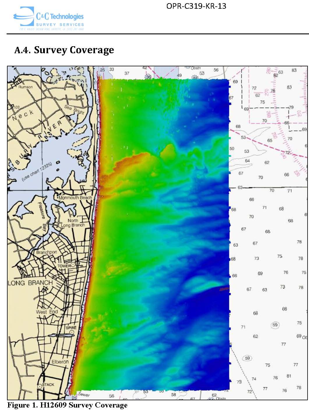
Federal
H12609: NOS Hydrographic Survey , 2015-02-07 recent views
National Oceanic and Atmospheric Administration, Department of Commerce —
The National Oceanic and Atmospheric Administration (NOAA) has the statutory mandate to collect hydrographic data in support of nautical chart compilation for safe... -
Federal
H10291: NOS Hydrographic Survey , Offshore New Jersey Coast, 1988-11-22 recent views
National Oceanic and Atmospheric Administration, Department of Commerce —
The National Oceanic and Atmospheric Administration (NOAA) has the statutory mandate to collect hydrographic data in support of nautical chart compilation for safe... -
Federal
H13474: NOS Hydrographic Survey , 2021-10-07 recent views
National Oceanic and Atmospheric Administration, Department of Commerce —
The National Oceanic and Atmospheric Administration (NOAA) has the statutory mandate to collect hydrographic data in support of nautical chart compilation for safe... -
Federal
2022 Cartographic Boundary File (SHP), Current Unified School District for New Jersey, 1:500,000 recent views
U.S. Census Bureau, Department of Commerce —
The 2022 cartographic boundary shapefiles are simplified representations of selected geographic areas from the U.S. Census Bureau's Master Address File /...

Official websites use .gov
A
.gov website belongs to an official government
organization in the United States.
Secure .gov websites use HTTPS
A
lock (
) or https:// means you’ve safely connected to
the .gov website. Share sensitive information only on official,
secure websites.
.jpg)
.jpg)