
-
Federal
Maritime Limits and Boundaries of United States of America NGDA recent views
National Oceanic and Atmospheric Administration, Department of Commerce —
NOAA is responsible for depicting on its nautical charts the limits of the 12 nautical mile Territorial Sea, 24 nautical mile Contiguous Zone, and 200 nautical mile... -
Federal
Sea Level Trends: Sea Level Variations of the United States Derived from National Water Level Observation Network Stations NGDA recent views
National Oceanic and Atmospheric Administration, Department of Commerce —
Water level records are a combination of the fluctuations of the ocean and the vertical land motion at the location of the station. Monthly mean sea level (MSL)... -
Federal
Meteorological Data (including visibility) recent views
National Oceanic and Atmospheric Administration, Department of Commerce —
The National Ocean Service (NOS) maintains a long-term database containing data from active and historic stations installed all over the United States and U.S.... -
Federal
Shoreline Data Rescue Project of Pamlico Sound, NC, NC1937B NGDA recent views
National Oceanic and Atmospheric Administration, Department of Commerce —
These data were automated to provide an accurate high-resolution historical shoreline of Pamlico Sound, NC suitable as a geographic information system (GIS) data... -
Federal
NOAA Composite Shoreline - Vectorized Shoreline Derived From NOAA-NOS Coastal Survey Maps and Aerial Photographs recent views
National Oceanic and Atmospheric Administration, Department of Commerce —
The NOAA Composite Shoreline is primarily intended for high-resolution cartographic representation of the shoreline. It is a high-resolution vector shoreline based on... -
Federal
Coastal Change Analysis Program (C-CAP) Regional Land Cover Data and Change Data NGDA recent views
National Oceanic and Atmospheric Administration, Department of Commerce —
The NOAA Coastal Change Analysis Program (C-CAP) produces national standardized land cover and change products for the coastal regions of the U.S. C-CAP products... -
Federal
H11722: NOS Hydrographic Survey , Approaches to Willmington, North Carolina, 2007-06-26 recent views
National Oceanic and Atmospheric Administration, Department of Commerce —
The National Oceanic and Atmospheric Administration (NOAA) has the statutory mandate to collect hydrographic data in support of nautical chart compilation for safe... -
Federal
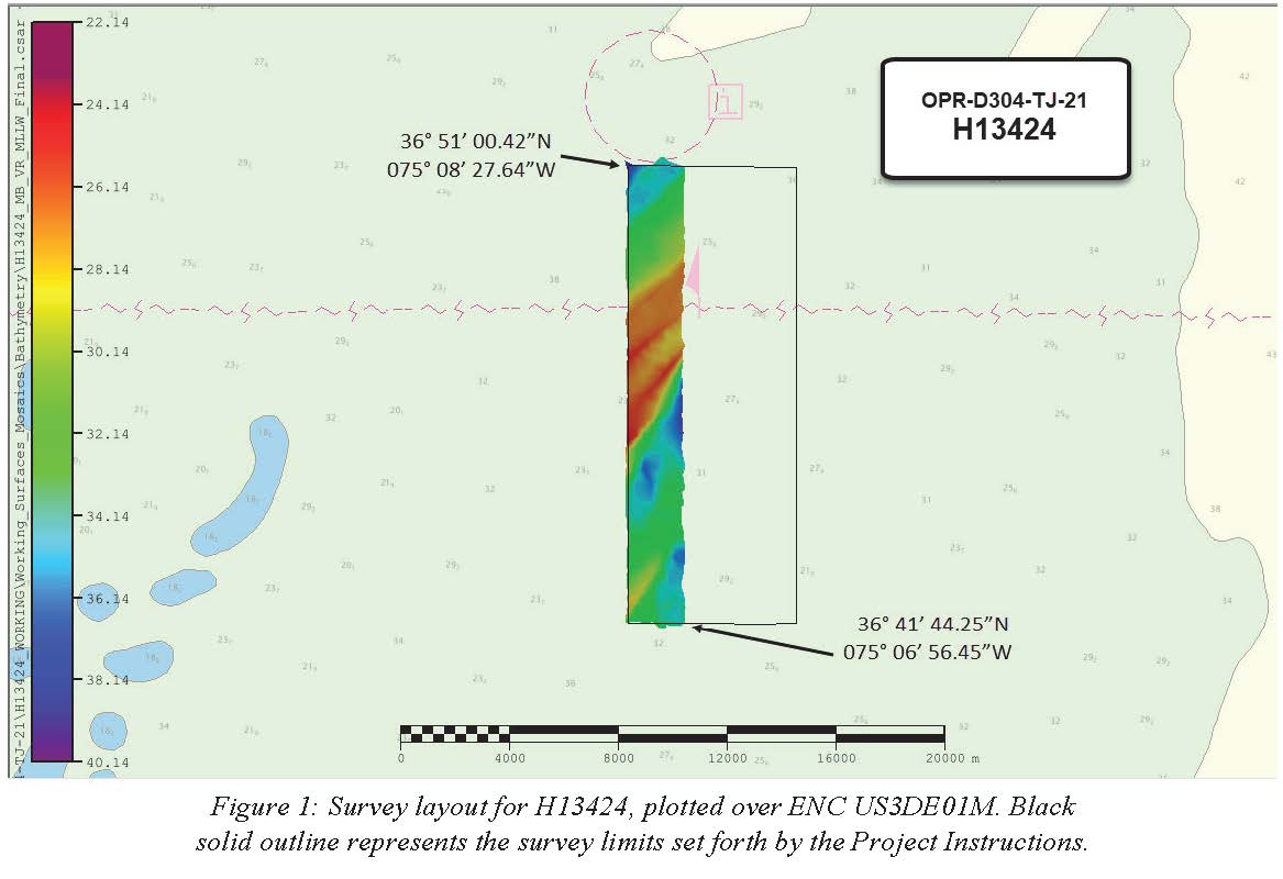
H13424: NOS Hydrographic Survey , 2021-07-18 recent views
National Oceanic and Atmospheric Administration, Department of Commerce —
The National Oceanic and Atmospheric Administration (NOAA) has the statutory mandate to collect hydrographic data in support of nautical chart compilation for safe... -
Federal
2014 NOAA NGS Ortho-rectified MLLW Infrared Mosaic of Cape Lookout, NC recent views
National Oceanic and Atmospheric Administration, Department of Commerce —
This data set contains ortho-rectified mosaic tiles, created as a product from the NOAA Integrated Ocean and Coastal Mapping (IOCM) initiative. The source imagery was... -
Federal
Shoreline Data Rescue Project of Cape Lookout, NC, NC1943A NGDA recent views
National Oceanic and Atmospheric Administration, Department of Commerce —
These data were automated to provide an accurate high-resolution historical shoreline of Cape Lookout, NC suitable as a geographic information system (GIS) data... -
Federal
Shoreline Data Rescue Project of Croatan Sound, North Carolina, EC12B05 NGDA recent views
National Oceanic and Atmospheric Administration, Department of Commerce —
These data were automated to provide an accurate high-resolution historical shoreline of Croatan Sound, North Carolina suitable as a geographic information system... -
Federal
Shoreline Data Rescue Project of Upper Part of Bay River, North Carolina, EC12C14 NGDA recent views
National Oceanic and Atmospheric Administration, Department of Commerce —
These data were automated to provide an accurate high-resolution historical shoreline of Upper Part of Bay River, North Carolina suitable as a geographic information... -
Federal
Shoreline Data Rescue Project of Beaufort Harbor, NC, NC13A05 NGDA recent views
National Oceanic and Atmospheric Administration, Department of Commerce —
These data were automated to provide an accurate high-resolution historical shoreline of Beaufort Harbor, NC suitable as a geographic information system (GIS) data... -
Federal
Shoreline Data Rescue Project of North Carolina, IDX134L NGDA recent views
National Oceanic and Atmospheric Administration, Department of Commerce —
These data were automated to provide an accurate high-resolution historical shoreline of North Carolina suitable as a geographic information system (GIS) data layer.... -
Federal
Shoreline Data Rescue Project of Neuse River, NC, NC1935F1 NGDA recent views
National Oceanic and Atmospheric Administration, Department of Commerce —
These data were automated to provide an accurate high-resolution historical shoreline of Neuse River, NC suitable as a geographic information system (GIS) data layer.... -
Federal
2014 NOAA NGS Ortho-rectified Mean Low Low Water Color Mosaic of Cape Lookout, NC recent views
National Oceanic and Atmospheric Administration, Department of Commerce —
This data set contains ortho-rectified mosaic tiles, created as a product from the NOAA Integrated Ocean and Coastal Mapping (IOCM) initiative. The source imagery was... -
Federal
Shoreline Data Rescue Project of Coast of NC, Cape Fear River to Tubbs Inlet, NC, NC13A02B NGDA recent views
National Oceanic and Atmospheric Administration, Department of Commerce —
These data were automated to provide an accurate high-resolution historical shoreline of Coast of NC, Cape Fear River to Tubbs Inlet, NC suitable as a geographic... -
Federal
Shoreline Data Rescue Project of Blount Creek, NC, NC1935A2 NGDA recent views
National Oceanic and Atmospheric Administration, Department of Commerce —
These data were automated to provide an accurate high-resolution historical shoreline of Blount Creek, NC suitable as a geographic information system (GIS) data... -
Federal
H06542: NOS Hydrographic Survey , 1939-12-31 recent views
National Oceanic and Atmospheric Administration, Department of Commerce —
The National Oceanic and Atmospheric Administration (NOAA) has the statutory mandate to collect hydrographic data in support of nautical chart compilation for safe... -
Federal
H03047B: NOS Hydrographic Survey recent views
National Oceanic and Atmospheric Administration, Department of Commerce —
The National Oceanic and Atmospheric Administration (NOAA) has the statutory mandate to collect hydrographic data in support of nautical chart compilation for safe...

Official websites use .gov
A
.gov website belongs to an official government
organization in the United States.
Secure .gov websites use HTTPS
A
lock (
) or https:// means you’ve safely connected to
the .gov website. Share sensitive information only on official,
secure websites.
.jpg)