
-
City
HealthInsuranceCoverage 28 recent views
City of Ferndale, Michigan —
Health insurance coverage rates, from the American Community Survey, 2014 5-year Average, by Zip. For the Detroit Tri-County region. Data Driven Detroit calculated... -
County
Allegheny County Air Quality 27 recent views
Allegheny County / City of Pittsburgh / Western PA Regional Data Center —
Air quality data is collected from the Allegheny County Health Department monitors throughout the county. This data must be verified by qualified individuals before... -
Federal
VIIRS Plus DMSP Change in Lights (VIIRS+DMSP dLIGHT)
National Aeronautics and Space Administration —
The VIIRS Plus DMSP Change in Lights (VIIRS+DMSP dLIGHT) data set fuses nighttime lights imagery from the U.S. Air Force Defense Meteorological Satellite Program... -
Federal
BLM ID Range Improvement Point
Department of the Interior —
This geodatabase of point, line and polygon features is an effort to consolidate all of the range improvement locations on BLM-managed land in Idaho into one... -
University
Legislative Districts of Idaho for 1992 - 2002 [Historical]
University of Idaho —
The downloadable ZIP file contains Esri shapefiles and PDF maps. Contains the information used to determine the location of the new legislative and congressional... -
Federal
Foreign Affairs Manual (2 FAM) - 2 FAM 300 Protocol, Precedence, and Formalities, section 350 TRIBUTE OF APPRECIATION CERTIFICATE
Department of State —
The Foreign Service Act of 1980 mandated a comprehensive revision to the operation of the Department of State and the personnel assigned to the US Foreign Service. As... -
Federal
Liquid Robotics Wave Glider, Honey Badger (G3), 2015, MOSE, version 2
National Oceanic and Atmospheric Administration, Department of Commerce —
Liquid Robotics Wave Glider, Honey Badger (G3), 2015, MOSE (version 2, from Cara Wilson). The MAGI mission is to use the Wave Glider to sample the late summer... -
Federal
HARV replication of the BRIC-23 Bacillus subtilis spaceflight
National Aeronautics and Space Administration —
Previous spaceflight experiments using Bacillus subtilis have reported altered transcriptome profiles during spaceflight compared to matching ground samples. This... -
Federal
NOS CO-OPS Water Level Data, Preliminary, 1-Minute
National Oceanic and Atmospheric Administration, Department of Commerce —
This dataset has recent, preliminary (not quality-controlled), 1-minute, water level (tide) data from NOAA NOS Center for Operational Oceanographic Products and... -
Federal
Liquid Robotics Wave Glider, Honey Badger (G3), 2015, C3
National Oceanic and Atmospheric Administration, Department of Commerce —
Liquid Robotics Wave Glider, Honey Badger (G3), 2015, C3. C3 board number 8215 (not coated) appears as board_id=32, task_id=23. C3 board number 771 (coated) appears... -
Federal
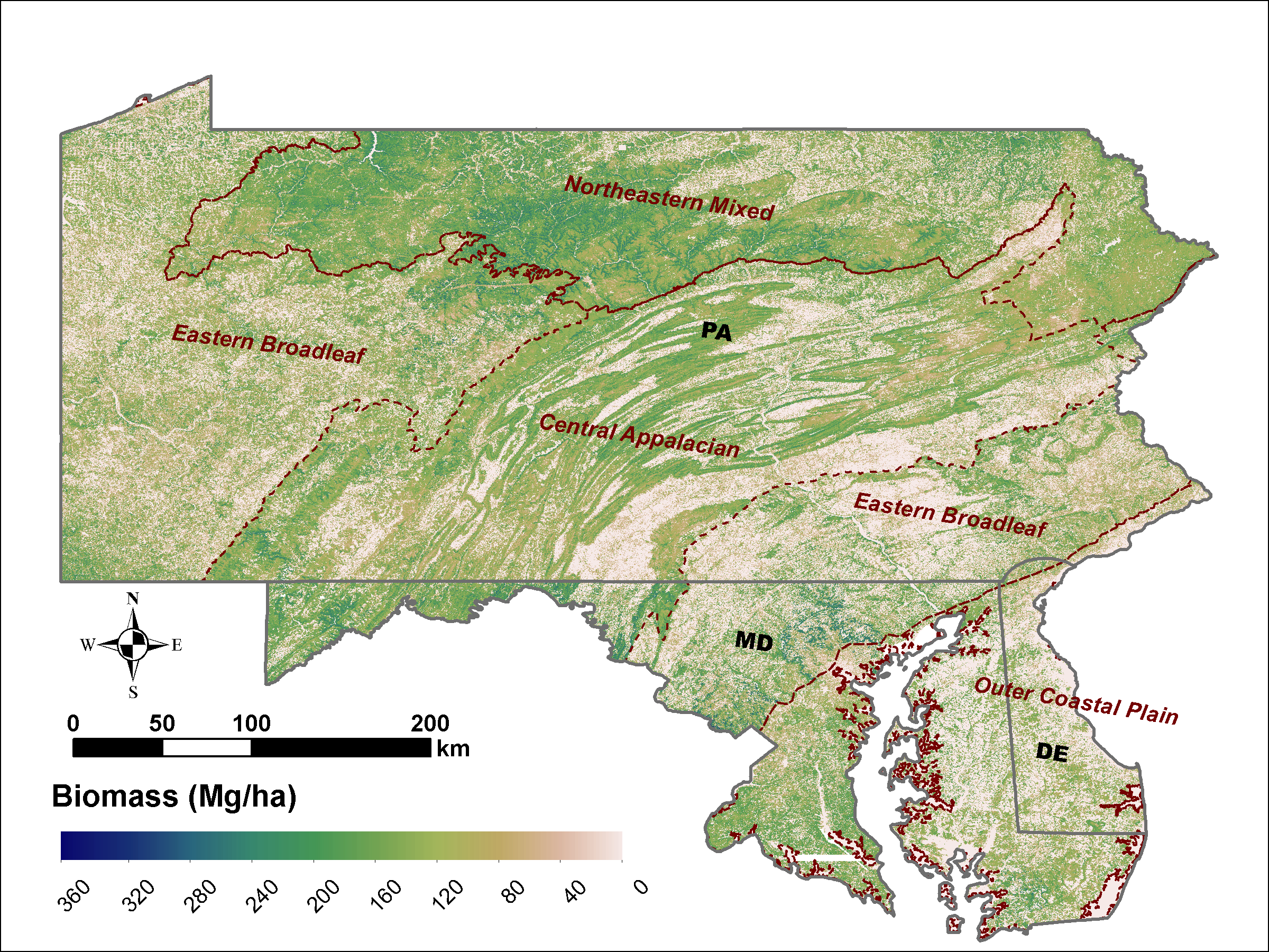
LiDAR Derived Biomass, Canopy Height and Cover for Tri-State (MD, PA, DE) Region, V2
National Aeronautics and Space Administration —
This dataset provides 30-meter gridded estimates of aboveground biomass (AGB), forest canopy height, and canopy coverage for Maryland, Pennsylvania, and Delaware in... -
County
Allegheny County Toxics Release Inventory
Allegheny County / City of Pittsburgh / Western PA Regional Data Center —
The Toxics Release Inventory (TRI) data provides information about toxic substances released into the environment or managed through recycling, energy recovery, and... -
Federal
NOS CO-OPS Water Level Data, Verified, Hourly
National Oceanic and Atmospheric Administration, Department of Commerce —
This dataset has verified (quality-controlled), hourly, water level (tide) data from NOAA NOS Center for Operational Oceanographic Products and Services (CO-OPS).... -
Federal
Research Report of Low Temperature Geothermal Play Fairway Analysis for the Appalachian Basin
Department of Energy —
This is a final report summarizing a one-year (2014-15) DOE funded Geothermal Play Fairway Analysis of the Low-Temperature resources of the Appalachian Basin of New... -
Federal
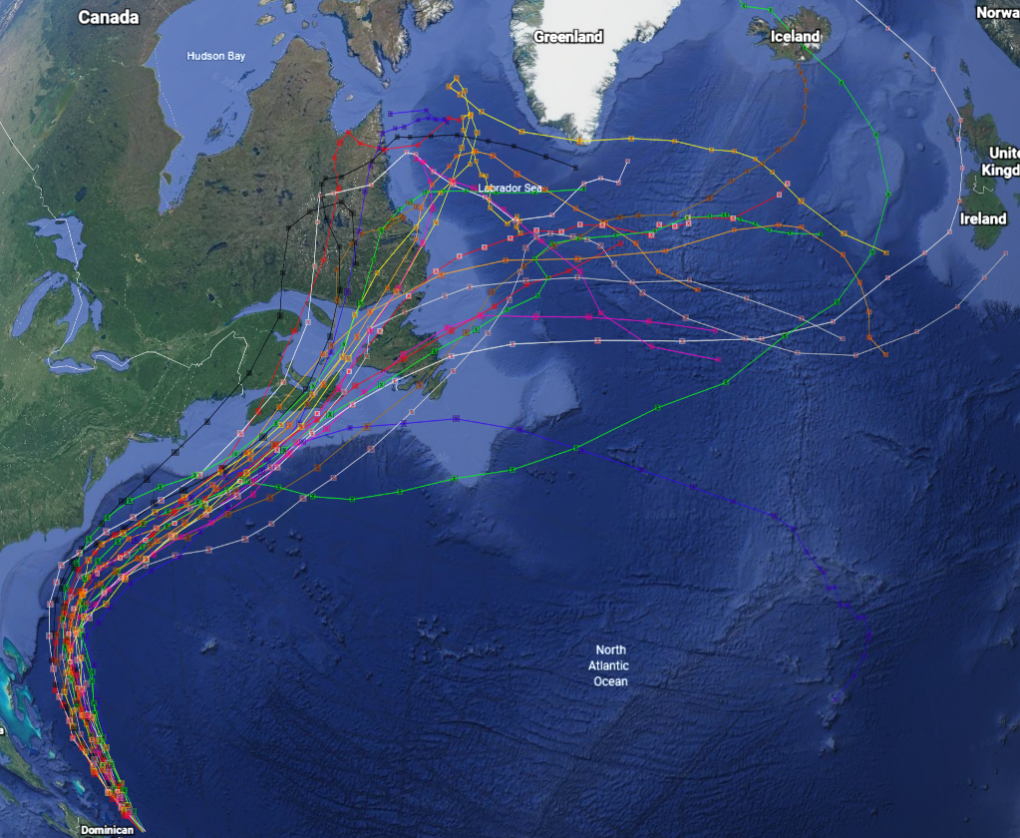
GRIP Hurricane and Tropical Storm Forecasts V1
National Aeronautics and Space Administration —
The GRIP Hurricane and Tropical Storm Forecasts dataset consists of tropical cyclone model forecast tracks archived during the NASA Genesis and Rapid Intensification... -
Federal
Grass-Cast Database - Data on aboveground net primary productivity (ANPP), climate data, NDVI, and cattle weight gain for Western U.S. rangelands
Department of Agriculture —
Grass-Cast: Experimental Grassland Productivity Forecast for the Great Plains Grass-Cast uses almost 40 years of historical data on weather and vegetation growth in... -
Federal
Global Human Built-up And Settlement Extent (HBASE) Dataset From Landsat
National Aeronautics and Space Administration —
The Global Human Built-up And Settlement Extent (HBASE) Dataset from Landsat is a global map of HBASE derived from the Global Land Survey (GLS) Landsat dataset for... -
Federal
Global Man-made Impervious Surface (GMIS) Dataset From Landsat
National Aeronautics and Space Administration —
The Global Man-made Impervious Surface (GMIS) Dataset From Landsat consists of global estimates of fractional impervious cover derived from the Global Land Survey... -
City
SMART Bus Route 2017
City of Ferndale, Michigan —
Most current available data on Suburban Mobility Authority for Regional Transportation (SMART) bus routes in the Tri-County area of Southeast Michigan.Click here for... -
City
Louisville Metro KY - CSV Containing Summary Data of LouVelo Station Usage for Drop Offs/Trip Ends
Louisville Metro Government —
LouVelo is a docked bikeshare program owned by Louisville Metro Government and operated by Cyclehop since May of 2017. The System includes Approximately 250 bikes,...

Official websites use .gov
A
.gov website belongs to an official government
organization in the United States.
Secure .gov websites use HTTPS
A
lock (
) or https:// means you’ve safely connected to
the .gov website. Share sensitive information only on official,
secure websites.