
-
Federal
CYGNSS Level 3 Ocean Microplastic Concentration Version 3.2
National Aeronautics and Space Administration —
The CYGNSS L3 Ocean Microplastic Concentration V3.2 dataset is provided by the CYGNSS Science Team of the University of Michigan.CYGNSS was launched on 15 December... -
Federal
CYGNSS L3 Ocean Microplastic Concentration V1.0
National Aeronautics and Space Administration —
This dataset contains the version 1.0 CYGNSS level 3 ocean microplastic concentration data record, which provides 18 netCDF files, each containing one month of daily... -
Federal
A National Thermal Generator Performance Database
Department of Energy —
This submission contains cleaned and filtered data from the Environmental Protection Agency Clean Air Markets CAM database of thermal power plant operation and... -
Federal
Life Cycle Emissions Factors for Electricity Generation Technologies
Department of Energy —
This dataset consists of a table containing the distribution of literature estimates of greenhouse gas emissions for the following electricity generation and storage... -
Federal
SHIFT: Wetland Spectra, Salinity, and Fractional Cover, Devereux Slough, CA, 2022
National Aeronautics and Space Administration —
This dataset includes field data, analysis code, and corresponding airborne imagery collected and generated during the 2022 NASA Surface Biology Geology (SBG) High... -
Federal
CMS (Carbon Monitoring System) Methane (CH4) Flux for North America 0.5 degree x 0.667 degree V1 (CMS_CH4_FLX_NA) at GES DISC
National Aeronautics and Space Administration —
An error was found in this product; therefore, it has been deleted. Please use the CMS Methane (CH4) Flux for North America Daily product (CMS_CH4_FLX_NAD, DOI:... -
Federal
Longwave-infrared spectral imagery in support of COMEX, 2014
National Aeronautics and Space Administration —
This dataset provides calibrated at-sensor radiance, retrieved surface brightness temperature, and adaptive coherence estimator (ACE) detection imagery of methane,... -
Federal
SCOAPE-II R/V Point Sur Data
National Aeronautics and Space Administration —
SCOAPE2_RVPointSur_Data is the data collected from instruments onboard the University of Southern Mississippi’s Research Vessel (R/V) Point Sur during the Satellite... -
Federal
MODIS/Terra Thermal Anomalies/Fire Daily L3 Global 1km SIN Grid V006
National Aeronautics and Space Administration —
The MOD14A1 Version 6 data product was decommissioned on July 31, 2023. Users are encouraged to use the MOD14A1 Version 6.1 data product.The Terra Moderate Resolution... -
Federal
Characterization of zinc carboxylates in an oil paint test panel [dataset]
Department of Commerce —
This dataset contains X-ray EDS (energy dispersive spectroscopy), FTIR (Fourier transform infrared spectroscopy), and DART-MS (Direct analysis in real time mass... -
Federal
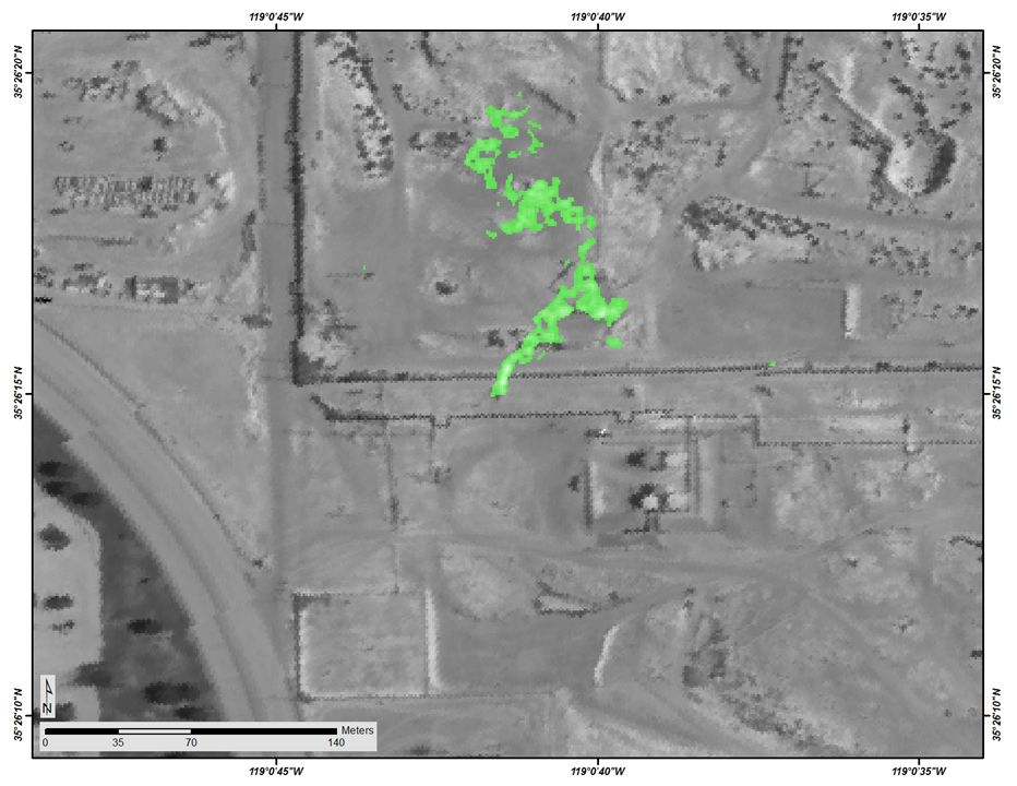
Sources of Methane Emissions (Vista-CA), State of California, USA
National Aeronautics and Space Administration —
This dataset provides spatial data products with identified and organized locations of potential methane (CH4) emitting facilities and infrastructure spanning the... -
Federal
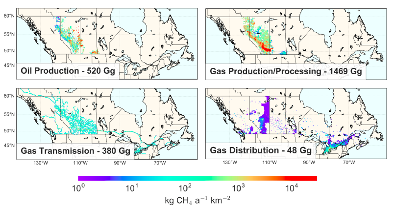
Methane (CH4) Flux for Canadian Oil/Gas Systems L4 V1 (CMS_CH4_FLX_CA) at GES DISC
National Aeronautics and Space Administration —
This data set (CMS_CH4_FLX_CA) contains the yearly average methane (CH4) flux for Canada's oil and gas systems based on a bottom up calculation of oil/gas emissions... -
Federal
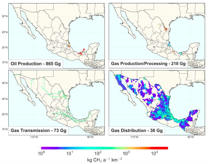
Methane (CH4) Flux for Mexican Oil/Gas Systems L4 V1 (CMS_CH4_FLX_MX) at GES DISC
National Aeronautics and Space Administration —
This data set (CMS_CH4_FLX_MX) contains the yearly average methane (CH4) flux for Mexico's oil and gas systems based on a bottom up calculation of oil/gas emissions... -
Federal
MASTER: BP Oil Spill Mapping, Louisiana-Gulf of America-Wisconsin, Fall, 2010
National Aeronautics and Space Administration —
This dataset includes Level 1B (L1B) and Level 2 (L2) data products from the MODIS/ASTER Airborne Simulator (MASTER) instrument. The raw data were collected during 9... -
Federal
Measurements during the Deepwater Horizon Oil Spill in the Gulf of Mexico (GOM)
National Aeronautics and Space Administration —
Measurements made in the Gulf of Mexico in 2010 during the Deepwater Horizon Oil Spill. -
Federal
Validating PACE aerosol columnar properties and OCI water-leaving radiances from ground-based network spectroradiometer measurements
National Aeronautics and Space Administration —
Multiple units of in-house built SMART-s (Spectral Measurements for Atmospheric Radiative Transfer-spectrometer, 330870 nm at ~0.8 nm resolution), as a part of... -
Federal
Sources of Methane Emissions (Vista-LA), South Coast Air Basin, California, USA
National Aeronautics and Space Administration —
This data set provides spatial data products with identified and classified locations of potential methane (CH4) emitting facilities and infrastructure in the South... -
Federal
Alpha Jet Atmopsheric eXperiment Meteorological Measurement System (MMS) Data
National Aeronautics and Space Administration —
The Alpha Jet Atmospheric eXperiment (AJAX) is a partnership between NASA's Ames Research Center and H211, L.L.C., facilitating routine in-situ measurements over... -
Federal
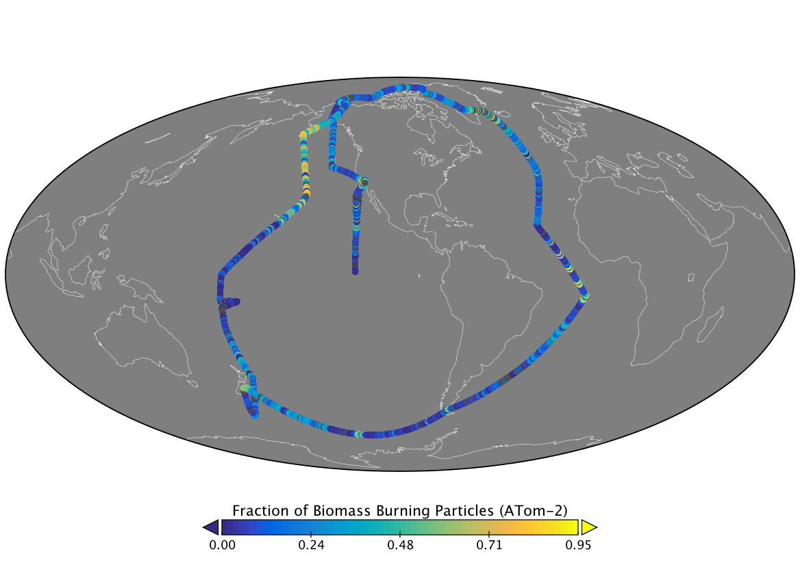
ATom: Measurements from Particle Analysis By Laser Mass Spectrometry (PALMS)
National Aeronautics and Space Administration —
This dataset contains single-particle aerosol composition as measured by the Particle Analysis by Laser Mass Spectrometry (PALMS) instrument during the four ATom... -
Federal
CAR Kuwait Oil Fire BRDF V2 (CAR_KUWAITOILFIRE_BRDF) at GES DISC
National Aeronautics and Space Administration —
CAR Kuwait Oil Fire mission measured bidirectional reflectance function of smoke from Kuwait oil fires during the Kuwait Oil Fire Smoke Experiment. Measurements were...

Official websites use .gov
A
.gov website belongs to an official government
organization in the United States.
Secure .gov websites use HTTPS
A
lock (
) or https:// means you’ve safely connected to
the .gov website. Share sensitive information only on official,
secure websites.