
-
Federal
Aboveground Biomass, Landcover, and Degradation, Kalimantan Forests, Indonesia, 2014
National Aeronautics and Space Administration —
This dataset provides estimates of aboveground biomass, percent canopy cover, mean canopy height, landcover, and forest degradation index products for forests in... -
Federal
ISLSCP II EDGAR 3 Gridded Greenhouse and Ozone Precursor Gas Emissions
National Aeronautics and Space Administration —
The EDGAR (Emission Database for Global Atmospheric Research) database project is a comprehensive task carried out jointly by the National Institute for Public Health... -
Federal
LBA-ECO LC-14 Modeled Deforestation Scenarios, Amazon Basin: 2002-2050
National Aeronautics and Space Administration —
This data set provides the results of the two modeled scenarios for future patterns of deforestation across the Amazon Basin from 2002 to 2050. This larger defined... -
Federal
ISLSCP II GlobalView: Atmospheric Methane Concentrations
National Aeronautics and Space Administration —
The GlobalView Methane (CH4) data product contains synchronized and smoothed time series of atmospheric CH4 concentrations at selected sites that were created using... -
Federal
ABoVE: Last Day of Spring Snow, Alaska, USA, and Yukon Territory, Canada, 2000-2016
National Aeronautics and Space Administration —
This dataset provides the last day of spring snow cover for most of Alaska and the Yukon Territory for 2000 through 2016. The data are based on the MODIS daily snow... -
Federal
VEMAP 1: U.S. Site Files
National Aeronautics and Space Administration —
The Vegetation/Ecosystem Modeling and Analysis Project (VEMAP) is an ongoing multiinstitutional, international effort addressing the response of biogeography and... -
Federal
Leaf Area Index Maps at 30-m Resolution, VALERI Site, Larose, Canada
National Aeronautics and Space Administration —
This data set provide local LAI maps for the Larose (Ontario) site in Canada. These derived maps may also be useful for validating other LAI maps over this same site... -
Federal
LBA-ECO LC-08 Soil, Vegetation, and Land Cover Maps for Brazil and South America
National Aeronautics and Space Administration —
This data set provides (1) soil maps for Brazil that are digital versions of the MAPA DE SOLOS DO BRASIL (EMBRAPA, 1981) classified at three levels of detail,... -
Federal
L2 Daily Solar-Induced Fluorescence (SIF) from ERS-2 GOME, 1995-2003
National Aeronautics and Space Administration —
This dataset provides Level 2 Solar-Induced Fluorescence (SIF) of Chlorophyll estimates derived from the Global Ozone Monitoring Experiment (GOME) instrument on the... -
Federal
LBA-ECO TG-07 Forest Soil P, C, and N Pools, km 83 Site, Tapajos National Forest
National Aeronautics and Space Administration —
This data set reports phosphorus (P), carbon (C), and nitrogen (N) nutrient pool concentrations for forest soils and roots and P pool concentrations for forest floor... -
Federal
CMS: Aboveground Biomass for Mangrove Forest, Zambezi River Delta, Mozambique
National Aeronautics and Space Administration —
This dataset provides several estimates of aboveground biomass from various regressions and allometries for mangrove forest in the Zambezi River Delta, Mozambique.... -
Federal
MASTER: Airborne Science, Nevada, May 2006
National Aeronautics and Space Administration —
This dataset includes Level 1B (L1B) data products from the MODIS/ASTER Airborne Simulator (MASTER) instrument. The spectral data were collected during five flights... -
Federal
BOREAS TE-23 Map Plot Data
National Aeronautics and Space Administration —
The BOREAS TE-23 team collected map plot data in support of its efforts to characterize and interpret information on canopy architecture and understory cover at the... -
Federal
LBA-ECO LC-02 GOES-08 Hot Pixel Data from Acre, Brazil: 1998, 2000, and 2001
National Aeronautics and Space Administration —
This data set provides hot pixel data, as an indicator of fires that were detected by the GOES-8 satellite for the state of Acre, Brazil. Image data were collected... -
Federal
BOREAS TE-09 Leaf Biochemistry Averages
National Aeronautics and Space Administration —
The BOREAS TE-09 team collected several data sets related to chemical and photosynthetic properties of leaves. This data set contains canopy biochemistry data... -
Federal
LBA Regional Mean Climatology, 0.5-Deg, 1930-1960, V. 2.1 (Cramer and Leemans)
National Aeronautics and Space Administration —
This data set is a subset of Cramer and Leemans' (2001) global database of mean monthly climatology, which contains monthly averages of mean temperature, temperature... -
Federal
BOREAS RSS-08 Snow Maps Derived from Landsat TM Imagery
National Aeronautics and Space Administration —
The BOREAS RSS-08 team utilized Landsat TM images to perform mapping of snow extent over the SSA. This data set consists of two Landsat TM images which were used to... -
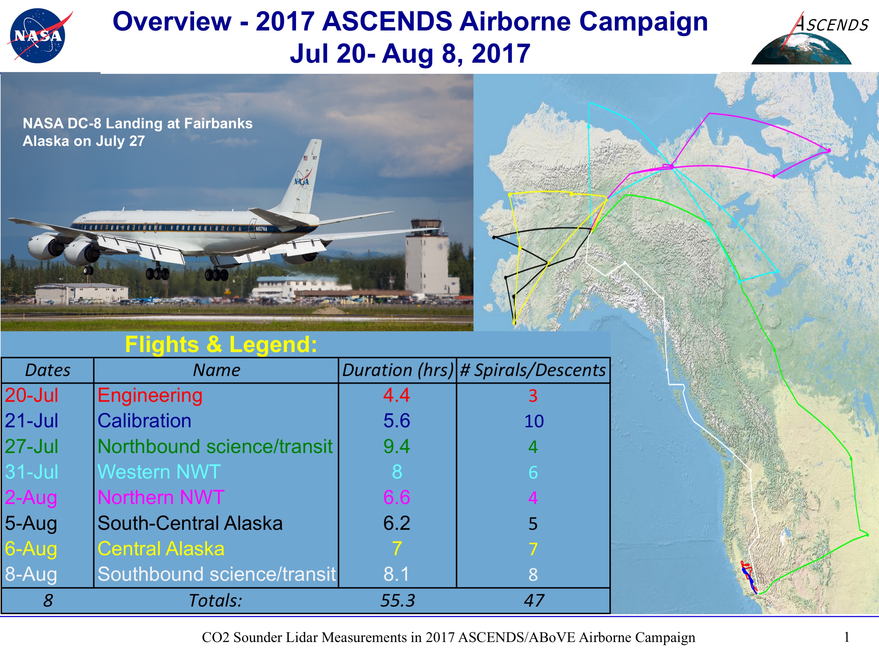
Federal
ABoVE/ASCENDS: Merged Atmospheric CO2, CH4, and Meteorological Data, 2017
National Aeronautics and Space Administration —
This dataset provides in situ airborne measurements of atmospheric carbon dioxide (CO2), methane (CH4), water vapor concentrations, air temperature, pressure, and... -
Federal
Amazon Forest Structure from Airborne Lidar, ED2 Initial Condition Files, 2016
National Aeronautics and Space Administration —
This dataset provides initial condition files for initializing the Ecosystem Demography Model (ED2). This dataset holds regional forest structure characteristics... -
Federal
BOREAS RSS-10 TOMS Circumpolar One-Degree PAR Images
National Aeronautics and Space Administration —
The BOREAS RSS-10 team investigated the magnitude of daily, seasonal, and yearly variations of PAR from ground and satellite observations. This data set contains...

Official websites use .gov
A
.gov website belongs to an official government
organization in the United States.
Secure .gov websites use HTTPS
A
lock (
) or https:// means you’ve safely connected to
the .gov website. Share sensitive information only on official,
secure websites.