
-
Federal
Global Distribution of Root Turnover in Terrestrial Ecosystems
National Aeronautics and Space Administration —
Estimates of root turnover rates were calculated from measurements of live root standing crop and belowground net primary production (BNPP) compiled from the primary... -
Federal
BOREAS RSS-10 TOMS Circumpolar One-Degree PAR Images
National Aeronautics and Space Administration —
The BOREAS RSS-10 team investigated the magnitude of daily, seasonal, and yearly variations of PAR from ground and satellite observations. This data set contains... -
Federal
NACP Aboveground Biomass and Carbon Baseline Data, V.2 (NBCD 2000), U.S.A., 2000
National Aeronautics and Space Administration —
The NBCD 2000 (National Biomass and Carbon Dataset for the Year 2000) data set provides a high-resolution (30 m) map of year-2000 baseline estimates of basal area-... -
Federal
ABoVE: Permafrost Measurements and Distribution Across the Y-K Delta, Alaska, 2016
National Aeronautics and Space Administration —
This dataset provides field observations of thaw depth and dominant vegetation types, a LiDAR-derived elevation map, and permafrost distribution and probability maps... -
Federal
NACP Regional: National Greenhouse Gas Inventories and Aggregated Gridded Model Data
National Aeronautics and Space Administration —
This data set provides two products that were derived from the recently published North American Carbon Program (NACP) Regional Synthesis 1-degree terrestrial... -
Federal
Aboveground Biomass Density for High Latitude Forests from ICESat-2, 2020
National Aeronautics and Space Administration —
This dataset provides estimates of Aboveground dry woody Biomass Density (AGBD) for high northern latitude forests at a 30-m spatial resolution. It is designed both... -
Federal
AirMOSS: L2 Hourly In-Ground Soil Moisture at AirMOSS Sites, 2011-2015
National Aeronautics and Space Administration —
This data set provides level 2 (L2) hourly volumetric (cm3/cm3) soil moisture profiles from in-ground sensors at seven North American sites as part of the Airborne... -
Federal
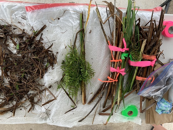
Delta-X: Aboveground Vegetation Structure, Herbaceous Wetlands, MRD, LA, USA, V2
National Aeronautics and Space Administration —
This dataset provides mean stem diameter, mean height, dominant species, hydrogeomorphic zone (HGM), and stem density for vegetation in herbaceous wetlands collected... -
Federal
ABoVE: Methane Flux across Two Thermokarst Lake Ecosystems, Interior Alaska, 2018
National Aeronautics and Space Administration —
This dataset provides diffusive methane (CH4) fluxes collected from two thermokarst lakes in the Goldstream Valley, north of Fairbanks in interior Alaska. Fluxes were... -
Federal
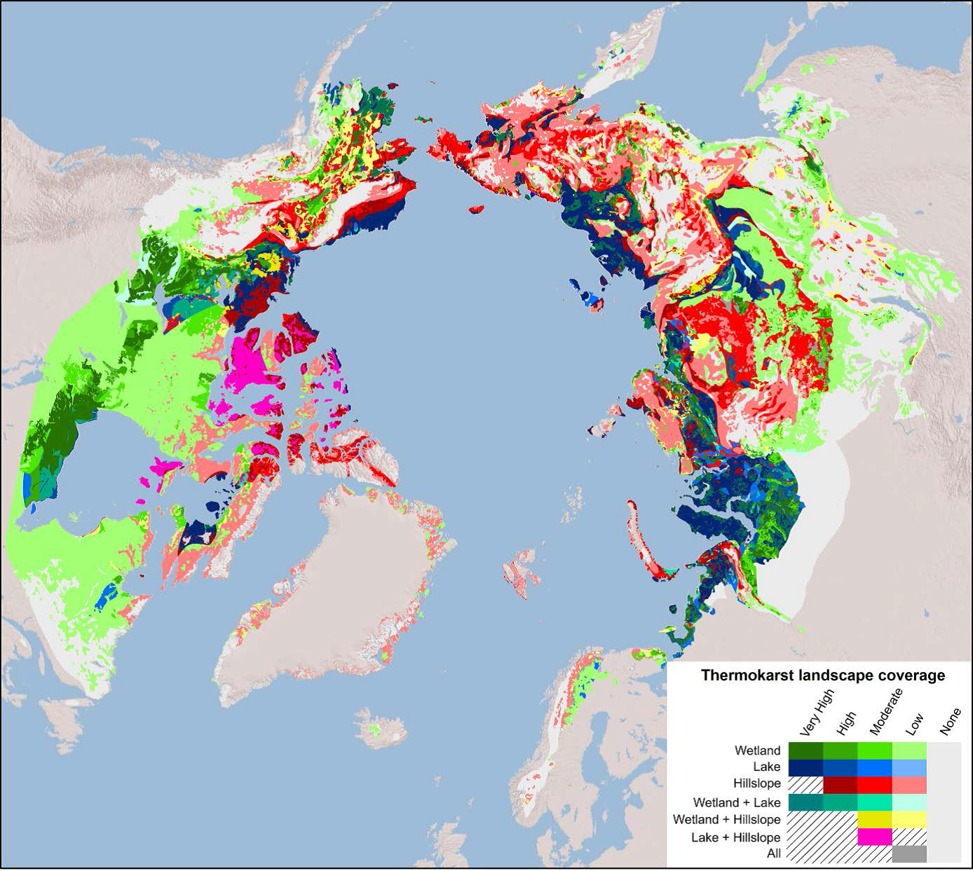
Arctic Circumpolar Distribution and Soil Carbon of Thermokarst Landscapes, 2015
National Aeronautics and Space Administration —
This data set provides the distribution of thermokarst landscapes in the boreal and tundra ecoregions within the northern circumpolar permafrost zones. This dataset... -
Federal
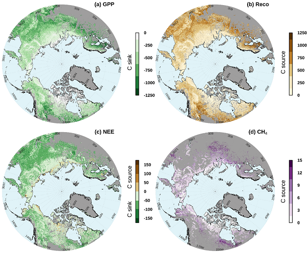
Gridded CO2 and CH4 Flux Estimates for pan-Arctic and Boreal Regions, 2003-2015
National Aeronautics and Space Administration —
This dataset provides gridded estimates of gross primary productivity (GPP), ecosystem respiration (Reco), net ecosystem CO2 exchange (NEE = Reco - GPP), and methane... -
Federal
AirMOSS: L4 Modeled Volumetric Root Zone Soil Moisture, 2012-2015
National Aeronautics and Space Administration —
This data set provides hourly gridded soil moisture estimates derived from hydrologic modeling at nine AirMOSS sites across North America. The AirMOSS L4 RZSM product... -
Federal
Tidal Wetlands Soil Organic Carbon and Estuarine Characteristics, USA, 1972-2015
National Aeronautics and Space Administration —
This dataset provides a synthesis of soil organic carbon (SOC) estimates and a variety of other environmental information from tidal wetlands within estuaries in the... -
Federal
AirMOSS: L1 S-0 Polarimetric Data from AirMOSS P-band SAR, Harvard Forest, 2012-2015
National Aeronautics and Space Administration —
This data set provides level 1 (L1) polarimetric radar backscattering coefficient (sigma-0), multilook complex, polarimetrically calibrated, and georeferenced data... -
Federal
Tree Canopy Cover for the Circumpolar Taiga-Tundra Ecotone: 2000-2005
National Aeronautics and Space Administration —
This data set provides a map of selected areas with defined tree canopy cover over the circumpolar taiga-tundra ecotone (TTE). Canopy cover was derived from the... -
Federal
Coastal Wetland Elevation and Carbon Flux Inventory with Uncertainty, USA, 2006-2011
National Aeronautics and Space Administration —
This dataset provides maps of coastal wetland carbon and methane fluxes and coastal wetland surface elevation from 2006 to 2011 at 30 m resolution for coastal... -
Federal
AirMOSS: L1 S-0 Polarimetric Data from AirMOSS P-band SAR, La Selva, 2012-2015
National Aeronautics and Space Administration —
This data set provides level 1 (L1) polarimetric radar backscattering coefficient (sigma-0), multilook complex, polarimetrically calibrated, and georeferenced data... -
Federal
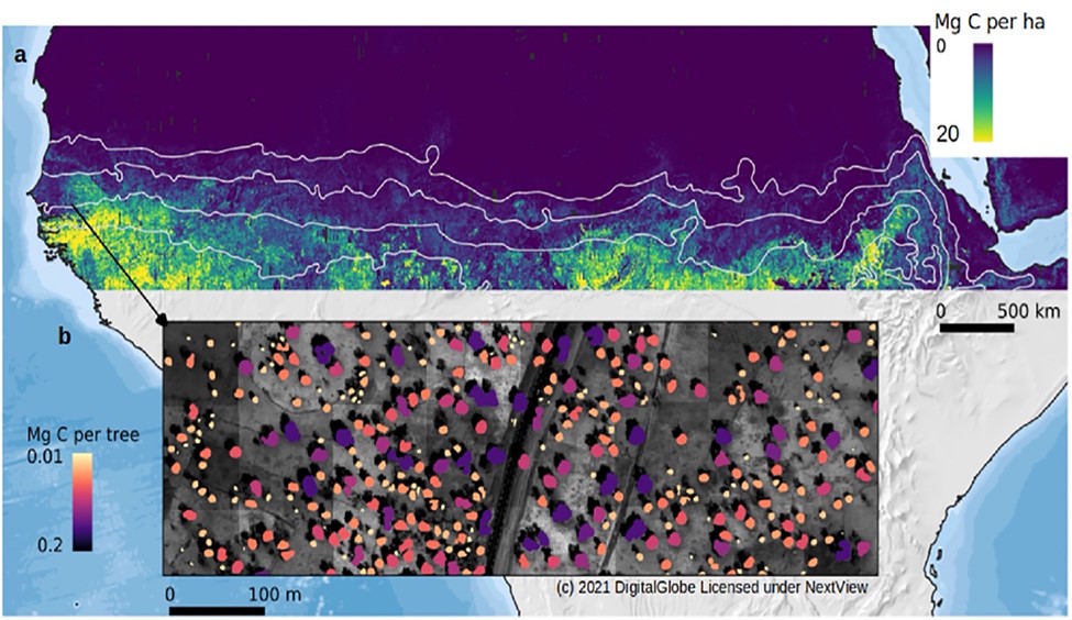
Carbon Stocks of Individual Trees in African Drylands: Allometry and Output Data
National Aeronautics and Space Administration —
This dataset provides allometrically-estimated carbon stocks of 9,947,310,221 tree crowns derived from 50-cm resolution satellite images within the 0 to 1000 mm/year...

Official websites use .gov
A
.gov website belongs to an official government
organization in the United States.
Secure .gov websites use HTTPS
A
lock (
) or https:// means you’ve safely connected to
the .gov website. Share sensitive information only on official,
secure websites.