
-
Federal
BOREAS RSS-10 TOMS Circumpolar One-Degree PAR Images
National Aeronautics and Space Administration —
The BOREAS RSS-10 team investigated the magnitude of daily, seasonal, and yearly variations of PAR from ground and satellite observations. This data set contains... -
Federal
LiDAR Derived Biomass, Canopy Height, and Cover for New England Region, USA, 2015
National Aeronautics and Space Administration —
This dataset provides 30 m gridded estimates of aboveground biomass density (AGBD), forest canopy height, and tree canopy coverage for the New England Region of the... -
Federal
Global Gridded Surfaces of Selected Soil Characteristics (IGBP-DIS)
National Aeronautics and Space Administration —
The Global Gridded Surfaces of Selected Soil Characteristics (IGBP-DIS) data set contains 7 data surfaces: soil-carbon density, total nitrogen density, field... -
Federal
Soil Organic Carbon Stock Estimates with Uncertainty across Latin America
National Aeronautics and Space Administration —
This dataset provides 5 x 5 km gridded estimates of soil organic carbon (SOC) across Latin America that were derived from existing point soil characterization data... -
Federal
LBA-ECO CD-03 Cloud Base-Backscatter Data, km 67 Tower Site, Tapajos National Forest
National Aeronautics and Space Administration —
A Vaisala CT-25K ceilometer was installed at an old-growth forest site located at the km 67 Eddy Flux Tower site in the Tapajos National Forest, Para, Brazil, off... -
Federal
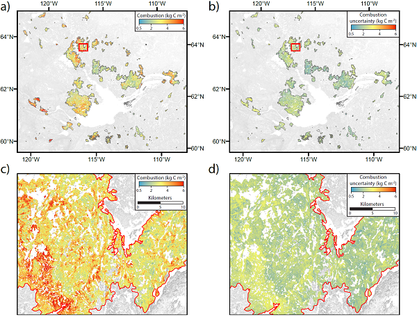
ABoVE: Wildfire Carbon Emissions and Burned Plot Characteristics, NWT, CA, 2014-2016
National Aeronautics and Space Administration —
This dataset provides estimates of wildfire carbon emissions and uncertainties at 30-m resolution, and measurements collected at burned and unburned field plots from... -
Federal
BOREAS AFM-02 Wyoming King Air 1994 Aircraft Sounding Data
National Aeronautics and Space Administration —
The BOREAS AFM-02 team used the University of Wyoming King Air aircraft during IFCs 1, 2, and 3 in 1994 to collected pass-by-pass fluxes (and many other statistics)... -
Federal
LBA-ECO ND-07 Nitric Oxide Flux from Cerrado Soils, Brasilia, Brazil: 2004
National Aeronautics and Space Administration —
This data set reports the results of soil nitric oxide (NO) flux, soil moisture, and soil nitrate (NO3) and ammonium (NH4) concentration measurements on Cerrado soils... -
Federal
NPP Multi-Biome: Summary Data from Intensive Studies at 125 Sites, 1936-2006
National Aeronautics and Space Administration —
This data set, NPP Multi-Biome: Summary Data from Intensive Studies at 125 Sites, 1936-2006, contains a single shapefile that provides site-level summary statistics... -
Federal
Aircraft Flux-Filtered: U of Wy. (FIFE)
National Aeronautics and Space Administration —
The University of Wyoming (UW) King Air atmospheric boundary layer measurement missions were flown in 1987 during IFCs 3 and 4. This Boundary Layer Fluxes data set... -
Federal
Spatio-temporal Characteristics of Rainfall in Africa, 0.25 degrees, from 1998-2012
National Aeronautics and Space Administration —
This data set describes rainfall distribution statistics over the African continent, including Madagascar. The rainfall estimates are based on data from the NASA... -
Federal
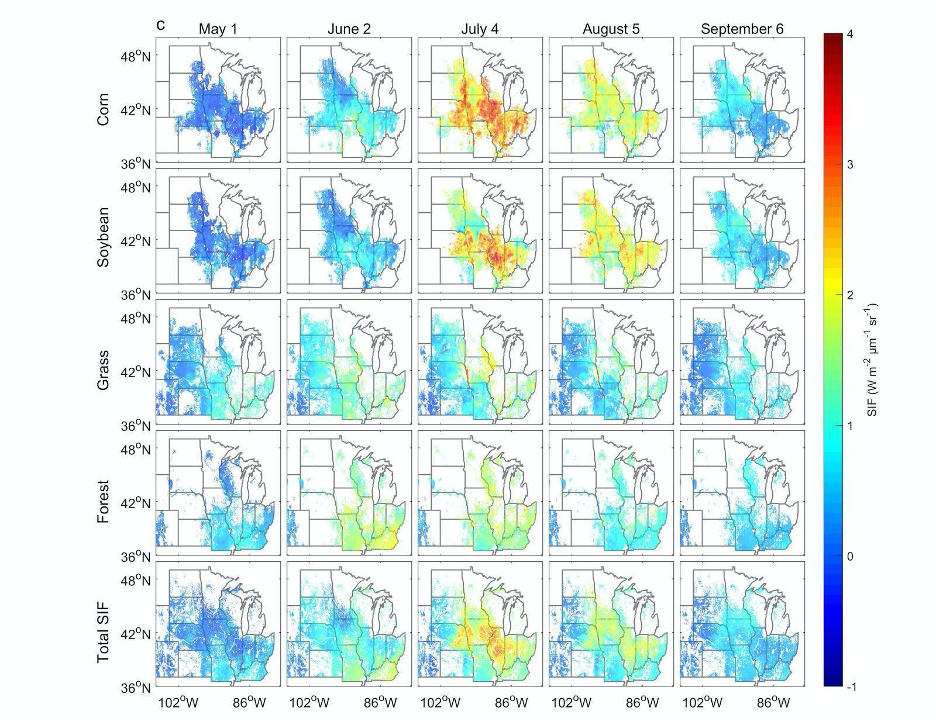
High Resolution Land Cover-Specific Solar-Induced Fluorescence, Midwestern USA, 2018
National Aeronautics and Space Administration —
This dataset provides estimated solar-induced chlorophyll fluorescence (SIF) of specific vegetation types and total SIF under clear-sky and real/cloudy conditions at... -
Federal
LBA-ECO LC-15 JERS-1 Synthetic Aperture Radar, 1- km Mosaic, Amazon Basin: 1995-1996
National Aeronautics and Space Administration —
This data set contains two image mosaics of L-band radar backscatter and two image mosaics of first order texture. The two backscatter images are mosaics of L-band... -
Federal
ABoVE: Ignitions, Burned Area, and Emissions of Fires in AK, YT, and NWT, 2001-2018
National Aeronautics and Space Administration —
This dataset provides estimates of daily burned area, carbon emissions, and uncertainty, and daily fire ignition locations for boreal fires in Alaska, U.S., and in... -
Federal
ISLSCP II HYDRO1k Elevation-derived Products
National Aeronautics and Space Administration —
This data set contains coarse scale elevation and elevation-based parameters at 1.0 and 0.5-degree spatial resolutions that were developed to support a wide variety... -
Federal
VEMAP 1: U.S. Soil
National Aeronautics and Space Administration —
The Vegetation/Ecosystem Modeling and Analysis Project (VEMAP) is an ongoing multiinstitutional, international effort addressing the response of biogeography and... -
Federal
SAFARI 2000 Global Burned Area Map, 1-km, Southern Africa, 2000
National Aeronautics and Space Administration —
The Global Burned Area 2000 initiative (GBA2000) was launched by the Global Vegetation Mapping Unit of the Joint Research Centre of the European Commission, in... -
Federal
SAFARI 2000 MAPSS MOD05_L2 Water Vapor Summary Data for Southern Africa
National Aeronautics and Space Administration —
The Moderate Resolution Imaging Spectroradiometer (MODIS) Atmosphere Group develops remote-sensing algorithms for deriving sets of atmospheric parameters from MODIS... -
Federal
Effects of Elevated Carbon Dioxide on Litter Chemistry and Decomposition
National Aeronautics and Space Administration —
The results of published and unpublished experiments investigating the impacts of elevated carbon dioxide on the chemistry (nitrogen and lignin concentration) of leaf...

Official websites use .gov
A
.gov website belongs to an official government
organization in the United States.
Secure .gov websites use HTTPS
A
lock (
) or https:// means you’ve safely connected to
the .gov website. Share sensitive information only on official,
secure websites.