
-
Federal
A Global Database of Gas Fluxes from Soils after Rewetting or Thawing, Version 1.0
National Aeronautics and Space Administration —
This database contains information compiled from published studies on gas flux from soil following rewetting or thawing. The resulting database includes 222 field and... -
Federal
A Global Database of Field-observed Leaf Area Index in Woody Plant Species, 1932-2011
National Aeronautics and Space Administration —
This data set provides global leaf area index (LAI) values for woody species. The data are a compilation of field-observed data from 1,216 locations obtained from 554... -
Federal
ISLSCP II GlobalView: Atmospheric Methane Concentrations
National Aeronautics and Space Administration —
The GlobalView Methane (CH4) data product contains synchronized and smoothed time series of atmospheric CH4 concentrations at selected sites that were created using... -
Federal
NACP Aboveground Biomass and Carbon Baseline Data, V.2 (NBCD 2000), U.S.A., 2000
National Aeronautics and Space Administration —
The NBCD 2000 (National Biomass and Carbon Dataset for the Year 2000) data set provides a high-resolution (30 m) map of year-2000 baseline estimates of basal area-... -
Federal
Annual Land Use and Urban Land Cover: Ethiopia, Nigeria, and South Africa, 2016-2020
National Aeronautics and Space Administration —
This dataset provides a two-tier annual Land Use (LU) and Urban Land Cover (LC) product suite over three African countries, Ethiopia, Nigeria, and South Africa,... -
Federal
LUH1: Harmonized Global Land Use for Years 1500-2100, V1
National Aeronautics and Space Administration —
These data represent fractional land use and land cover patterns annually for the years 1500 - 2100 for the globe at 0.5-degree (~50-km) spatial resolution. Land use... -
Federal
VEMAP 2: U.S. Annual Climate Change Scenarios
National Aeronautics and Space Administration —
The Vegetation/Ecosystem Modeling and Analysis Project (VEMAP) Phase 2 has developed a number of transient climate change scenarios based on coupled atmosphere-ocean... -
Federal
CARVE: L2 Atmospheric Gas Concentrations, Airborne Flasks, Alaska, 2012-2015
National Aeronautics and Space Administration —
This data set provides atmospheric carbon dioxide (CO2), methane (CH4), carbon monoxide (CO), molecular hydrogen (H2), nitrous oxide (N2O), sulfur hexafluoride (SF6),... -
Federal
Global Monthly Climatology for the Twentieth Century (New et al.)
National Aeronautics and Space Administration —
This is a data set of mean monthly surface climate data over global land areas, excluding Antarctica, for nearly all of the twentieth century. The data set is gridded... -
Federal
BigFoot Leaf Area Index Surfaces for North and South American Sites, 2000-2003
National Aeronautics and Space Administration —
The BigFoot project gathered leaf area index (LAI) data for nine EOS Land Validation Sites located from Alaska to Brazil from 2000 to 2003. Each site is... -
Federal
Arctic Vegetation Plots at Atqasuk, Alaska, 1975, 2000, and 2010
National Aeronautics and Space Administration —
This data set provides vegetation species abundance data collected in 1975 from 60 sites on the Arctic Coastal Plain near Atqasuk, Alaska, as well as environmental... -
Federal
BOREAS TE-18, 30-m, Radiometrically Rectified Landsat TM Imagery
National Aeronautics and Space Administration —
The BOREAS TE-18 team used a radiometric rectification process to produce standardized digital number (DN) values for a series of Landsat TM images of the BOREAS SSA... -
Federal
Vulcan: High-Resolution Hourly Fossil Fuel CO2 Emissions in USA, 2010-2015, Version 3
National Aeronautics and Space Administration —
The Vulcan version 3.0 hourly dataset quantifies hourly emissions at a 1-km resolution for the 2010-2015 time period. Estimates are provided of hourly carbon dioxide... -
Federal
LBA-ECO ND-06 Land Use Effects on Soil Nutrients: A Review of Studies 1950-2001
National Aeronautics and Space Administration —
This data set provides measurements of soil properties compiled from 39 studies on nutrient dynamics in natural forests and forest-derived land uses (pasture,... -
Federal
NACP MsTMIP Summary of Model Structure and Characteristics
National Aeronautics and Space Administration —
This data set provides a summary of the model structure and characteristics of participating models in the North American Carbon Program (NACP) Multi-scale synthesis... -
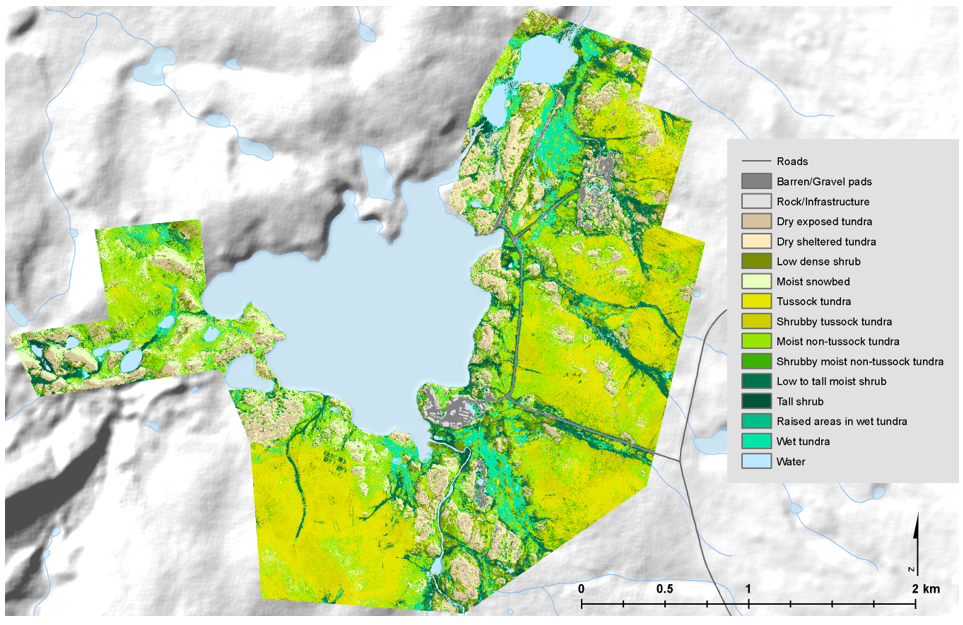
Federal
High-Resolution Vegetation Community Maps, Toolik Lake Area, Alaska, 2013-2015
National Aeronautics and Space Administration —
This dataset contains vegetation community maps at 20 cm resolution for three landscapes near the Toolik Lake research area in the northern foothills of the Brooks... -
Federal
NPP Multi-Biome: Summary Data from Intensive Studies at 125 Sites, 1936-2006
National Aeronautics and Space Administration —
This data set, NPP Multi-Biome: Summary Data from Intensive Studies at 125 Sites, 1936-2006, contains a single shapefile that provides site-level summary statistics... -
Federal
Delta-X: Aboveground Vegetation Structure, Herbaceous Wetlands, MRD, LA, USA, V2
National Aeronautics and Space Administration —
This dataset provides mean stem diameter, mean height, dominant species, hydrogeomorphic zone (HGM), and stem density for vegetation in herbaceous wetlands collected... -
Federal
Pantropical Forest Height and Biomass from GEDI and TanDEM-X Data Fusion
National Aeronautics and Space Administration —
This dataset includes maps of canopy height and aboveground biomass at spatial resolutions of 25 m and 100 m for Mexico, Gabon, French Guiana, and the Amazon Basin....

Official websites use .gov
A
.gov website belongs to an official government
organization in the United States.
Secure .gov websites use HTTPS
A
lock (
) or https:// means you’ve safely connected to
the .gov website. Share sensitive information only on official,
secure websites.