
-
Federal
Land Use and Cover Maps from Landsat, Mawas, Central Kalimantan, Indonesia, 1994-2019
National Aeronautics and Space Administration —
This dataset contains annual land use/cover (LUC) maps at 30 m resolution across Mawas, Central Kalimantan, Indonesia. There are six files, each representing a five-... -
Federal
BioSCape Vegetation Surveys Berg and Eerste River Catchments, South Africa, 2022-2023
National Aeronautics and Space Administration —
This dataset contains vegetation plot survey data collected at 36 sites across the Berg and Eerste River catchments in the Western Cape, South Africa collected during... -
Federal
ABoVE: Wetland Vegetation Classification for Peace-Athabasca Delta, Canada, 2019
National Aeronautics and Space Administration —
This dataset contains land cover classification focused on water and wetland vegetation communities over the Peace-Athabasca Delta, Canada. Four classification maps... -
Federal
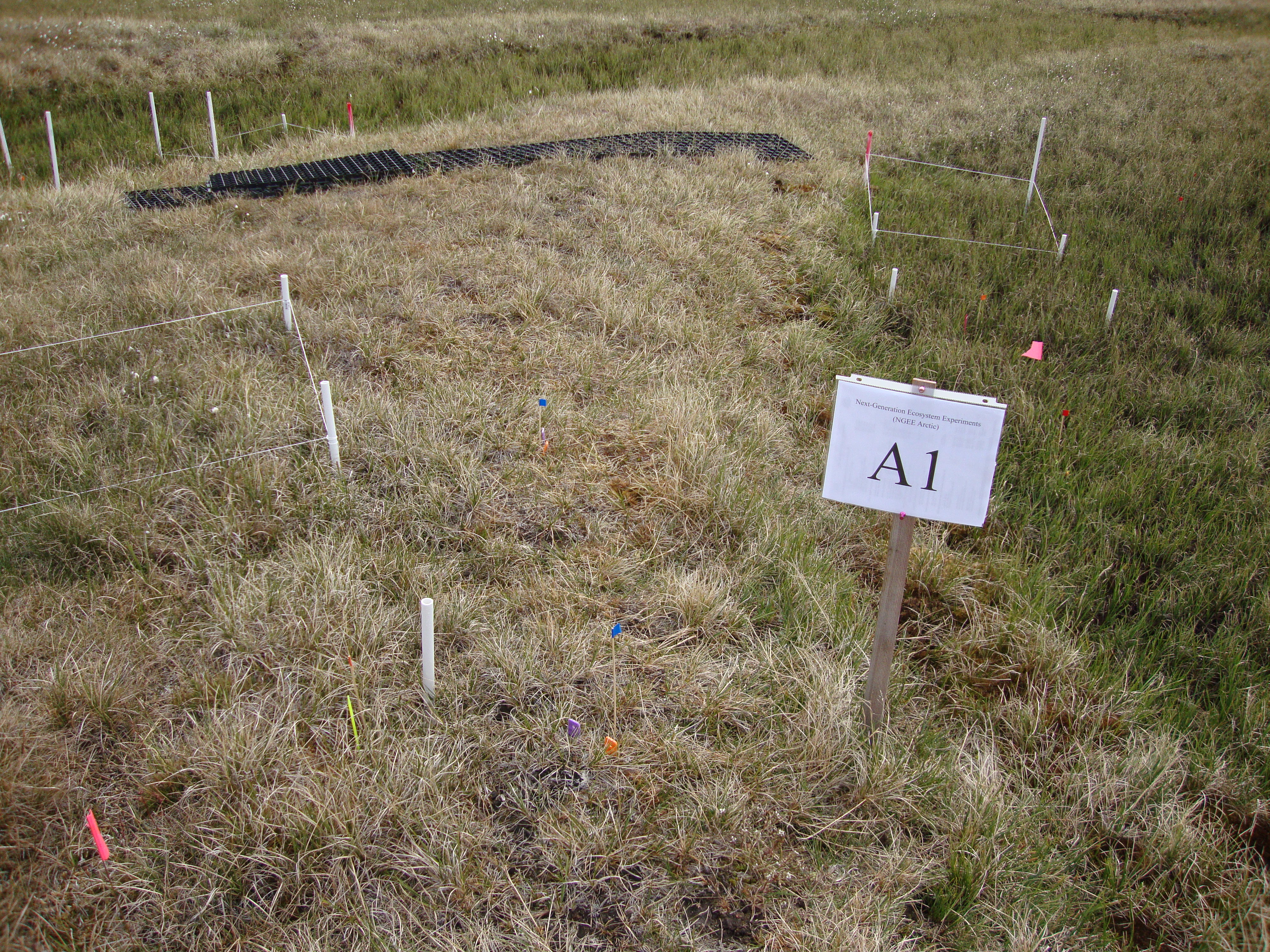
Arctic Vegetation Plots for NGEE-Arctic at Barrow, Alaska, 2012
National Aeronautics and Space Administration —
This data set provides vegetation cover and environmental plot data collected on the Barrow Environmental Observatory (BEO), Barrow, Alaska in 2012. Forty-eight 1 x 1... -
Federal
Aboveground Biomass Density for High Latitude Forests from ICESat-2, 2020
National Aeronautics and Space Administration —
This dataset provides estimates of Aboveground dry woody Biomass Density (AGBD) for high northern latitude forests at a 30-m spatial resolution. It is designed both... -
Federal
BOREAS SERM Forest Cover Data Layers of the SSA in Vector Format
National Aeronautics and Space Administration —
The forest cover data provided by Saskatchewan Environment and Resource Management, Forestry Branch - Inventory Unit (SERM-FBIU) are basically a digital version of... -
Federal
ABoVE: Lake Growing Season Green Surface Reflectance Trends, AK and Canada, 1984-2019
National Aeronautics and Space Administration —
This dataset provides an annual time series of Landsat green surface reflectance and the derived annual trend during the growing season (June and July) for 472,890... -
Federal
LBA-ECO LC-07 Wetland Extent, Vegetation, and Inundation: Lowland Amazon Basin
National Aeronautics and Space Administration —
This data set provides a map of wetland extent, vegetation type, and dual-season flooding state of the entire lowland Amazon basin. As described in Hess et al.... -
Federal
AVIRIS Facility Instruments: Flight Line Geospatial and Contextual Data
National Aeronautics and Space Administration —
This dataset provides attributed geospatial and tabular information for identifying and querying flight lines of interest for the Airborne Visible InfraRed Imaging... -
Federal
Northern and Mid-Latitude Soil Database, Version 1, R1
National Aeronautics and Space Administration —
The U.S. Department of Agriculture, Agriculture and Agri-Food Canada, the Russian Academy of Agricultural Sciences, the University of Copenhagen Institute of... -
Federal
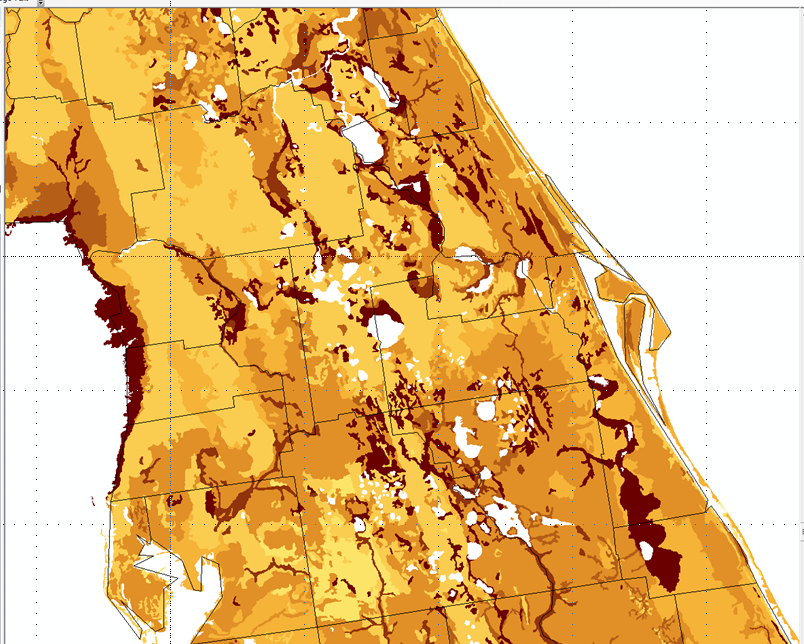
NACP Peatland Land Cover Map of Upper Peninsula, Michigan, 2007-2011
National Aeronautics and Space Administration —
This dataset provides a land cover map focused on peatland ecosystems in the upper peninsula of Michigan. The map was produced at 12.5-m resolution using a multi-... -
Federal
BOREAS CanSIS Regional Soils Data in Vector Format, V2
National Aeronautics and Space Administration —
This data set contains soils data from the Canada Soil Information System (CanSIS) in ESRI Shapefile format for the provinces of Saskatchewan and Manitoba. They are... -
Federal
Soil Carbon Estimates in 20-cm Layers to 1-meter Depth, Conterminous US, 1970-1993
National Aeronautics and Space Administration —
This data set provides a soil map with estimates of soil carbon (C) in g C/m2 for 20-cm layers from the surface to one meter depth for the conterminous United... -
Federal
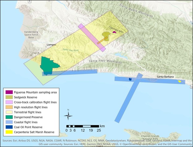
SHIFT: Vegetation Plot Characterization, Santa Barbara County, CA, 2022
National Aeronautics and Space Administration —
This dataset contains vegetation plot locations, descriptions, fractional cover, and sample identifier information from surveys conducted as part of the 2022 NASA... -
Federal
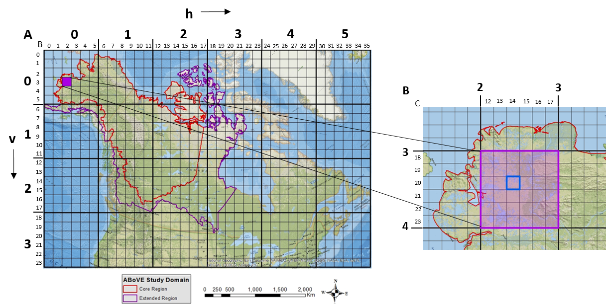
ABoVE: Study Domain and Standard Reference Grids, Version 2
National Aeronautics and Space Administration —
The Arctic - Boreal Vulnerability Experiment (ABoVE) has developed two standardized spatial data products to expedite coordination of research activities and to... -
Federal
BOREAS Follow-On DSP-10 Regridded Peatland Maps
National Aeronautics and Space Administration —
These images were produced by aggregating 1' gridded data layers derived from the polygon-based Peatlands of Canada Database (Tarnocai et al., 2000) to 10'... -
Federal
ABoVE: Lake and Pond Extents in Alaskan Boreal and Tundra Subregions, 2019-2021
National Aeronautics and Space Administration —
This dataset provides polygon spatial files of lake and pond extents for three sub-regions of Interior Alaska's boreal forest, and one tundra region located in... -
Federal
LBA-ECO LC-07 Monthly Inundated Areas, Amazon, Orinoco and Pantanal Basins: 1978-1987
National Aeronautics and Space Administration —
This data set reports the monthly record of inundated area, in square km, for six floodplain and open water regions in South America. The following floodplains were... -
Federal
LBA-ECO LC-22 Field Validation of MODIS Deforestation Detection, Brazil, 2005
National Aeronautics and Space Administration —
This data set contains field observations, corresponding GPS points, and point and polygons of deforested areas in the state of Mato Grosso, Brazil, for the period... -
Federal
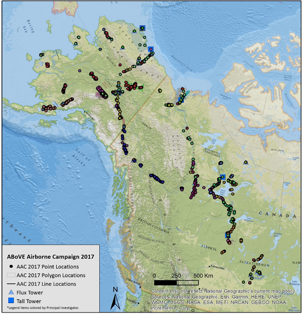
ABoVE: Directory of Field Sites Associated with 2017 ABoVE Airborne Campaign
National Aeronautics and Space Administration —
This dataset provides a listing of the ~6,700 field sites used in planning the ABoVE Airborne Campaign (AAC) for 2017. The sites included point, polygon, and line...

Official websites use .gov
A
.gov website belongs to an official government
organization in the United States.
Secure .gov websites use HTTPS
A
lock (
) or https:// means you’ve safely connected to
the .gov website. Share sensitive information only on official,
secure websites.