
-
Federal
A Global Database of Gas Fluxes from Soils after Rewetting or Thawing, Version 1.0
National Aeronautics and Space Administration —
This database contains information compiled from published studies on gas flux from soil following rewetting or thawing. The resulting database includes 222 field and... -
Federal
Global Hydrologic Soil Groups (HYSOGs250m) for Curve Number-Based Runoff Modeling
National Aeronautics and Space Administration —
This dataset - HYSOGs250m - represents a globally consistent, gridded dataset of hydrologic soil groups (HSGs) with a geographical resolution of 1/480 decimal... -
Federal
Leaf Area Index Maps at 30-m Resolution, VALERI Site, Larose, Canada
National Aeronautics and Space Administration —
This data set provide local LAI maps for the Larose (Ontario) site in Canada. These derived maps may also be useful for validating other LAI maps over this same site... -
Federal
Soil Organic Carbon Stock Estimates with Uncertainty across Latin America
National Aeronautics and Space Administration —
This dataset provides 5 x 5 km gridded estimates of soil organic carbon (SOC) across Latin America that were derived from existing point soil characterization data... -
Federal
Global Distribution of Plant-Extractable Water Capacity of Soil (Dunne)
National Aeronautics and Space Administration —
Plant-extractable water capacity of soil is the amount of water that can be extracted from the soil to fulfill evapotranspiration demands. It is often assumed to be... -
Federal
SAFARI 2000 Stem and Canopy Characterization, Kalahari Transect, 1995-2000
National Aeronautics and Space Administration —
This data set provides species distribution, basal area, height, and crown cover of woody stems at 10 sites along the Kalahari Transect where a large gradient in both... -
Federal
SAFARI 2000 Biomass Burning Emissions, Selected Sites, Dry Season 2000
National Aeronautics and Space Administration —
Biomass burning is a major source for gaseous and particulate atmospheric pollution over southern Africa and globally. The purpose of this study was to quantify... -
Federal
SHIFT: Wetland Spectra, Salinity, and Fractional Cover, Devereux Slough, CA, 2022
National Aeronautics and Space Administration —
This dataset includes field data, analysis code, and corresponding airborne imagery collected and generated during the 2022 NASA Surface Biology Geology (SBG) High... -
Federal
Gamma Ray Data: Peck (FIFE)
National Aeronautics and Space Administration —
Airborne soil moisture measurement is based on the difference between natural terrestrial gamma radiation flux measured for comparatively wet and dry soils. The... -
Federal
LBA Regional Carbon in Live Vegetation, 0.5-degree (Olson)
National Aeronautics and Space Administration —
This data set is a subset of Olson et al. (1985, 2000) "Major World Ecosystem Complexes Ranked by Carbon in Live Vegetation." This subset was created for the study... -
Federal
LBA-ECO ND-02 Secondary Forest Small Stem, Non-Woody Biomass, Para, Brazil: 1999-2005
National Aeronautics and Space Administration —
This data set reports biomass from small stems and non-woody vegetation measured from 1999 to 2005 in plots of a secondary-growth forest fertilization experiment. The... -
Federal
LBA-ECO ND-11 Forest Soil Structure and Nitrate, NW Mato Grosso, Brazil: 2004-2005
National Aeronautics and Space Administration —
This data set reports the results of the analysis of soil samples for Nitrate (NO3) and physical properties that were collected for one year following reduced impact... -
Federal
Canopy Height and Biomass from LiDAR Surveys at La Selva, Costa Rica, 1998 and 2005
National Aeronautics and Space Administration —
This data set contains land-use, canopy height, and aboveground carbon estimates derived from LiDAR data collected at La Selva Biological Station in Costa Rica in... -
Federal
LBA-ECO LC-07 Wetland Extent, Vegetation, and Inundation: Lowland Amazon Basin
National Aeronautics and Space Administration —
This data set provides a map of wetland extent, vegetation type, and dual-season flooding state of the entire lowland Amazon basin. As described in Hess et al.... -
Federal
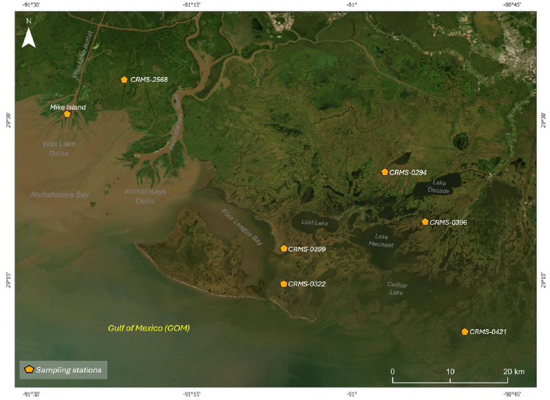
Delta-X: Soil Accretion Rates from Cs-137 Activity and NUMAR Validation, MRD, LA
National Aeronautics and Space Administration —
This dataset holds measurements of Cesium-137 (137Cs) activity sampled from sites in the Atchafalaya and Terrebonne Basins on the southern coast of Louisiana, USA.... -
Federal
LBA-ECO LC-23 Vegetation Fire Data, Roraima , Brazil: 2003
National Aeronautics and Space Administration —
The ASTER high resolution satellite data are available for visible-near infrared (15m resolution), short wave infrared (30m), and thermal infrared (90m) bands. Two... -
Federal
LBA-ECO CD-03 Flux-Meteorological Data, km 77 Pasture Site, Para, Brazil: 2000-2005
National Aeronautics and Space Administration —
Eddy correlation and micrometeorological measurements began in 2001 and continued through 2005 at the pasture site at km 77 on BR-163 just south of the city of... -
Federal
Soil Matric Potential, Dielectric, and Physical Properties, Arctic Alaska, 2018
National Aeronautics and Space Administration —
This dataset provides lab-measured soil properties, including soil water matric potential, soil dielectric properties, soil electrical conductivity, corresponding... -
Federal
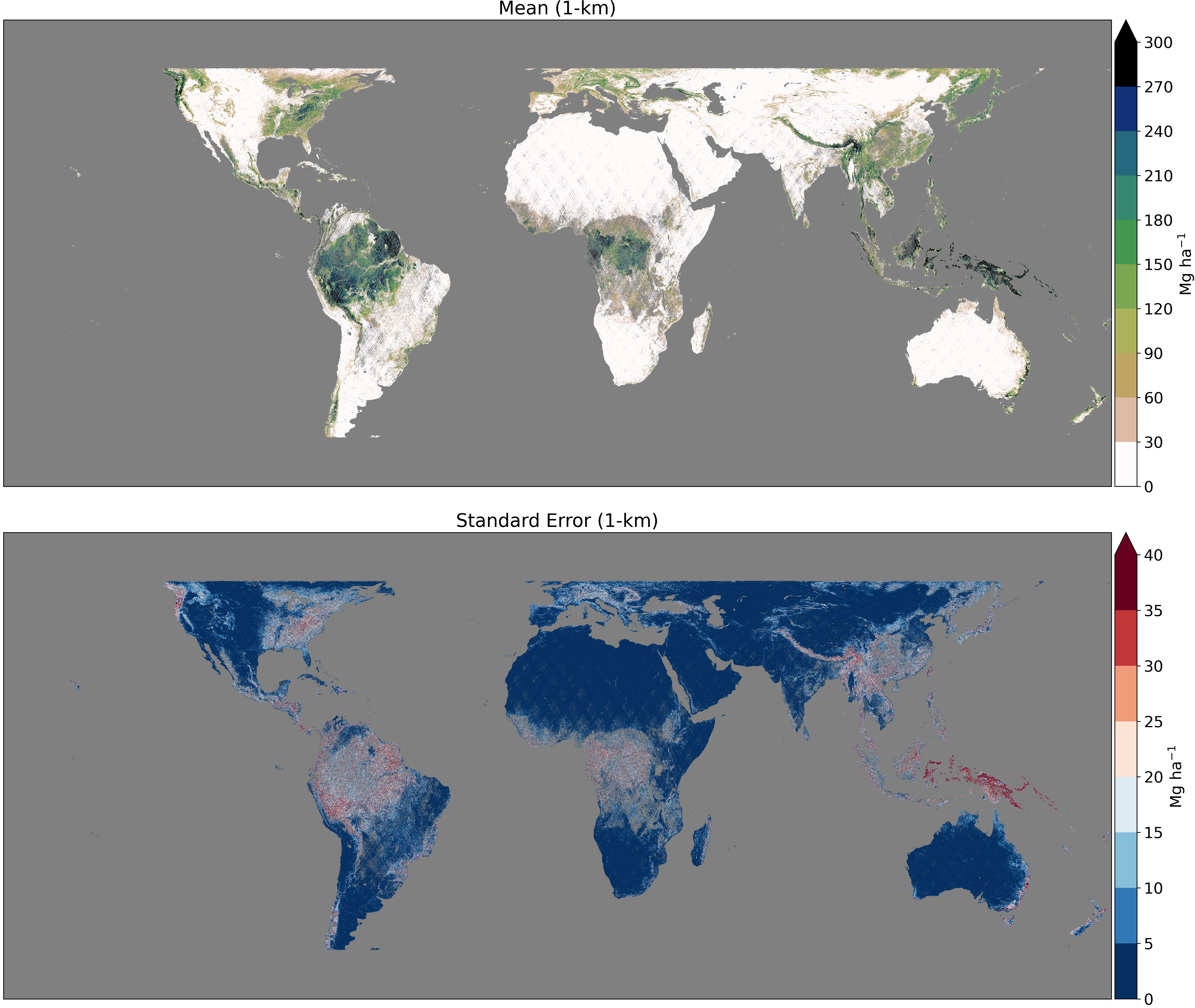
GEDI L4B Gridded Aboveground Biomass Density, Version 2.1
National Aeronautics and Space Administration —
This Global Ecosystem Dynamics Investigation (GEDI) L4B product provides 1 km x 1 km (1 km, hereafter) estimates of mean aboveground biomass density (AGBD) based on... -
Federal
LBA-ECO ND-11 Litter Decomposition, Carbon, and Nitrogen Dynamics in Agroforestry
National Aeronautics and Space Administration —
It has been proposed that the C/N ratio, or quality, of litter or mulch mixtures affects N release. Although total N release from these mixtures and the effects on...

Official websites use .gov
A
.gov website belongs to an official government
organization in the United States.
Secure .gov websites use HTTPS
A
lock (
) or https:// means you’ve safely connected to
the .gov website. Share sensitive information only on official,
secure websites.