
-
Federal
MLS/Aura Level 3 Daily Binned Chlorine Monoxide (ClO) Mixing Ratio on Assorted Grids V005 (ML3DBCLO) at GES DISC recent views
National Aeronautics and Space Administration —
ML3DBCLO is the EOS Aura Microwave Limb Sounder (MLS) daily binned on various vertical grids product for chlorine monoxide (ClO) derived from radiances measured... -
Federal
MLS/Aura Level 3 Daily Binned Hypochlorous Acid (HOCl) Mixing Ratio on Assorted Grids V005 (ML3DBHOCL) at GES DISC recent views
National Aeronautics and Space Administration —
ML3DBHOCL is the EOS Aura Microwave Limb Sounder (MLS) daily binned on various vertical grids product for hypochlorous acid (HOCl) derived from radiances measured... -
Federal
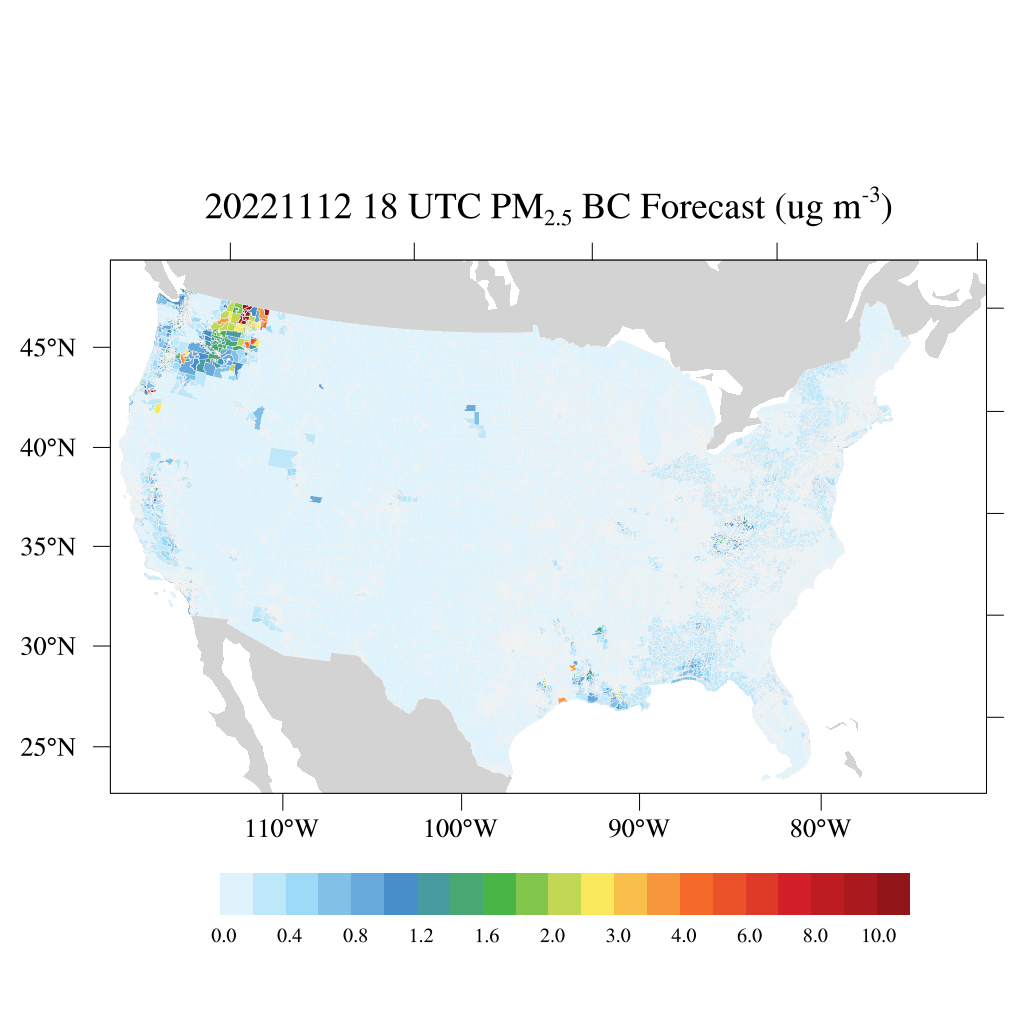
HAQES 3-Hourly Ensemble mean surface PM2.5 Black Carbon concentration at census level, North America V1 (HAQES_NA_PM25_BC_CENSUS) at GES DISC recent views
National Aeronautics and Space Administration —
This product provides HAQES 3-hourly ensemble mean surface PM2.5 Black Carbon concentration at the census level over the continental United States (CONUS). The... -
Federal
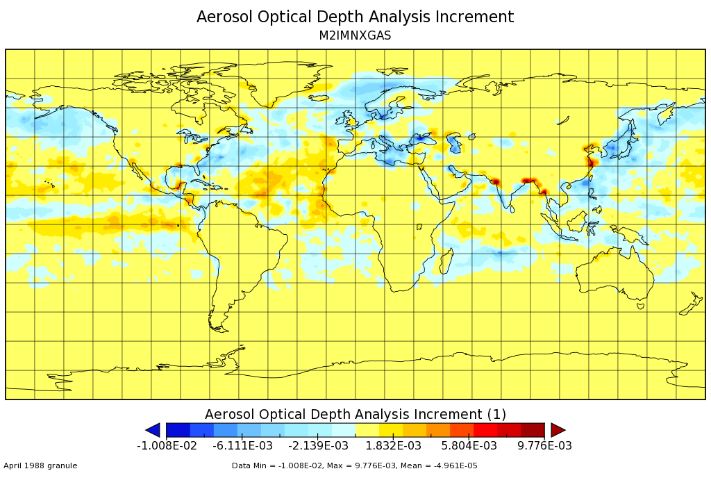
MERRA-2 instM_2d_gas_Nx: 2d,Monthly mean,Instantaneous,Single-Level,Assimilation,Aerosol Optical Depth Analysis 0.625 x 0.5 degree V5.12.4 (M2IMNXGAS) at GES DISC recent views
National Aeronautics and Space Administration —
M2IMNXGAS (or instM_3d_gas_Nx) is an instantaneous 2-dimensional monthly mean data collection in Modern-Era Retrospective analysis for Research and Applications... -
Federal
TROPESS CrIS-SNPP L2 Peroxyacetyl Nitrate for Reanalysis Stream, Summary Product V1 (TRPSYL2PANCRSRS) at GES DISC recent views
National Aeronautics and Space Administration —
The TROPESS CrIS L2 Peroxyacetyl Nitrate for Reanalysis Stream, Summary Product contains the vertical distribution of the retrieved atmospheric state of peroxyacetyl... -
Federal
GPM AMSUB on NOAA17 (GPROF) Climate-based Radiometer Precipitation Profiling L3 1 month 0.25 degree x 0.25 degree V07 (GPM_3GPROFNOAA17AMSUB_CLIM) at GES DISC recent views
National Aeronautics and Space Administration —
The "CLIM" products differ from their "regular" counterparts (without the "CLIM" in the name) by the ancillary data they use. They are Climate-Reference products,... -
Federal
TROPESS AIRS-Aqua L2 Deuterated Water Vapor for Forward Stream, Standard Product V1 (TRPSDL2HDOAIRSFS) at GES DISC recent views
National Aeronautics and Space Administration —
The TROPESS AIRS-Aqua L2 Deuterated Water Vapor for Forward Stream, Standard Product contains the vertical distribution of the retrieved atmospheric state of semi-... -
Federal
GPM SSMIS on F16 Common Calibrated Brightness Temperatures L1C 1.5 hours 12 km V07 (GPM_1CF16SSMIS) at GES DISC recent views
National Aeronautics and Space Administration —
Version 07 is the current version of the data set. Older versions will no longer be available and have been superseded by Version 07. All 1C products have a common... -
Federal
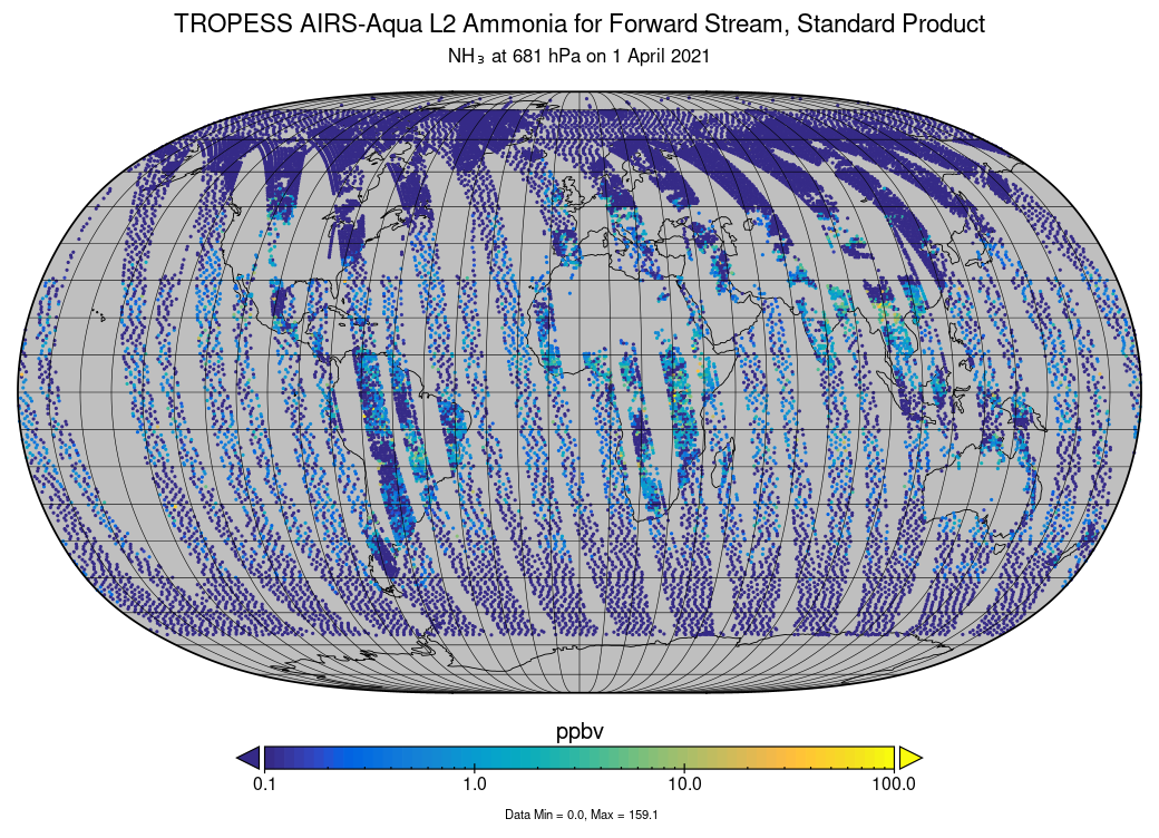
TROPESS AIRS-Aqua L2 Ammonia for Forward Stream, Standard Product V1 (TRPSDL2NH3AIRSFS) at GES DISC recent views
National Aeronautics and Space Administration —
The TROPESS AIRS-Aqua L2 Ammonia for Forward Stream, Standard Product contains the vertical distribution of the retrieved atmospheric state of ammonia (NH3), formal... -
Federal
FLDAS Noah Land Surface Model L4 Global Monthly Anomaly 0.1 x 0.1 degree (MERRA-2 and CHIRPS) V001 (FLDAS_NOAH01_C_GL_MA) at GES DISC recent views
National Aeronautics and Space Administration —
The monthly anomaly data set contains a series of land surface parameters simulated from the Noah 3.6.1 model in the Famine Early Warning Systems Network (FEWS NET)... -
Federal
MODIS Aqua L2 chopped blocks (block size: 128 pixels x 128 pixels, daytime) V001 (MYD_L2_CB) at GES DISC NGDA recent views
National Aeronautics and Space Administration —
This product is composed of a beta version for a product from the MODerate resolution Imaging Spectrometer (MODIS) on board the Aqua satellite. MODIS Aqua L2 chopped... -
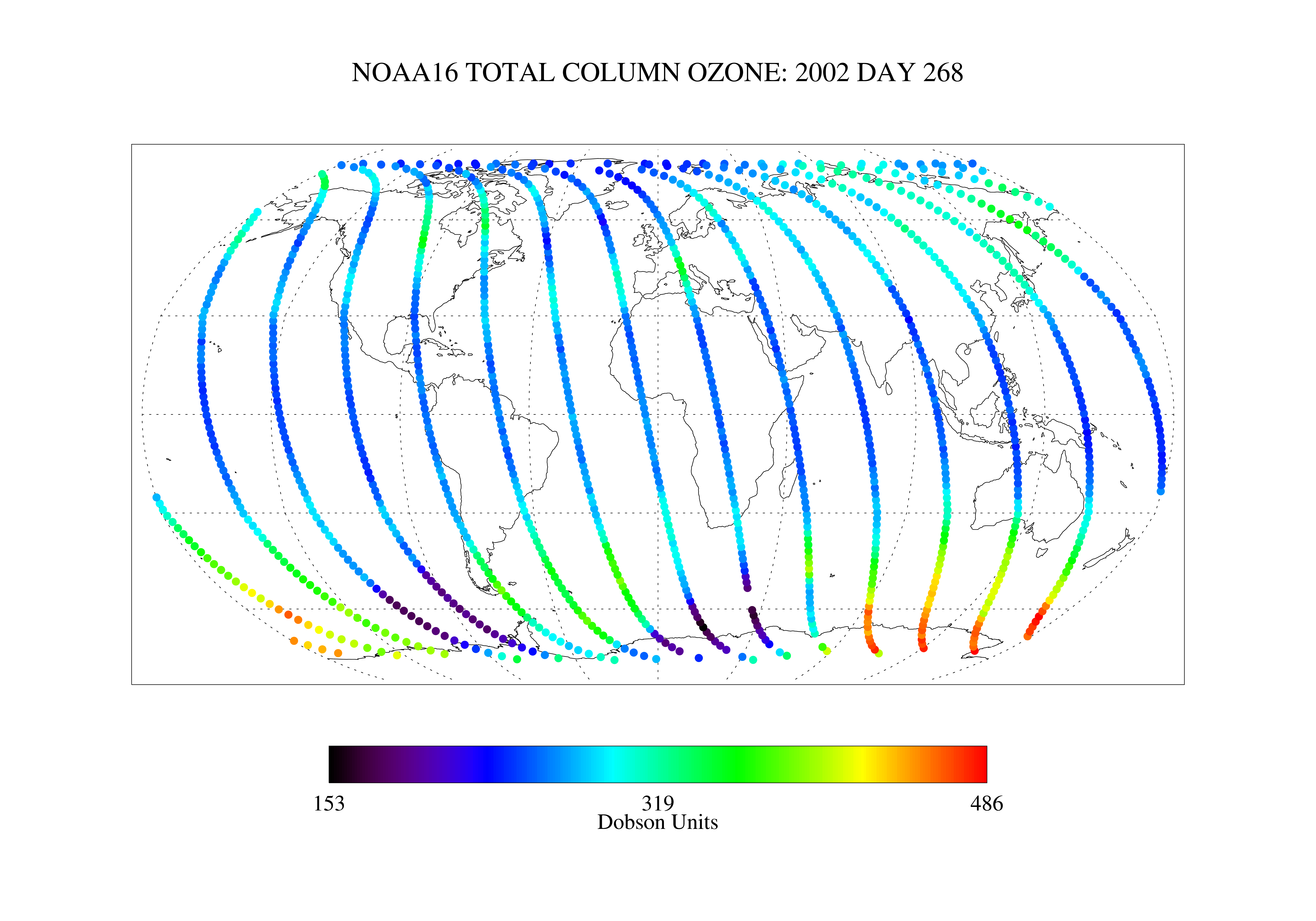
Federal
SBUV2/NOAA-16 Ozone (O3) Nadir Profile and Total Column 1 Day L2 V1 (SBUV2N16L2) at GES DISC recent views
National Aeronautics and Space Administration —
The Solar Backscattered Ultraviolet (SBUV) from NOAA-16 Level-2 daily product (SBUV2N16L2) contains ozone nadir profile and total column data from retrievals... -
Federal
TIROS-4 Medium-Resolution Scanning Radiometer Level 1 Final Meteorological Radiation Data V001 (TIROS4L1FMRT) at GES DISC recent views
National Aeronautics and Space Administration —
TIROS-4 Medium-Resolution Scanning Radiometer Level 1 Final Meteorological Radiation Data (FMRT) product contains radiances expressed in five infrared/visible... -
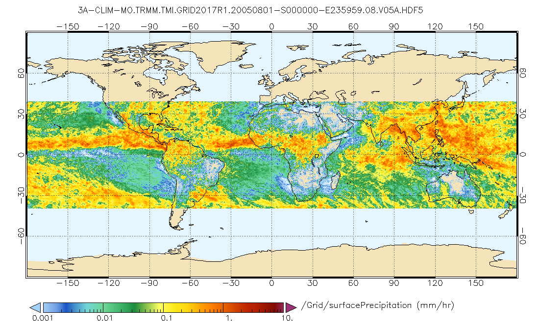
Federal
GPM TMI on TRMM (GPROF) Climate-based Radiometer Precipitation Profiling L3 1 month 0.25 degree x 0.25 degree V07 (GPM_3GPROFTRMMTMI_CLIM) at GES DISC recent views
National Aeronautics and Space Administration —
This is the new (GPM-formated) TRMM product. It replaces the old TRMM_3A12,3A11 Version 07 is the current version of the data set. Older versions will no longer be... -
Federal
GPM PR on TRMM Reflectivity, Precipitation Characteristics and Rate, at Surface and Profile L2 1.5 hours V07 (GPM_2APR) at GES DISC recent views
National Aeronautics and Space Administration —
This is the new, GPM-like, format for TRMM Precipitation Radar L2 data that now incorporates what was known as 2A21, 2A23 and 2A25 datasets. The primary purpose of... -
Federal
THIR/Nimbus-7 Level 1 Cloud Data for SBUV/TOMS V001 (THIRN7L1BCLT) at GES DISC recent views
National Aeronautics and Space Administration —
THIRN7L1BCLT is the Nimbus-7 Temperature-Humidity Infrared Radiometer (THIR) Level 1 Cloud Data for SBUV/TOMS (BCLT) product and contains total cloud amounts;... -
Federal
OCO-3 Level 2 spatially ordered geolocated retrievals screened using the IMAP-DOAS Preprocessor (IDP), Forward Processing V10 (OCO3_L2_IMAPDOAS) at GES DISC recent views
National Aeronautics and Space Administration —
Version 10 is the current version of the data set. Older versions will no longer be available and are superseded by Version 10. The Orbiting Carbon Observatory -3... -
Federal
OCO-2 Level 2 meteorological parameters interpolated from global assimilation model for each sounding, Retrospective Processing V11r (OCO2_L2_Met) at GES DISC recent views
National Aeronautics and Space Administration —
Version 11r is the current version of the data set. Older versions will no longer be available and are superseded by Version 11r. The Orbiting Carbon Observatory is...

Official websites use .gov
A
.gov website belongs to an official government
organization in the United States.
Secure .gov websites use HTTPS
A
lock (
) or https:// means you’ve safely connected to
the .gov website. Share sensitive information only on official,
secure websites.