
-
Federal
EnviroAtlas - 2016 Land Cover Proportions by 12-digit HUC for Alaska
U.S. Environmental Protection Agency —
This EnviroAtlas dataset represents the percentage of land area that is classified as natural, forest, wetland, agricultural, natural, and developed land cover as... -
State
Ground gravity geophysical survey of the Holitna basin area, Alaska, data compilation
State of Alaska —
Gravity data were acquired at 1,175 stations during the period April 13 to May 3, 1982 by EDCON, Inc. using a helicopter-borne inertial surveying system and LaCoste... -
Federal
SnowEx23 Laser Snow Microstructure Specific Surface Area Data V001
National Aeronautics and Space Administration —
Preliminary: This data set reports vertical profiles of snow reflectance and specific surface area (SSA) in Alaska, USA, in two regions, the Fairbanks region... -
Federal
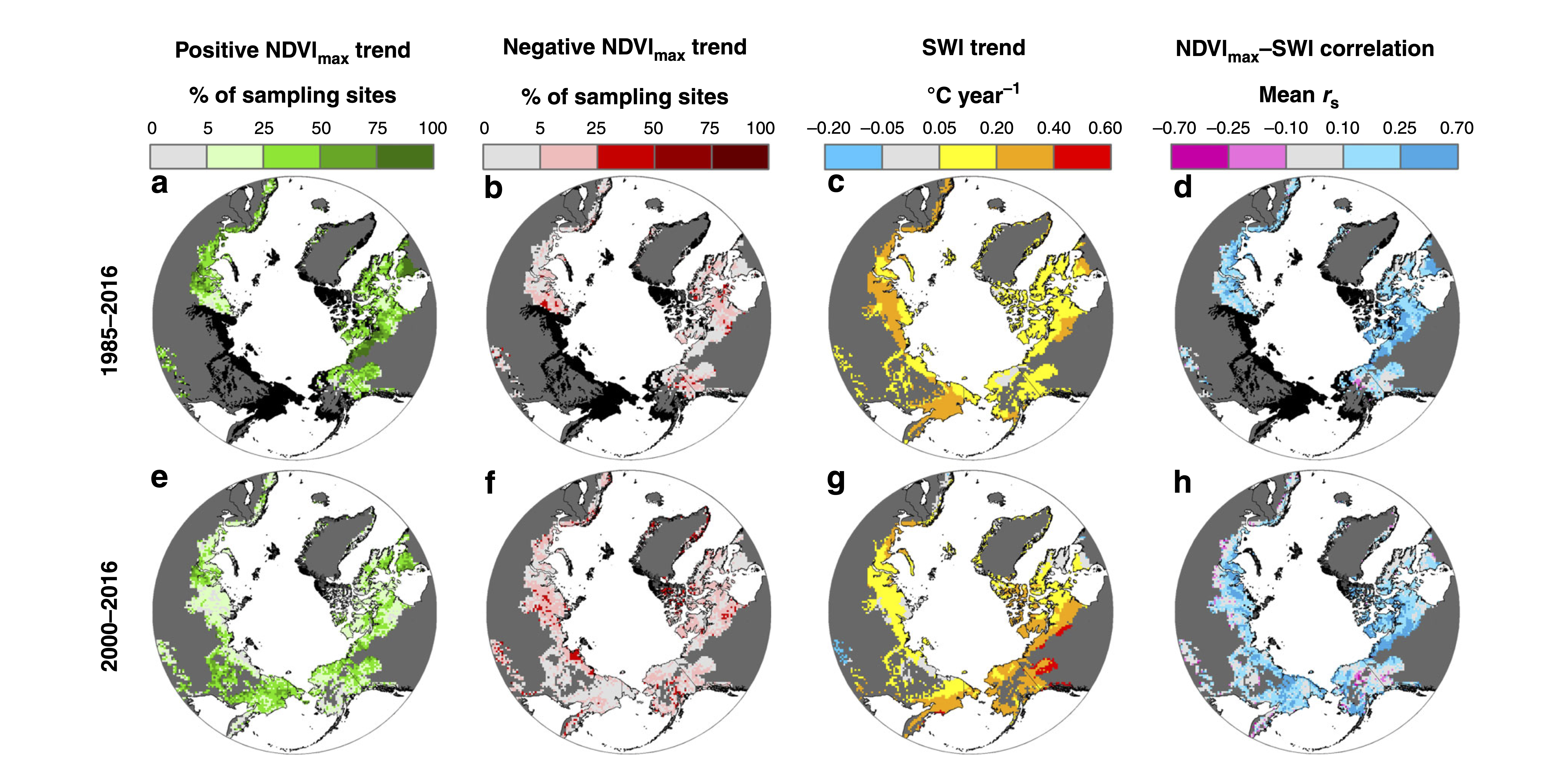
ABoVE: Landsat Tundra Greenness and Summer Air Temperatures, Arctic Tundra, 1985-2016
National Aeronautics and Space Administration —
This dataset provides annual tundra greenness and summer air temperatures at a resolution of 50 km over the pan-Arctic tundra biome above 31.5 degrees over the time... -
State
Geology and geochemistry of the Inmachuk River map area, Seward Peninsula, Alaska
State of Alaska —
Geology and geochemistry of the Inmachuk River map area, Seward Peninsula, Alaska, Geologic Report 23, presents a geological overview of the Inmachuk map area, a... -
Federal
Tracking Data for Whimbrels (Numenius phaeopus)
Department of the Interior —
This data release includes 2 child items with tracking data for Whimbrels, a shorebird found throughout tundra and boreal habitats of Alaska during the summer and... -
Federal
Habitat Selection Scenarios for Molting Waterfowl in the Goose Molting Area of the Teshekpuk Lake Special Area, for NPR-A Integrated Activity Plan/Environmental Impact Statement, 2020
Department of the Interior —
The dataset consists of a polygon shapefile. Each polygon represents a set of molt units (interconnected lakes used as habitat by molting waterfowl) within the Goose... -
Federal
Low-Altitude Photographic Transects of the Arctic Network of National Park Units and Selawik National Wildlife Refuge, Alaska, July 2013
Department of the Interior —
This data release includes 5 child items with photos and videos taken during low altitude photo survey transects in northwest Alaska, July 2013. Three flight... -
Federal
Aerial Photo Imagery from Fall Waterfowl Surveys, Izembek Lagoon, Alaska, 2017-2019
Department of the Interior —
The imagery and annotations presented here were generated while testing an aerial photographic survey design to improve repeatability, transparency, and estimation of... -
Federal
SnowEx23 CRREL Ground Penetrating Radar V001
National Aeronautics and Space Administration —
This data set contains the results of 1 GHz ground-penetrating radar surveys conducted in Alaska, USA as part of the NASA SnowEx 2023 field campaign. The study site... -
Federal
Aerial Images of Alaska's Arctic Coastal Plain, 1948-1949
Department of the Interior —
This dataset is comprised of 35 geo-referenced aerial images of four study areas (Teshekpuk Lake Special Area, Chipp River, Colville River Delta, and Dalton Highway... -
Federal
SnowEx23 Mar23 IOP Community Snow Depth Measurements V001
National Aeronautics and Space Administration —
The data set contains snow depth measurements from five study sites in Alaska, USA; data were collected during the March 2023 intensive observation period (IOP) as... -
Federal
NOAA/WDS Paleoclimatology - Shiyatov - Forest-Tundra Zone Mangazeya Swampy Site - LASI - ITRDB RUSS011
National Oceanic and Atmospheric Administration, Department of Commerce —
This archived Paleoclimatology Study is available from the NOAA National Centers for Environmental Information (NCEI), under the World Data Service (WDS) for... -
Federal
NOAA/WDS Paleoclimatology - Shiyatov - Forest-Tundra Zone Intermediate Moisture Site - LASI - ITRDB RUSS005
National Oceanic and Atmospheric Administration, Department of Commerce —
This archived Paleoclimatology Study is available from the NOAA National Centers for Environmental Information (NCEI), under the World Data Service (WDS) for... -
Federal
SnowEx23 Oct22 Ground Surface Roughness Imagery V001
National Aeronautics and Space Administration —
This data set presents photographs of snow pit ground surface collected using a digital camera during the NASA SnowEx 2023 field campaign between 23 and 25 October... -
Federal
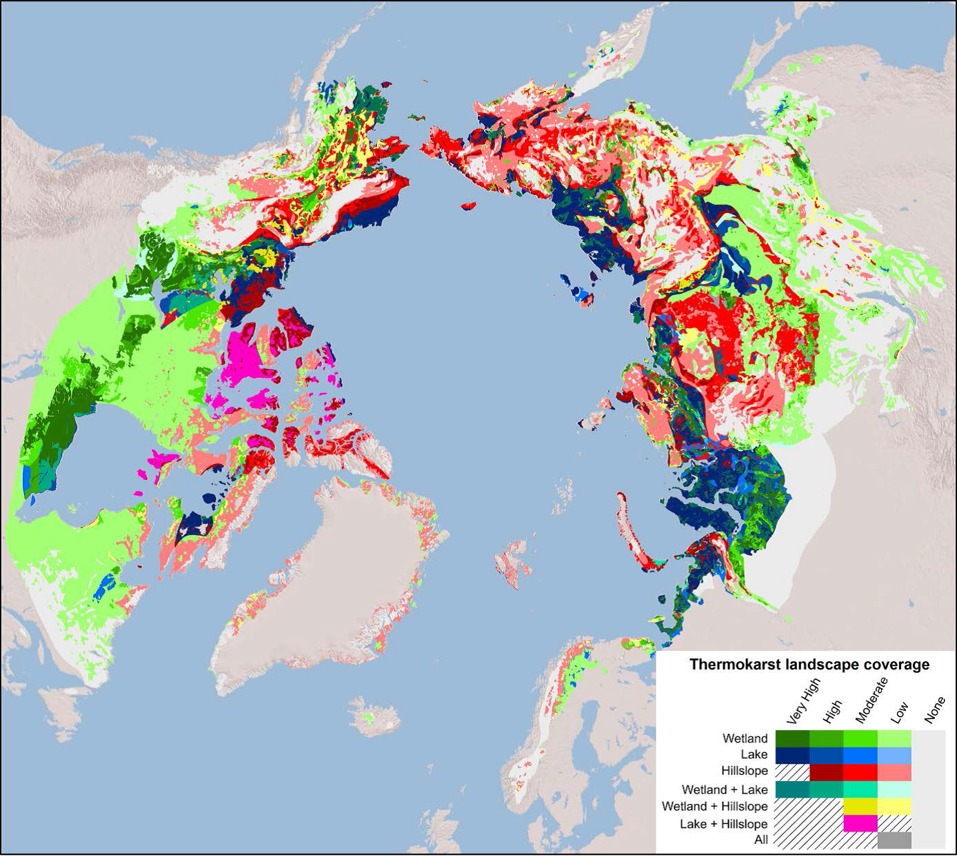
Arctic Circumpolar Distribution and Soil Carbon of Thermokarst Landscapes, 2015
National Aeronautics and Space Administration —
This data set provides the distribution of thermokarst landscapes in the boreal and tundra ecoregions within the northern circumpolar permafrost zones. This dataset... -
Federal
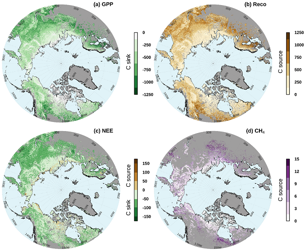
Gridded CO2 and CH4 Flux Estimates for pan-Arctic and Boreal Regions, 2003-2015
National Aeronautics and Space Administration —
This dataset provides gridded estimates of gross primary productivity (GPP), ecosystem respiration (Reco), net ecosystem CO2 exchange (NEE = Reco - GPP), and methane... -
State
Tundra Swan Predicted Habitat - CWHR B067 [ds2049]
State of California —
The datasets used in the creation of the predicted Habitat Suitability models includes the CWHR range maps of Californias regularly-occurring vertebrates which were... -
Federal
Emperor Goose (Anser canagicus) Nest Survival Encounter History from the Yukon-Kuskokwim Delta, Alaska, 1994-2017
Department of the Interior —
These data are in four tables relating to nest visit data of Emperor Geese on the Yukon-Kuskokwim Delta in Alaska, 1994-2017. The tables provide: (1) nest visit and... -
Federal
Capture and Measurement Data of Greater White-Fronted Geese (Anser albifrons) from the Arctic Coastal Plain of Alaska, 2012-2014
Department of the Interior —
This data set provides capture information and body size measurements of adult and gosling Greater White-fronted Geese captured at three study sites on the Arctic...

Official websites use .gov
A
.gov website belongs to an official government
organization in the United States.
Secure .gov websites use HTTPS
A
lock (
) or https:// means you’ve safely connected to
the .gov website. Share sensitive information only on official,
secure websites.