
-
Federal
Delta-X: Bed and Suspended Sediment Grain Size, MRD, LA, USA, 2019-2021, V3
National Aeronautics and Space Administration —
This dataset includes sediment concentration and grain size distribution measurements from suspended and bed sediment samples collected in the Atchafalaya River and... -
State
Harbor Seals [ds106]
State of California —
In May of 2001, the California Department of Fish and Game (CDFG) conducted an aerial photographic survey of the California coast and the offshore Channel Islands to... -
Federal
H11498: NOS Hydrographic Survey , Approaches to Cordova, Alaska, 2005-09-24
National Oceanic and Atmospheric Administration, Department of Commerce —
The National Oceanic and Atmospheric Administration (NOAA) has the statutory mandate to collect hydrographic data in support of nautical chart compilation for safe... -
Federal
CERES and GEO-Enhanced TOA, Within-Atmosphere and Surface Fluxes, Clouds and Aerosols 1-Hourly Terra-NOAA20 Edition4A
National Aeronautics and Space Administration —
CER_SYN1deg-1Hour_Terra-NOAA20-MODIS_Edition4A is the Clouds and the Earth's Radiant Energy System (CERES) and geostationary (GEO) Top-of-Atmosphere (TOA) Within-... -
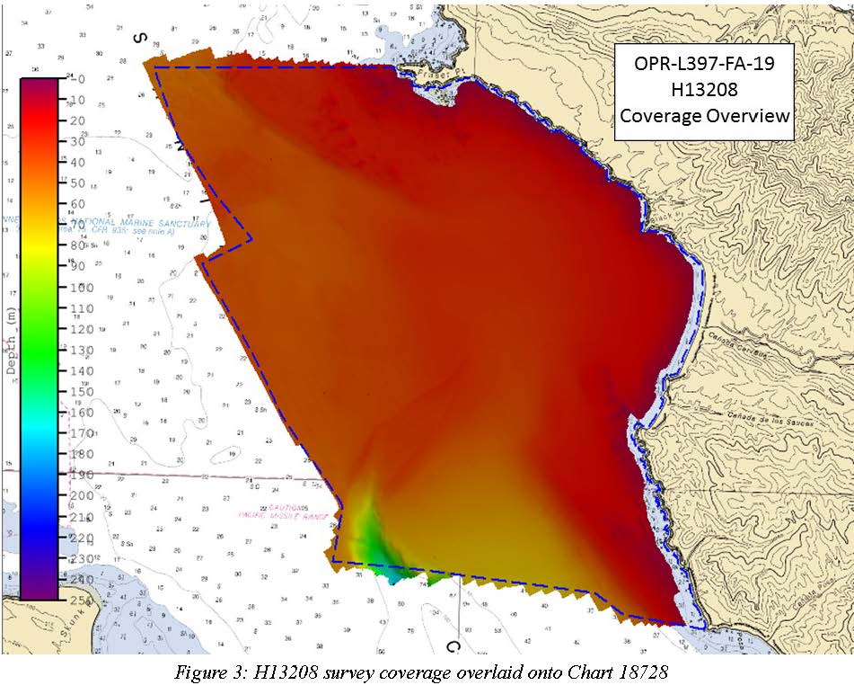
Federal
H13208: NOS Hydrographic Survey , 2019-10-14
National Oceanic and Atmospheric Administration, Department of Commerce —
The National Oceanic and Atmospheric Administration (NOAA) has the statutory mandate to collect hydrographic data in support of nautical chart compilation for safe... -
Federal
Coastal Maintained Channels in US waters
National Oceanic and Atmospheric Administration, Department of Commerce —
This layer shows coastal channels and waterways that are maintained and surveyed by the U.S. Army Corps of Engineers (USACE). These channels are necessary... -
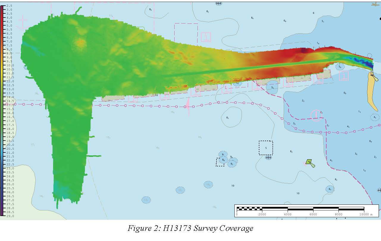
Federal
H13173: NOS Hydrographic Survey , 2019-07-21
National Oceanic and Atmospheric Administration, Department of Commerce —
The National Oceanic and Atmospheric Administration (NOAA) has the statutory mandate to collect hydrographic data in support of nautical chart compilation for safe... -
Federal
1993 Average Monthly Sea Surface Temperature for California
National Oceanic and Atmospheric Administration, Department of Commerce —
The NOAA/NASA AVHRR Oceans Pathfinder sea surface temperature data are derived from the 5-channel Advanced Very High Resolution Radiometers (AVHRR) on board the NOAA... -
Federal
Measurement Dataset for A Wireless Gantry System
National Institute of Standards and Technology —
This dataset includes the position data of a two-dimensional gantry system experiment in which the G-code commands for the gantry were transmitted through a wireless... -
Federal
Uplink IQ Recordings
Department of Commerce —
This data is provided as a supplement to NIST Technical Note 2159 Laboratory Method for Recording AWS-3 LTE Waveforms available at... -
Federal
Fish diversity in central and southern California using fish catch and effort data from the Recreational Fisheries Information Network
National Oceanic and Atmospheric Administration, Department of Commerce —
This dataset was provided by the Recreational Fisheries Information Network (RecFIN), and contained GPS coordinates for 680 CPFV trips during 1999 and 2001 at depths... -
Federal
Dominant Benthic Structure and Biological Cover Habitat Maps for West Maui and West Hawaii
National Oceanic and Atmospheric Administration, Department of Commerce —
Benthic habitat maps depict dominant substrate type and biological cover in depths between 0 and ~150 m for two priority sites in the Main Hawaiian Islands; the NOAA... -
Federal
NARSTO PAC2001 NRC-IAR Convair 580 Particle Count, Ozone, Meteorological Data
National Aeronautics and Space Administration —
NARSTO_PAC2001_CONVAIR_PM_OZONE_MET_DATA is the North American Research Strategy for Tropospheric Ozone (NARSTO) Pacific 2001 Air Quality Study (PAC2001) Convair... -
Federal
Map of percent scleractinian coral cover and sand along camera tows and ROV tracks of West Maui, Hawaii
National Oceanic and Atmospheric Administration, Department of Commerce —
This map displays optical validation observation locations and percent coverage of scleractinian coral and sand overlaid on bathymetry and landsat imagery. Optical... -
Federal
Modeling MCPTT and User Behavior in ns-3
National Institute of Standards and Technology —
This dataset contains the raw data for the paper: Garey, W.; Henderson, T.; Sun, Y.; Rouil, R. and Gamboa, S. (2021). Modeling MCPTT and User Behavior in ns-3. In... -
Federal
NCCN Landscape Dynamics Monitoring MORA geospatial data 1985-2009
Department of the Interior —
NOTE: this version, V2B, has been REPLACED by reference 2294375: https://irma.nps.gov/DataStore/Reference/Profile/2294375. The 2294375 replacement was derived using... -
Federal
CERES and GEO-Enhanced TOA, Within-Atmosphere and Surface Fluxes, Clouds and Aerosols Monthly-Averaged 1-Hourly Terra-NOAA20 Edition4A
National Aeronautics and Space Administration —
CER_SYN1deg-MHour_Terra-NOAA20_Edition4A is the Clouds and the Earth's Radiant Energy System (CERES) and geostationary (GEO)-Enhanced Top-of-Atmosphere (TOA), Within-... -
Federal
CERES and GEO-Enhanced TOA, Within-Atmosphere and Surface Fluxes, Clouds and Aerosols 1-Hourly Terra-Aqua-NOAA20 Edition4B
National Aeronautics and Space Administration —
CER_SYN1deg-1Hour_Terra-Aqua-NOAA20_Edition4B is the Clouds and the Earth's Radiant Energy System (CERES) and geostationary (GEO) Top-of-Atmosphere (TOA) Within-... -
Federal
BLM UT GRSG Seasonal Habitats (Polygon)
Department of the Interior —
This polygon feature class represents the spatial extent and boundaries for the Utah Greater Sage-Grouse (GRSG) seasonal habitats, as modeled by the Utah State... -
Federal
H13852: NOS Hydrographic Survey , 2024-05-15
National Oceanic and Atmospheric Administration, Department of Commerce —
The National Oceanic and Atmospheric Administration (NOAA) has the statutory mandate to collect hydrographic data in support of nautical chart compilation for safe...

Official websites use .gov
A
.gov website belongs to an official government
organization in the United States.
Secure .gov websites use HTTPS
A
lock (
) or https:// means you’ve safely connected to
the .gov website. Share sensitive information only on official,
secure websites.