
-
Federal
NEOWAVE Regional Tsunami Model: South Hawaii PMT: Hawaii: Hawaii Island: Kapoho
National Oceanic and Atmospheric Administration, Department of Commerce —
Non-hydrostatic Evolution of Ocean WAVEs (NEOWAVE) regional tsunami model for the eastern point of Hawaii Island in the State of Hawaii, stretching from Kahena Beach... -
Federal
GRIP Hurricane and Tropical Storm Forecasts V1
National Aeronautics and Space Administration —
The GRIP Hurricane and Tropical Storm Forecasts dataset consists of tropical cyclone model forecast tracks archived during the NASA Genesis and Rapid Intensification... -
Federal
NEOWAVE Regional Tsunami Model: South Hawaii PMT: Hawaii: Kauai
National Oceanic and Atmospheric Administration, Department of Commerce —
Non-hydrostatic Evolution of Ocean WAVEs (NEOWAVE) regional tsunami model for Kauai County in the State of Hawaii, which includes the islands of Kauai and Niihau.... -
Federal
Global High Resolution Daily Extreme Urban Heat Exposure (UHE-Daily), 1983-2016
National Aeronautics and Space Administration —
The Global High Resolution Daily Extreme Urban Heat Exposure (UHE-Daily), 1983-2016 data set contains a high-resolution, longitudinal global record of geolocated... -
Federal
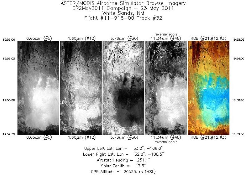
MASTER: Student Airborne Research Program (SARP) campaign, California, USA, 2016
National Aeronautics and Space Administration —
This dataset includes Level 1B (L1B) data products from the MODIS/ASTER Airborne Simulator (MASTER) instrument collected and developed by the Student Airborne... -
Federal
Global Drought Total Economic Loss Risk Deciles
National Aeronautics and Space Administration —
The Global Drought Total Economic Loss Risk Deciles is a 2.5 minute grid of global drought total economic loss risks. A process of spatially allocating Gross Domestic... -
Federal
Global Cyclone Mortality Risks and Distribution
National Aeronautics and Space Administration —
The Global Cyclone Mortality Risks and Distribution is a 2.5 minute grid of global cyclone mortality risks. Gridded Population of the World, Version 3 (GPWv3) data... -
Federal
Hawaii and Pacific Islands King Tides Project
National Oceanic and Atmospheric Administration, Department of Commerce —
The University of Hawaii Sea Grant College Program's Hawaii and Pacific Islands King Tides Project documents high water level events known as King Tides to better... -
Federal
BLM AZ Areas of Critical Environmental Concern
Department of the Interior —
ACECs are authorized in Section 202 (c)(3) of the Federal Land Policy and Management Act of 1976 (FLPMA, P.L. 94-579). ACECs include public lands where special... -
Federal
LBA-ECO LC-02 GOES-08 Hot Pixel Data from Acre, Brazil: 1998, 2000, and 2001
National Aeronautics and Space Administration —
This data set provides hot pixel data, as an indicator of fires that were detected by the GOES-8 satellite for the state of Acre, Brazil. Image data were collected... -
Federal
Archival and Discovery of August 27, 1883 Tsunami Event on Marigrams
National Oceanic and Atmospheric Administration, Department of Commerce —
NOAA National Centers for Environmental Information have more than 3,000 tsunami marigram (tide gauge) records in both image and paper format. The majority of these... -
Federal
Gateway National Weather Service (NWS) Service Records and Retention System (SRRS)
National Oceanic and Atmospheric Administration, Department of Commerce —
The Service Records Retention System (SRRS) was developed to store weather observations, summaries, forecasts, warnings, and advisories provided by the U.S. National... -
Federal
NOAA GOES-R Series Advanced Baseline Imager (ABI) Level 3 Daily River and Surface Flood Map Products (RSVFM)
National Oceanic and Atmospheric Administration, Department of Commerce —
The purpose of this collection is to provide researchers and near real-time users, a daily view of river and standing water flooding over the Americas. On the GOES-R... -
Federal
Global Drought Proportional Economic Loss Risk Deciles
National Aeronautics and Space Administration —
The Global Drought Proportional Economic Loss Risk Deciles is a 2.5 minute grid of drought hazard economic loss as proportions of Gross Domestic Product (GDP) per... -
Federal
NEOWAVE Regional Tsunami Model: South Hawaii PMT: Hawaii: Oahu
National Oceanic and Atmospheric Administration, Department of Commerce —
Non-hydrostatic Evolution of Ocean WAVEs (NEOWAVE) regional tsunami model for the island of Oahu in the State of Hawaii. Provides a nearshore hazard map of wave... -
Federal
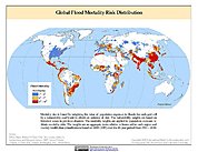
Global Flood Mortality Risks and Distribution
National Aeronautics and Space Administration —
The Global Flood Mortality Risks and Distribution is a 2.5 minute grid of global flood mortality risks. Gridded Population of the World, Version 3 (GPWv3) data... -
Federal
BOSZ Wave-Driven Sea Level Rise Inundation: West Maui
National Oceanic and Atmospheric Administration, Department of Commerce —
A new modeling approach was implemented here to simulate wave-induced coastal inundation. Using the Boussinesq Ocean and Surf Zone (BOSZ) phase-resolving model, we... -
Federal
NEOWAVE Regional Tsunami Model: Kalapana 1975: Hawaii: Hawaii Island: Punaluu
National Oceanic and Atmospheric Administration, Department of Commerce —
Non-hydrostatic Evolution of Ocean WAVEs (NEOWAVE) regional tsunami model for the south-southeast coast of Hawaii Island in the State of Hawaii, stretching from...

Official websites use .gov
A
.gov website belongs to an official government
organization in the United States.
Secure .gov websites use HTTPS
A
lock (
) or https:// means you’ve safely connected to
the .gov website. Share sensitive information only on official,
secure websites.