
-
Federal
NOAA Next Generation Radar (NEXRAD) Level 3 Products recent views
National Oceanic and Atmospheric Administration, Department of Commerce —
This dataset consists of Level 3 weather radar products collected from Next-Generation Radar (NEXRAD) stations located in the contiguous United States, Alaska,... -
Federal
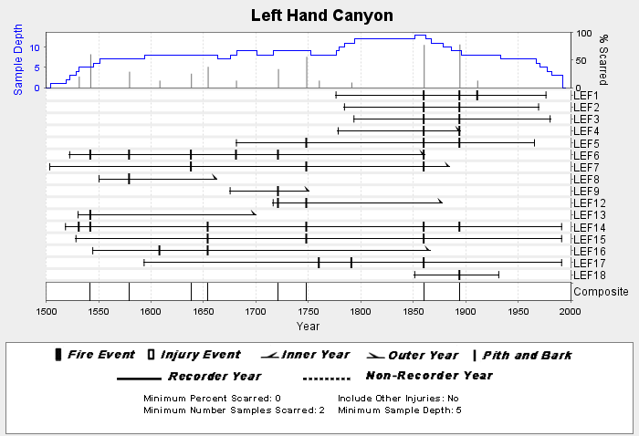
NOAA/WDS Paleoclimatology - Brown fire data from Left Hand Canyon - IMPD USLEF001 recent views
National Oceanic and Atmospheric Administration, Department of Commerce —
This archived Paleoclimatology Study is available from the NOAA National Centers for Environmental Information (NCEI), under the World Data Service (WDS) for... -
Federal
CTD Data recent views
National Oceanic and Atmospheric Administration, Department of Commerce —
Environmental parameters collected during conductivity, temperature and depth (CTD) casts typically performed daily at the end of marine mammal visual observations;.... -
Federal
National Solar Radiation Database (NSRDB) SolarAnywhere 10 km Model Output for 1989 to 2009 recent views
National Oceanic and Atmospheric Administration, Department of Commerce —
The National Solar Radiation Database (NSRDB) was produced by the National Renewable Energy Laboratory under the U.S. Department of Energy's Office of Energy... -
Federal
North Carolina 2016 ESI FISH Polygons, Lines recent views
National Oceanic and Atmospheric Administration, Department of Commerce —
This data set contains sensitive biological resource data for marine, estuarine, anadromous, and freshwater fish species in North Carolina. Vector polygons (FISH... -
Federal
2012 NOAA Color MLLW Ortho-rectified Mosaic of Northeast Point to Murphy Island, South Carolina recent views
National Oceanic and Atmospheric Administration, Department of Commerce —
This data set contains ortho-rectified mosaic tiles, created as a product from the NOAA Integrated Ocean and Coastal Mapping (IOCM) initiative. The source imagery was... -
Federal
Local Climatological Data (LCD) Publication recent views
National Oceanic and Atmospheric Administration, Department of Commerce —
Local Climatological Data (LCD) contains summaries from major airport weather stations that include a daily account of temperature extremes, degree days,... -
Federal
U.S. Coastal Relief Model Vol.3 - Florida and East Gulf of Mexico recent views
National Oceanic and Atmospheric Administration, Department of Commerce —
NGDC's U.S. Coastal Relief Model (CRM) provides the first comprehensive view of the U.S. coastal zone integrating offshore bathymetry with land topography into a... -
Federal
H02393: NOS Hydrographic Survey recent views
National Oceanic and Atmospheric Administration, Department of Commerce —
The National Oceanic and Atmospheric Administration (NOAA) has the statutory mandate to collect hydrographic data in support of nautical chart compilation for safe... -
Federal
U.S. Climate Normals 2020: U.S. Daily Climate Normals (1991-2020) recent views
National Oceanic and Atmospheric Administration, Department of Commerce —
The Daily Climate Normals for 1991 to 2020 are 30-year averages of meteorological parameters that provide users the information needed to understand typical climate... -
Federal
2023 NOAA NGS Ortho-rectified 4-band Mosaic of Pensacola, FL recent views
National Oceanic and Atmospheric Administration, Department of Commerce —
This data set contains 4-band ortho-rectified mosaic tiles, created as a product from the NOAA Integrated Ocean and Coastal Mapping (IOCM) initiative. They are 8 bit... -
Federal
United States Interagency Elevation Inventory (USIEI) recent views
National Oceanic and Atmospheric Administration, Department of Commerce —
A nationwide listing of known publicly available high-accuracy topographic and bathymetric source elevation data for the United States and its territories. The... -
Federal
Snowstorm Database recent views
National Oceanic and Atmospheric Administration, Department of Commerce —
The Snowstorm Database is a collection of over 500 snowstorms dating back to 1900 and updated operationally. Only storms having large areas of heavy snowfall (10-20... -
Federal
NCEP North American Regional Reanalysis (NARR), for 1979 to Present recent views
National Oceanic and Atmospheric Administration, Department of Commerce —
The North America Regional Reanalysis (NARR) Project is a reanalysis of historical observations using a 32-km version of the National Centers for Environmental... -
Federal
GOM TRACS 2016-11-14 1000' Oil Class recent views
National Oceanic and Atmospheric Administration, Department of Commerce —
These data were collected as part of the National Oceanic and Atmosphericâs (NOAA) DWH Lessons Learned Studies: Detection of Oil Thickness and Emulsion Mixtures... -
Federal
Delaware River and Upper Bay Sediment Data recent views
National Oceanic and Atmospheric Administration, Department of Commerce —
The area of coverage consists of 192 square miles of benthic habitat mapped from 2005 to 2007 in the Delaware River and Upper Delaware Bay. The bottom sediment map... -
Federal
NOAA Profiler Network (NPN) Vertical Wind Profile Data recent views
National Oceanic and Atmospheric Administration, Department of Commerce —
The NOAA Profiler Network (NPN) radars provide vertical profiles of horizontal wind speed and direction from near the surface to above the tropopause. The system also... -
Federal
San Juan Islands, Washington Coastal Digital Elevation Model recent views
National Oceanic and Atmospheric Administration, Department of Commerce —
NOAA's National Geophysical Data Center (NGDC) is building high-resolution digital elevation models (DEMs) for select U.S. coastal regions. These integrated... -
Federal
Cape Kennedy Thunderstorms Data recent views
National Oceanic and Atmospheric Administration, Department of Commerce —
Cape Kennedy Thunderstorms Data contains an account of all thunderstorms reported in weather observations taken at Cape Kennedy Air Force Station, Florida between... -
Federal
U.S. Interagency Elevation Inventory (USIEI) - Data Download recent views
National Oceanic and Atmospheric Administration, Department of Commerce —
The U.S. Interagency Elevation Inventory (USIEI) displays high-accuracy topographic and bathymetric data for the United States and its territories. The project is a...

Official websites use .gov
A
.gov website belongs to an official government
organization in the United States.
Secure .gov websites use HTTPS
A
lock (
) or https:// means you’ve safely connected to
the .gov website. Share sensitive information only on official,
secure websites.