

1,834 datasets found for "Volcanic Eruptions"
-
Federal
MERRA-2 tavgU_2d_adg_Nx: 2d,diurnal,Time-averaged,Single-Level,Assimilation,Aerosol Diagnostics (extended) 0.625 x 0.5 degree V5.12.4 (M2TUNXADG) at GES DISC
National Aeronautics and Space Administration —
M2TUNXADG (or tavgU_2d_adg_Nx) is a time-averaged 2-dimensional monthly diurnal means data collection in Modern-Era Retrospective analysis for Research and... -
Federal
Thermal camera images of lava lake and crater filling activity at Puʻuʻōʻō, East Rift Zone of Kīlauea Volcano, Island of Hawaiʻi, 2011-2019
Department of the Interior —
The 35-year-long Puʻuʻōʻō eruption, on the East Rift Zone of Kīlauea Volcano, was the longest volcanic eruption on the Island of Hawaiʻi in the past 100 years (Wright... -
Federal
Mauna Loa 2022 summit and Northeast Rift Zone eruption — November 30, 2022 Northeast Rift Zone fissure 3 lava flow thermal map
Department of the Interior —
In the late evening of November 27, 2022, an effusive eruption began inside Moku'aweoweo caldera at the summit of Mauna Loa volcano. Within a few hours, lava had... -
Federal
Mauna Loa 2022 summit and Northeast Rift Zone eruption — December 7, 2022 upper lava flow channel thermal map
Department of the Interior —
In the late evening of November 27, 2022, an effusive eruption began inside Moku'aweoweo caldera at the summit of Mauna Loa volcano. Within a few hours, lava had... -
Federal
Mauna Loa 2022 summit and Northeast Rift Zone eruption — December 7, 2022 lower lava flow channel thermal map
Department of the Interior —
In the late evening of November 27, 2022, an effusive eruption began inside Moku'aweoweo caldera at the summit of Mauna Loa volcano. Within a few hours, lava had... -
State
Geology of Kasatochi volcano, Aleutian Islands, Alaska
State of Alaska —
Geology of Kasatochi volcano, Aleutian Islands, Alaska, Professional Report 123, shows the distribution of post-2008 volcanic rocks, other uncolidated deposits, and... -
Federal
Snake River Plain FORGE: Site Characterization Data
Department of Energy —
The site characterization data used to develop the conceptual geologic model for the Snake River Plain site in Idaho, as part of phase 1 of the Frontier Observatory... -
Federal
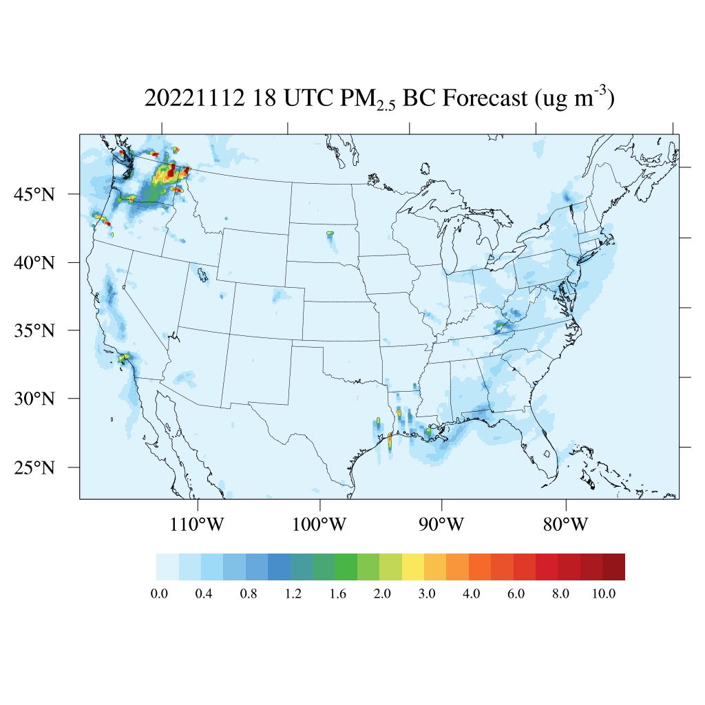
HAQES 3-Hourly Ensemble mean surface PM2.5 Black Carbon concentration, North America V1 (HAQES_NA_PM25_BC) at GES DISC
National Aeronautics and Space Administration —
This product provides HAQES 3-hourly ensemble mean surface PM2.5 Black Carbon concentration over the continental United States (CONUS) and surrounding regions. The... -
Federal
GIS shapefiles for the June 27th lava flow at Kīlauea volcano, Hawaiʻi, June 2014–June 2016
Department of the Interior —
This dataset contains shapefiles and associated metadata showing evolution of the "June 27th" lava flow (Puʻu ʻŌʻō eruptive episode 61e) that was active at Kīlauea... -
State
Geologic Database of Information on Volcanoes in Alaska (GeoDIVA)
State of Alaska —
Geologic Database of Information on Volcanoes in Alaska (GeoDIVA), Digital Data Series 20, is the enterprize database that serves as the back-end to AVO's public and... -
Federal
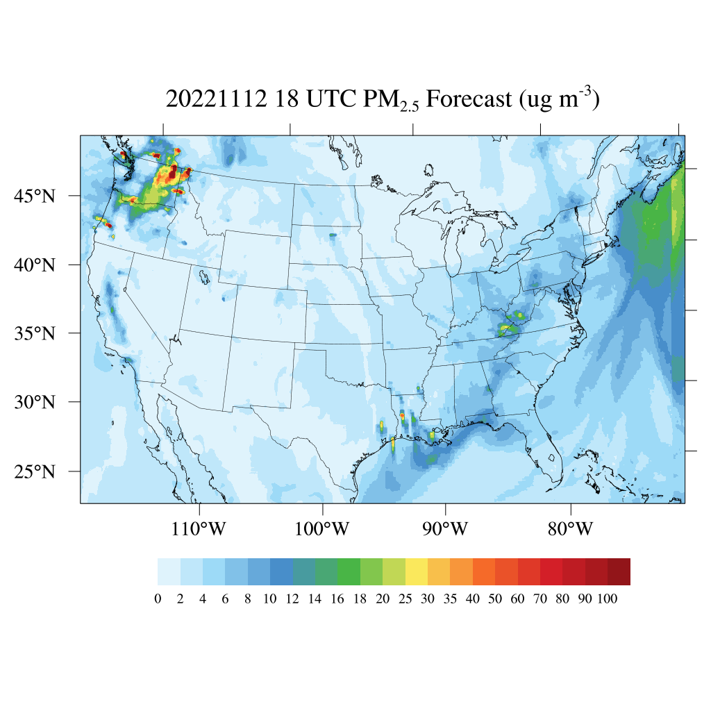
HAQES 3-Hourly Ensemble mean surface total PM2.5 concentration, North America V1 (HAQES_NA_PM25_TOT) at GES DISC
National Aeronautics and Space Administration —
This product provides HAQES 3-hourly ensemble mean surface total PM2.5 concentration over the continental United States (CONUS) and surrounding regions. The data is... -
Federal
Wind rose plots for the volcano: 221300 Chiracha
Department of the Interior —
This zip folder contains ASCII text files of vectors at the specified volcano at 12-hour intervals, from January 1, 1990 through December 28, 2009. The wind vectors... -
Federal
Wind rose plots for the volcano: 311370 Isanotski
Department of the Interior —
This zip folder contains ASCII text files of vectors at the specified volcano at 12-hour intervals, from January 1, 1990 through December 28, 2009. The wind vectors... -
Federal
OMI/Aura Sulphur Dioxide (SO2) Total Column 1-orbit L2 Swath 13x24 km V003 NRT
National Aeronautics and Space Administration —
The Ozone Monitoring Instrument (OMI) was launched aboard the EOS-Aura satellite on July 15, 2004 (1:38 pm equator crossing time, ascending mode). OMI with its 2600... -
Federal
Mirador - Earth Surface and Interior
National Aeronautics and Space Administration —
Earth Science data access made simple. The goal of the Earth Surface and Interior focus area is to assess, mitigate and forecast the natural hazards that affect... -
Federal
Wind rose plots for the volcano: 357150 Puyehue-Cordon Caulle
Department of the Interior —
This zip folder contains ASCII text files of vectors at the specified volcano at 12-hour intervals, from January 1, 1990 through December 28, 2009. The wind vectors... -
Federal
Wind rose plots for the volcano: 233011 Ambre-Bobaomby
Department of the Interior —
This zip folder contains ASCII text files of vectors at the specified volcano at 12-hour intervals, from January 1, 1990 through December 28, 2009. The wind vectors... -
Federal
Wind rose plots for the volcano: 351002 Escondido, El
Department of the Interior —
This zip folder contains ASCII text files of vectors at the specified volcano at 12-hour intervals, from January 1, 1990 through December 28, 2009. The wind vectors... -
Federal
Wind rose plots for the volcano: 211070 Campi Flegrei Mar Sicilia
Department of the Interior —
This zip folder contains ASCII text files of vectors at the specified volcano at 12-hour intervals, from January 1, 1990 through December 28, 2009. The wind vectors... -
Federal
Wind rose plots for the volcano: 360010 Saba
Department of the Interior —
This zip folder contains ASCII text files of vectors at the specified volcano at 12-hour intervals, from January 1, 1990 through December 28, 2009. The wind vectors...
1,834 datasets found for "Volcanic Eruptions"