
-
Federal
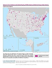
ATSDR Hazardous Waste Site Polygon Data, Version 2 recent views
National Aeronautics and Space Administration —
The Agency for Toxic Substances and Disease Registry (ATSDR) Hazardous Waste Site Polygon Data, Version 2 consists of 2,080 polygons for selected hazardous waste... -
Federal
CYGNSS Level 3 MRG Science Data Record Version 3.2.1 recent views
National Aeronautics and Space Administration —
This dataset contains the version 3.2.1 CYGNSS level 3 science data record merged storm (MRG) wind speed which combines CYGNSS storm-centric gridded (SCG) wind... -
Federal
UNH TDP - Concurrent Measurements of Inflow, Power Performance, and Loads for a Grid-Synchronized Vertical Axis Cross-Flow Turbine Operating in a Tidal Estuary recent views
Department of Energy —
This data was collected between October 12 and December 15 of 2021 at the University of New Hampshire (UNH) and Atlantic Marine Energy Center (AMEC) turbine... -
Federal
JPL GRACE and GRACE-FO Mascon Ocean, Ice, and Hydrology Equivalent Water Height Coastal Resolution Improvement (CRI) Filtered Release 06.1 Version 03 recent views
National Aeronautics and Space Administration —
This dataset contains gridded monthly global water storage/height anomalies relative to a time-mean, derived from GRACE and GRACE-FO and processed at JPL using the... -
Federal
F00436: NOS Hydrographic Survey , Approaches to Brunswick, Georgia, 1997-11-17 recent views
National Oceanic and Atmospheric Administration, Department of Commerce —
The National Oceanic and Atmospheric Administration (NOAA) has the statutory mandate to collect hydrographic data in support of nautical chart compilation for safe... -
Federal
Aquarius Official Release Level 3 Sea Surface Density Standard Mapped Image Descending Daily Data V5.0 recent views
National Aeronautics and Space Administration —
Aquarius Level 3 sea surface density standard mapped image data contains gridded 1 degree spatial resolution density data averaged over daily, 7 day, monthly, and... -
Federal
MODIS Aqua Level 3 SST Thermal IR Monthly 4km Daytime V2019.0 NGDA recent views
National Aeronautics and Space Administration —
Day and night spatially gridded (L3) global NASA skin sea surface temperature (SST) products from the Moderate-resolution Imaging Spectroradiometer (MODIS) onboard... -
Federal
Aquarius Official Release Level 3 Rain-flagged Sea Surface Salinity Standard Mapped Image Seasonal Data V5.0 recent views
National Aeronautics and Space Administration —
Aquarius Level 3 sea surface salinity (SSS) rain-flagged standard mapped image data contains gridded 1 degree spatial resolution SSS averaged over daily, 7 day,... -
Federal
Ecomapper data for the SPURS-1 N. Atlantic field campaign recent views
National Aeronautics and Space Administration —
The SPURS (Salinity Processes in the Upper Ocean Regional Study) project is an oceanographic process study and associated field program that aim to elucidate key... -
Federal
GHRSST Level 4 MUR Global Foundation Sea Surface Temperature Analysis (v4.1) NGDA recent views
National Aeronautics and Space Administration —
A Group for High Resolution Sea Surface Temperature (GHRSST) Level 4 sea surface temperature analysis produced as a retrospective dataset (four day latency) and near-... -
Federal
Perdido Host - Alaminos Canyon 857 recent views
National Oceanic and Atmospheric Administration, Department of Commerce —
GCOOS 52North Sensor Observation Service This station provides the following variables: Air pressure, Air temperature, Dew point temperature, Direction of sea water... -
Federal
Poverty Mapping Project: Small Area Estimates of Poverty and Inequality recent views
National Aeronautics and Space Administration —
The Poverty Mapping Project: Small Area Estimates of Poverty and Inequality data set consists of consumption-based poverty, inequality and related measures for... -
Federal
JPL SMAP Level 2B Near Real-time (2Hr Latency) CAP Sea Surface Salinity V5.0 Validated Dataset recent views
National Aeronautics and Space Administration —
This is the PI-produced JPL SMAP-SSS V5.0, level 2B NRT CAP, validated sea surface salinity (SSS) and extreme winds orbital/swath product from the NASA Soil Moisture... -
Federal
Classification of Global Forests for IPCC Aboveground Biomass Tier 1 Estimates, 2020 recent views
National Aeronautics and Space Administration —
This dataset provides classes of global forests delineated by status/condition in 2020 at approximately 30-m resolution. The data support generating Tier 1 estimates... -
Federal
Sentinel-6A MF Jason-CS L1B P4 Altimeter Low Resolution (LR) NTC Geolocated Waveforms F08 recent views
National Aeronautics and Space Administration —
Provides reprocessed L1B low resolution (LR) non-time critical (NTC; 60-day latency) altimetry data from the Poseidon-4 SAR altimeter on the Sentinel-6A Michael... -
Federal
Sentinel-6A MF Jason-CS L2 P4 Altimeter Low Resolution (LR) NTC Ocean Surface Topography F08 recent views
National Aeronautics and Space Administration —
Provides low resolution (LR) non-time critical (NTC; 60-day latency) measurements of sea surface height anomaly (SSHA), Significant Wave Height (SWH), and Wind Speed,... -
Federal
Newberry EGS Demonstration: Well 55-29 Stimulation Data 2014 recent views
Department of Energy —
The Newberry Volcano EGS Demonstration in central Oregon, a 5 year project begun in 2010, tests recent technological advances designed to reduce the cost of power... -
Federal
Gridded Population of the World, Version 3 (GPWv3): Population Density Grid, Future Estimates recent views
National Aeronautics and Space Administration —
The Gridded Population of the World, Version 3 (GPWv3): Population Density Grid, Future EstimatesFuture Estimates consists of estimates of human population for the... -
Federal
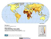
Poverty Mapping Project: Global Subnational Infant Mortality Rates recent views
National Aeronautics and Space Administration —
The Poverty Mapping Project: Global Subnational Infant Mortality Rates data set consists of estimates of infant mortality rates for the year 2000. The infant... -
Federal
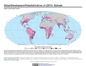
Global Development Potential Indices recent views
National Aeronautics and Space Administration —
The Global Development Potential Indices (DPIs) data set contains thirteen sector-level DPIs for sectors related to renewable energy (concentrated solar power,...

Official websites use .gov
A
.gov website belongs to an official government
organization in the United States.
Secure .gov websites use HTTPS
A
lock (
) or https:// means you’ve safely connected to
the .gov website. Share sensitive information only on official,
secure websites.
.jpg)