
-
Federal
Stock assessment model outputs for ICCAT (International) managed species
National Oceanic and Atmospheric Administration, Department of Commerce —
Includes outputs from the various models run in the evaluation of stock status for species managed by the International Commission for the Conservation of Atlantic Tuna. -
Federal
Benthic Cover Derived from Analysis of Benthic Images Collected from the NOAA R/V Manta in the Flower Garden Banks National Marine Sanctuary from 2022-08-25 to 2022-09-02 (NCEI Accession 0290327)
National Oceanic and Atmospheric Administration, Department of Commerce —
Transects were run alongside NCRMPâs LPI transects at grid-based stratified random sites on the EFGB and WFGB coral caps. The transect sites were chosen by NCRMP... -
Federal
East Florida 2020 ESI INVERT Polygons, Lines
National Oceanic and Atmospheric Administration, Department of Commerce —
This data set contains sensitive biological resource data for seagrass, coral reef, hard-bottom communities, and deep-sea coral for East Florida. Vector polygons in... -
Federal
Georgia 2015 ESI PARKS-MANAGED AREAS Polygons, Points
National Oceanic and Atmospheric Administration, Department of Commerce —
This data set contains vector polygons depicting boundaries for management areas, marine sanctuaries, military areas, National Estuarine Research Reserves (NERRs),... -
Federal
NPP Grassland: Bridger, USA, 1970-1973, R1
National Aeronautics and Space Administration —
This data set contains three ASCII text files for the Bridger grassland study site in the Rocky Mountains (45.78 N, -110.78 W, Elevation 2,340 m). Two files contain... -
Federal
Alaska's Changing YK Delta: Knowledge Exchange between Elders and Geoscientists, 2018
National Aeronautics and Space Administration —
This dataset provides a booklet documenting the discussions and outcomes from a knowledge-exchange meeting with Yup'ik elders from the Yukon-Kuskokwim Delta (YKD),... -
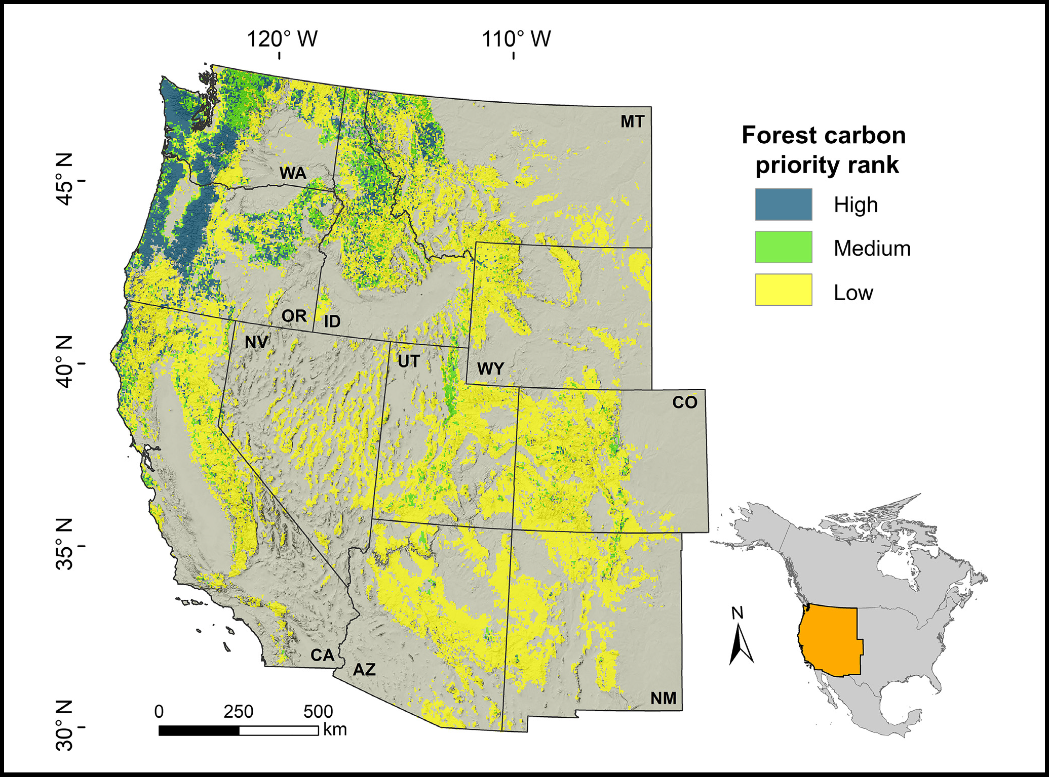
Federal
Forest Preservation Ranking and Vertebrate Species Richness, Western USA, 2020-2099
National Aeronautics and Space Administration —
This dataset provides related gridded outputs of future modeled forest carbon sequestration priority and related species richness and habitat suitability for the... -
Federal
National Coral Reef Monitoring Program: Towed-diver Surveys of Benthic Habitat, Key Benthic Species, and Marine Debris Sightings of American Samoa in 2015
National Oceanic and Atmospheric Administration, Department of Commerce —
The towed-diver method is used to conduct benthic surveys, assessing large-scale disturbances (e.g., bleaching) and quantifying benthic components such as habitat... -
Federal
GL_St_Marys_River_2021 ESI PARKS/MANAGED AREAS Polygons
National Oceanic and Atmospheric Administration, Department of Commerce —
This feature class resides within the SOCECON Feature Data Set of the Great Lakes St. Marys River 2021 ESI Geodatabase. It contains vector polygons representing... -
Federal
Sensitivity of Coastal Environments and Wildlife to Spilled Oil: Upper Coast of Texas: MGT (Management Area Polygons)
National Oceanic and Atmospheric Administration, Department of Commerce —
This data set contains sensitive human-use data for aquaculture sites, Designated Critical Habitats, management areas, Nature Conservancy properties, parks, and... -
Federal
East Florida 2020 ESI RESOURCE MANAGEMENT Polygons, Points
National Oceanic and Atmospheric Administration, Department of Commerce —
This data set contains sensitive biological resource data for seagrass, coral reef, hard-bottom communities, and deep-sea coral for East Florida. Vector polygons in... -
Federal
North Carolina 2016 ESI PARKS/MANAGED AREAS Polygons, Points
National Oceanic and Atmospheric Administration, Department of Commerce —
This data set contains vector polygons depicting locations for wildlife refuges, military areas, State Protected Areas, parks (regional or State), National Parks,...

Official websites use .gov
A
.gov website belongs to an official government
organization in the United States.
Secure .gov websites use HTTPS
A
lock (
) or https:// means you’ve safely connected to
the .gov website. Share sensitive information only on official,
secure websites.