
-
State
Soil index properties and radiocarbon ages of the Haines-Takshanuk Mountains-Chilkat Peninsula area statemap project, Southeast Alaska
State of Alaska —
Soil index properties and radiocarbon ages of the Haines-Takshanuk Mountains-Chilkat Peninsula area statemap project, Southeast Alaska, Raw Data File 2024-27,... -
Federal
Alaska Steller Sea Lion Non-pup Count Database
National Oceanic and Atmospheric Administration, Department of Commerce —
This database contains counts of adult and juvenile (non-pup) Steller sea lions on rookeries and haulouts in Alaska made between 1904 and 2019. Non-pup counts have... -
State
Tsunami inundation maps of Sitka, Alaska
State of Alaska —
The purpose of this study is to evaluate potential tsunami hazards for the community of Sitka. We numerically modeled the extent of inundation from tsunami waves... -
Federal
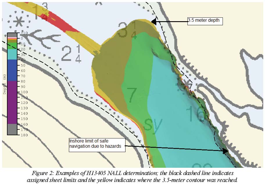
H13405: NOS Hydrographic Survey , 2020-09-13
National Oceanic and Atmospheric Administration, Department of Commerce —
The National Oceanic and Atmospheric Administration (NOAA) has the statutory mandate to collect hydrographic data in support of nautical chart compilation for safe... -
Federal
H13774: NOS Hydrographic Survey , 2023-10-15
National Oceanic and Atmospheric Administration, Department of Commerce —
The National Oceanic and Atmospheric Administration (NOAA) has the statutory mandate to collect hydrographic data in support of nautical chart compilation for safe... -
Federal
Elfin Cove, Alaska Tsunami Forecast Grids for MOST Model
National Oceanic and Atmospheric Administration, Department of Commerce —
The Elfin Cove, Alaska Forecast Grids provides bathymetric data strictly for tsunami inundation modeling with the Method of Splitting Tsunami (MOST) model. MOST is a... -
Federal
AFSC/ABL: Coldwater coral growth
National Oceanic and Atmospheric Administration, Department of Commerce —
Colonies of the gorgonian coral Calcigorgia spiculifera were tagged at three sites in Southeast Alaska, Little Port Walter, Tenakee Inlet, and Kelp Bay. The corals... -
Federal
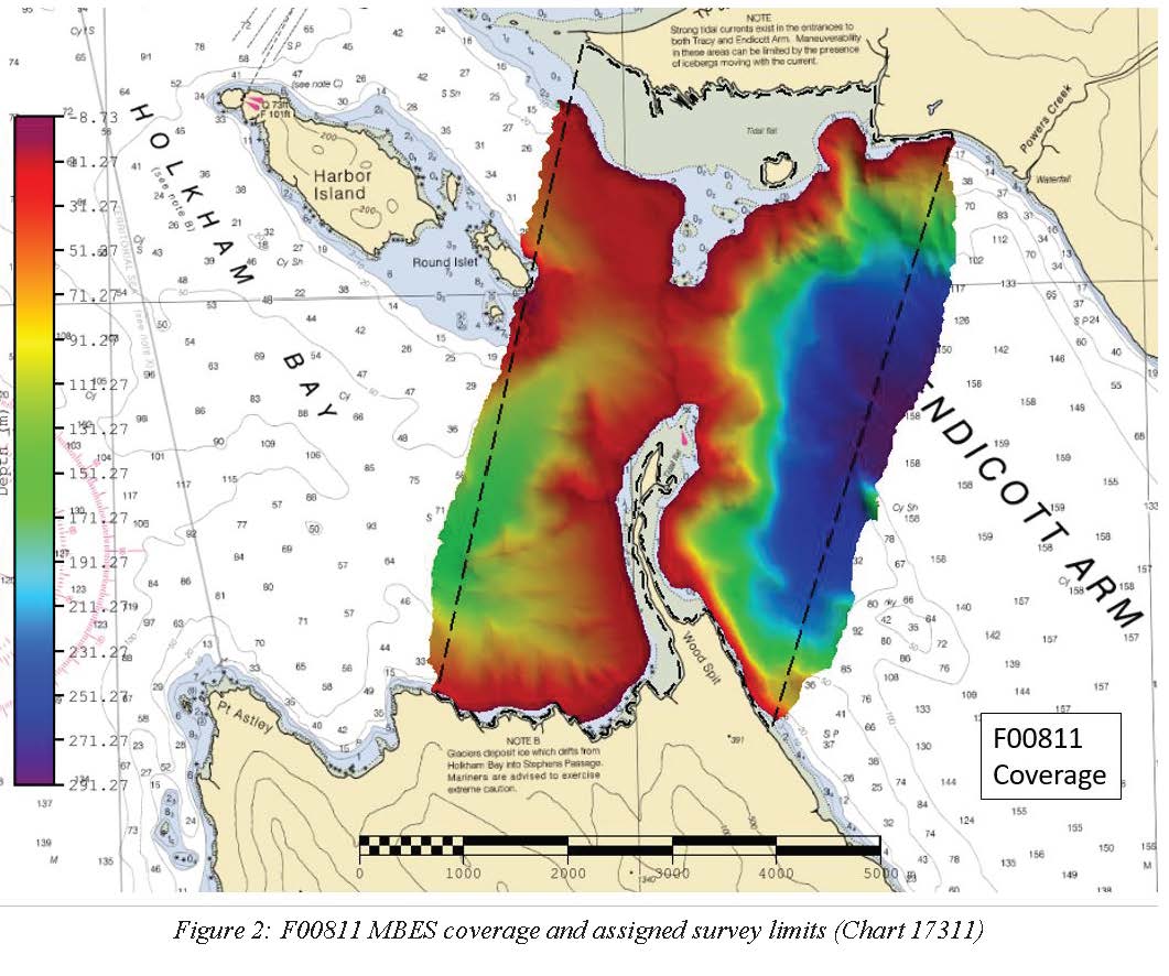
F00811: NOS Hydrographic Survey , 2020-10-10
National Oceanic and Atmospheric Administration, Department of Commerce —
The National Oceanic and Atmospheric Administration (NOAA) has the statutory mandate to collect hydrographic data in support of nautical chart compilation for safe... -
Federal
AFSC/ABL: Female Giant Grenadier maturity
National Oceanic and Atmospheric Administration, Department of Commerce —
Giant grenadiers Albatrossia pectoralis are caught as bycatch in deep-sea commercial fisheries in relatively large numbers. The population appears to be stable,... -
State
Photogrammetric data of the Haines Highway corridor: May 26, 2014
State of Alaska —
The State of Alaska Division of Geological & Geophysical Surveys (DGGS) produced an orthorectified aerial optical image mosaic (orthoimage) and digital surface... -
Federal
AFSC/ABL: NPRB project 1106 Improved aging estimates for spiny dogfish
National Oceanic and Atmospheric Administration, Department of Commerce —
The spiny dogfish (Squalus suckleyi, formerly Squalus acanthias, Ebert et al. 2010) is a small, long-lived and slow-growing shark, which is vulnerable to overfishing.... -
State
Regional tsunami hazard assessment for the communities of Port Alexander, Craig, and Ketchikan, Southeast Alaska
State of Alaska —
We assess potential tsunami hazards for coastal communities in Southeast Alaska: Port Alexander, Craig, Saxon, Mountain Point, and Ketchikan. The primary tsunami... -
Federal
Southeast Alaska ESI: MGT (Management Area Polygons)
National Oceanic and Atmospheric Administration, Department of Commerce —
This data set contains management area data for National Parks, Wildlife Refuges, and areas designated as Critical Habitat in Southeast Alaska. Vector polygons in... -
State
Regional tsunami hazard assessment for the communities of Kasaan, Klawock, Metlakatla, Pelican, Point Baker, and Port Protection in Southeast Alaska
State of Alaska —
We assess potential tsunami hazards for six communities in Southeast Alaska: Kasaan, Klawock, Metlakatla, Pelican, Point Baker, and Port Protection. These communities... -
Federal
Southeast Alaska ESI: BIOINDEX (Biological Index Polygons)
National Oceanic and Atmospheric Administration, Department of Commerce —
This data set contains vector polygons representing the boundaries of the 1:300,000 map boundaries used in the creation of the Environmental Sensitivity Index (ESI)... -
State
Lidar-derived elevation data for Eaglecrest ski area, Southeast Alaska, collected September 6, 2019
State of Alaska —
The Alaska Division of Geological & Geophysical Surveys (DGGS) used aerial lidar to produce a classified point cloud, digital surface model (DSM), digital terrain... -
Federal
Charter Halibut Limited Access Program
National Oceanic and Atmospheric Administration, Department of Commerce —
This limited access system limits the number of charter vessels that may participate in the guided sport fishery for halibut in area 2C and 3A. NMFS issues a charter... -
State
High-resolution lidar data for the Chilkat Ridge area, Alaska
State of Alaska —
The State of Alaska Division of Geological & Geophysical Surveys (DGGS) used lidar to produce a digital terrain model (DTM) and digital surface model (DSM) over... -
Federal
AFSC/ABL: Rockfish Barotrauma
National Oceanic and Atmospheric Administration, Department of Commerce —
Because rockfish (Sebastes spp.) are physoclystic, i.e. their gas bladders are closed off from the gut, they often suffer internal injuries from rapid, internal air...

Official websites use .gov
A
.gov website belongs to an official government
organization in the United States.
Secure .gov websites use HTTPS
A
lock (
) or https:// means you’ve safely connected to
the .gov website. Share sensitive information only on official,
secure websites.