
-
Federal
AFSC/REFM: Pacific cod Localized Depletion Study
National Oceanic and Atmospheric Administration, Department of Commerce —
Data from Localized Depletion study for Pacific cod 2001-2005. Study was conducted using cod pot gear to measure localized abundance of Pacific cod inside and outside... -
Federal
VEMAP 1: Georeferencing
National Aeronautics and Space Administration —
The Vegetation/Ecosystem Modeling and Analysis Project (VEMAP) is an ongoing multiinstitutional, international effort addressing the response of biogeography and... -
Federal
BOREAS SERM Forest Cover Data Layers of the SSA in Vector Format
National Aeronautics and Space Administration —
The forest cover data provided by Saskatchewan Environment and Resource Management, Forestry Branch - Inventory Unit (SERM-FBIU) are basically a digital version of... -
Federal
ABoVE: Lake Growing Season Green Surface Reflectance Trends, AK and Canada, 1984-2019
National Aeronautics and Space Administration —
This dataset provides an annual time series of Landsat green surface reflectance and the derived annual trend during the growing season (June and July) for 472,890... -
Federal
CARVE: Alaskan Fire Emissions Database (AKFED), 2001-2013
National Aeronautics and Space Administration —
This data set provides estimates of annual carbon emissions (kg carbon per square meter) from boreal fires at 450-m resolution for the state of Alaska between 2001... -
Federal
LBA Regional Organic Soil Carbon and Nitrogen Data (Zinke et al.)
National Aeronautics and Space Administration —
The data set contains a subset of a global organic soil carbon and nitrogen data set (Zinke et al. 1986). The subset was created for the study area of the Large Scale... -
Federal
LBA Regional Derived Soil Properties, 0.5-Deg (ISRIC-WISE)
National Aeronautics and Space Administration —
The data set consists of a subset of the ISRIC-WISE global data set of derived soil properties for the study area of the Large Scale Biosphere-Atmosphere Experiment... -
State
2010 Urban Water Management Plan (UWMP) Data
State of California —
Numeric data gleaned from the 2010 UWMP reports as reported in the DOST database. -
Federal
LBA Regional River Discharge Data (Coe and Olejniczak)
National Aeronautics and Space Administration —
This data set is a subset of a global river discharge data set by Coe and Olejniczak (1999). The subset was created for the study area of the Large Scale Biosphere-... -
Federal
Geoecology: County-Level Environmental Data for the United States, 1941-1981
National Aeronautics and Space Administration —
The Geoecology database is a compilation of environmental data for the period 1941 to 1981. The Geoecology database contains selected data on terrain and soils, water... -
Federal
LBA-ECO LC-09 Natural, Infrastructure, and Boundary Features, Amazonian Sites, Brazil
National Aeronautics and Space Administration —
This data set includes 16 zipped archives of shapefiles of cities, rivers and streams, roads, and study area boundaries of several Amazonian study sites: Altamira,... -
Federal
A Global Database of Litterfall Mass and Litter Pool Carbon and Nutrients
National Aeronautics and Space Administration —
Measurement data of aboveground litterfall and littermass and litter carbon, nitrogen, and nutrient concentrations were extracted from 685 original literature sources... -
Federal
LBA-ECO LC-01 Landsat TM Land Use/Land Cover, Northern Ecuadorian Amazon: 1986-1999
National Aeronautics and Space Administration —
This data set contains Landsat TM imagery for the years 1986, 1989, 1996, and 1999, that have been classified into four land use/land cover (LULC) classes: Forest,... -
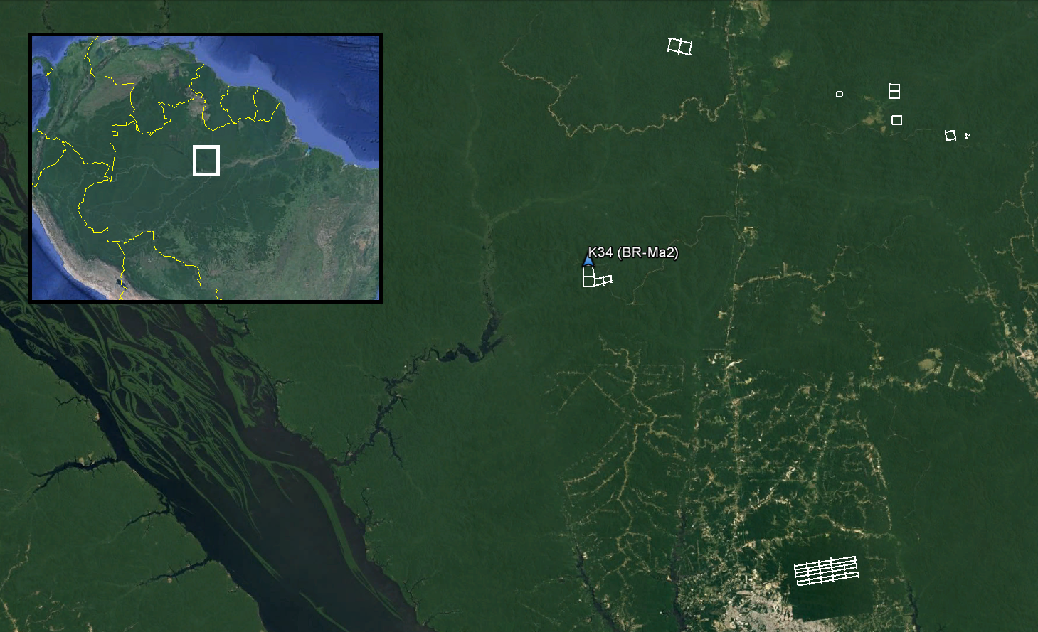
Federal
LiDAR and DTM Data from Forested Land Near Manaus, Amazonas, Brazil, 2008
National Aeronautics and Space Administration —
This data set provides LiDAR point clouds and digital terrain models (DTM) from surveys over the K34 tower site in the Cuieiras Biological Reserve, over forest... -
Federal
LBA Regional Wetlands Data Set, 1-Degree (Matthews and Fung)
National Aeronautics and Space Administration —
This database, compiled by Matthews and Fung (1987), provides information on the distribution and environmental characteristics of natural wetlands. The database was... -
Federal
Project HOTSPOT: Mountain Home Well Borehole Geophysics Database
Department of Energy —
The Snake River Plain (SRP), Idaho, hosts potential geothermal resources due to elevated groundwater temperatures associated with the thermal anomaly Yellowstone-... -
Federal
Global Land Cover Mapping and Estimation Yearly 30 m V001
National Aeronautics and Space Administration —
NASA's Making Earth System Data Records for Use in Research Environments (MEaSUREs) Global Land Cover Mapping and Estimation (GLanCE) annual 30 meter (m) Version 1... -
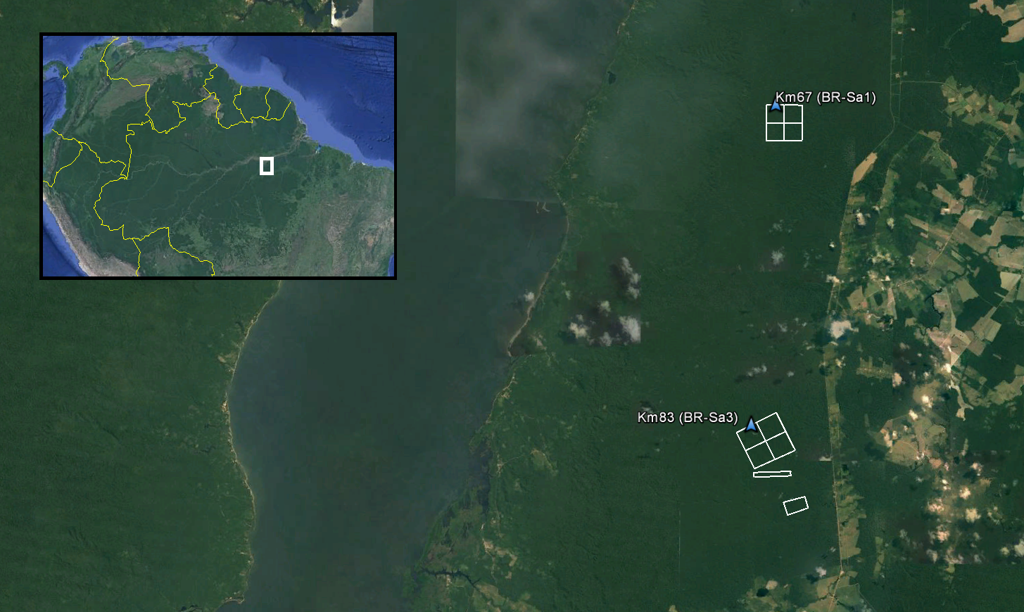
Federal
LiDAR and DTM Data from Tapajos National Forest in Para, Brazil, 2008
National Aeronautics and Space Administration —
This data set provides LiDAR point clouds and digital terrain models (DTM) from surveys over the Tapajos National Forest in Belterra municipality, Para, Brazil during... -
Federal
United States Offshore Wind Supply Curves 2024
Department of Energy —
This data packet contains supply curves, hourly generation profiles, and composite siting exclusion TIFFs for offshore wind (OSW) in the waters of the EEZ off the...

Official websites use .gov
A
.gov website belongs to an official government
organization in the United States.
Secure .gov websites use HTTPS
A
lock (
) or https:// means you’ve safely connected to
the .gov website. Share sensitive information only on official,
secure websites.