
-
Federal
OSCAR third degree resolution ocean surface currents - yearly files recent views
National Aeronautics and Space Administration —
OSCAR (Ocean Surface Current Analysis Real-time) contains near-surface ocean current estimates, derived using quasi-linear and steady flow momentum equations. The... -
Federal
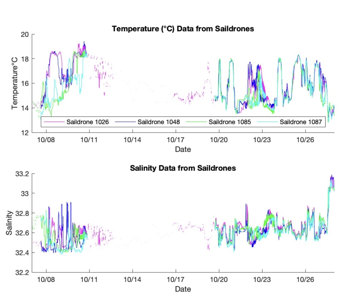
S-MODE L2 Temperature and Salinity from Saildrones Version 1 recent views
National Aeronautics and Space Administration —
This dataset contains Saildrone in-situ measurements taken during the Sub-Mesoscale Ocean Dynamics Experiment (S-MODE) conducted approximately 300 km offshore of San... -
Federal
SWOT Level 2 KaRIn Low Rate Sea Surface Height Data Product - Basic, Version 2.0 recent views
National Aeronautics and Space Administration —
The SWOT Level 2 KaRIn Low Rate Sea Surface Height Basic Data Product from the Surface Water Ocean Topography (SWOT) mission provides global sea surface height and... -
Federal
GRACE-FO Level-2 Monthly Geopotential Spherical Harmonics JPL Release 6.3 (RL06.3) recent views
National Aeronautics and Space Administration —
FOR EXPERT USE ONLY. This dataset contains estimates of the total month-by-month geopotential of the Earth, derived from the Gravity Recovery and Climate Experiment... -
Federal
JPL TELLUS GRACE-FO Level-3 Monthly Ocean Bottom Pressure Anomaly Release 6.3 version 04 recent views
National Aeronautics and Space Administration —
This data set is produced by the Jet Propulsion Laboratory (JPL) as part of the GRACE-FO (Gravity Recovery and Climate Experiment Follow-On) program and derives the... -
Federal
OMG Narwhals Shipboard Conductivity, Temperature, and Depth (CTD) profiles, 2018-2020 recent views
National Aeronautics and Space Administration —
This OMG Narwhals dataset contains measurements from the ship based full water column CTD profiles that were obtained during summer mooring deployment/recovery... -
Federal
MetOp-A ASCAT Scatterometer Inter-Calibrated ESDR Level 2 Ocean Surface Equivalent Neutral Wind Vectors and Wind Stress Vectors Version 1.1 recent views
National Aeronautics and Space Administration —
This dataset contains ocean surface wind vectors (equivalent neutral and true 10m) and wind stress vectors derived from satellite-based scatterometer observations... -
Federal
MODIS Terra Level 3 SST MID-IR Daily 9km Nighttime V2019.0 NGDA recent views
National Aeronautics and Space Administration —
Day and night spatially gridded (L3) global NASA skin sea surface temperature (SST) products from the Moderate-resolution Imaging Spectroradiometer (MODIS) onboard... -
Federal
CYGNSS Level 2 Ocean Surface Heat Flux Climate Data Record Version 1.1 recent views
National Aeronautics and Space Administration —
This dataset contains the first release, Version 1.1, of the CYGNSS Level 2 Ocean Surface Heat Flux Climate Data Record (CDR), which provides the time-tagged and... -
Federal
CYGNSS Level 1 Calibrated Raw IF Version 1.0 recent views
National Aeronautics and Space Administration —
This dataset contains the first release, Version 1.0, of the CYGNSS Calibrated Raw Intermediate Frequency (IF) based L1 Product. This product includes several... -
Federal
Aquarius Official Release Level 3 Sea Surface Salinity Standard Mapped Image Seasonal Data V5.0 recent views
National Aeronautics and Space Administration —
Aquarius Level 3 sea surface salinity (SSS) standard mapped image data contains gridded 1 degree spatial resolution SSS averaged over daily, 7 day, monthly, and... -
Federal
GHRSST NOAA/STAR Metop-C AVHRR FRAC ACSPO v2.80 0.02 L3U Dataset (GDS v2) recent views
National Aeronautics and Space Administration —
This L3U (Level 3 Uncollated) dataset contains global daily Sea Surface Temperature (SST) on a 0.02 degree grid resolution. It is produced by the National Oceanic and... -
Federal
MODIS Aqua Level 3 SST MID-IR Daily 4km Nighttime V2019.0 NGDA recent views
National Aeronautics and Space Administration —
Day and night spatially gridded (L3) global NASA skin sea surface temperature (SST) products from the Moderate-resolution Imaging Spectroradiometer (MODIS) onboard... -
Federal
MODIS Aqua Level 3 SST MID-IR Monthly 4km Nighttime V2019.0 NGDA recent views
National Aeronautics and Space Administration —
Day and night spatially gridded (L3) global NASA skin sea surface temperature (SST) products from the Moderate-resolution Imaging Spectroradiometer (MODIS) onboard... -
Federal
GHRSST Level 2P Global Subskin Sea Surface Temperature from the Advanced Scanning Microwave Radiometer - Earth Observing System (AMSR-E) on the NASA Aqua Satellite recent views
National Aeronautics and Space Administration —
The Advanced Microwave Scanning Radiometer (AMSR-E) was launched on 4 May 2002, aboard NASA's Aqua spacecraft. The National Space Development Agency of Japan (NASDA)... -
Federal
GHRSST NOAA/STAR GOES-16 ABI L3C America Region SST v2.70 dataset in GDS2 recent views
National Aeronautics and Space Administration —
The ACSPO G16/ABI L3C (Level 3 Collated) product is a gridded version of the ACSPO G16/ABI L2P product available at... -
Federal
GHRSST Level 3U Global Near-Real-Time Subskin Sea Surface Temperature version 8a from the Advanced Microwave Scanning Radiometer 2 on the GCOM-W satellite recent views
National Aeronautics and Space Administration —
GDS2 Version -The Advanced Microwave Scanning Radiometer 2 (AMSR2) was launched on 18 May 2012, onboard the Golbal Change Observation Mission - Water (GCOM-W)... -
Federal
ECCO Sea-Ice and Snow Concentration and Thickness - Daily Mean 0.5 Degree (Version 4 Release 4) recent views
National Aeronautics and Space Administration —
This dataset contains daily-averaged sea-ice and snow concentration and thickness interpolated to a regular 0.5-degree grid from the ECCO Version 4 revision 4 (V4r4)... -
Federal
ECCO Sea-Ice and Snow Concentration and Thickness - Monthly Mean llc90 Grid (Version 4 Release 4) recent views
National Aeronautics and Space Administration —
This dataset provides monthly-averaged sea-ice and snow concentration, thickness, and pressure loading on the native Lat-Lon-Cap 90 (LLC90) model grid from the ECCO... -
Federal
MODIS Aqua Level 3 SST Thermal IR Annual 4km Nighttime V2019.0 NGDA recent views
National Aeronautics and Space Administration —
Day and night spatially gridded (L3) global NASA skin sea surface temperature (SST) products from the Moderate-resolution Imaging Spectroradiometer (MODIS) onboard...

Official websites use .gov
A
.gov website belongs to an official government
organization in the United States.
Secure .gov websites use HTTPS
A
lock (
) or https:// means you’ve safely connected to
the .gov website. Share sensitive information only on official,
secure websites.