
-
Federal
GHRSST Level 2P Global skin Sea Surface Temperature from the Infrared Atmospheric Sounding Interferometer (IASI) on the Metop-B satellite (GDS V2) produced by OSI SAF
National Aeronautics and Space Administration —
A Group for High Resolution Sea Surface Temperature (GHRSST) Level 2P dataset based on multi-channel sea surface temperature (SST) retrievals generated in real-time... -
Federal
CAR Clams Chesapeake Lighthouse Aircraft Ocean Measurements L1 V1 (CAR_CLAMS_L1C) at GES DISC
National Aeronautics and Space Administration —
CLAMS is the Chesapeake Lighthouse and Aircraft Measurements for Satellites field campaign sponsored by CERES, MISR, MODIS-Atmospheres and the NASA/GEWEX Global... -
Federal
OMI/Aura Aerosol product Multi-wavelength Algorithm Zoomed 1-Orbit L2 Swath 13x12km V003 (OMAEROZ) at GES DISC
National Aeronautics and Space Administration —
The reprocessed OMI/Aura Level-2 Zoomed Aerosol data product OMAEROZ at 13x12 km resolution have been made available from the NASA Goddard Earth Sciences Data and... -
Federal
OMG Glacial Elevations from GLISTIN-A Ver. 1
National Aeronautics and Space Administration —
This dataset contains 50m horizontal resolution gridded digital elevation models (DEMs) of Greenland Ice Sheet outlet glaciers collected during the NASA Oceans... -
Federal
Delta-X: Delft3D Sediment Model, Site 294, Terrebonne Basin, MRD, Louisiana, USA
National Aeronautics and Space Administration —
This dataset contains the Delft3D model of the intensive site 294 in the Terrebonne Basin along the Mississippi River Delta (MRD) in coastal Louisiana. Simulations... -
Federal
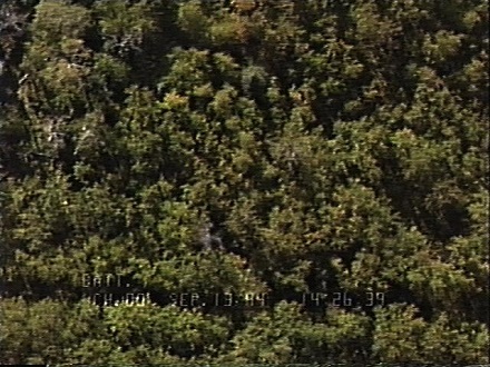
BOREAS RSS-03 Imagery and Snapshots from a Helicopter-Mounted Video Camera
National Aeronautics and Space Administration —
This data set provides images of boreal forests in central Canada collected over numerous tower and auxiliary sites during the BOREAS Intensive Field Campaigns (IFCs)... -
Federal
ABoVE: Post-Fire and Unburned Vegetation Community and Field Data, NWT, Canada, 2019
National Aeronautics and Space Administration —
This dataset provides vegetation community characteristics, soil moisture, and biophysical data collected in 2019 from 11 study areas, which contained 28 sites that... -
Federal
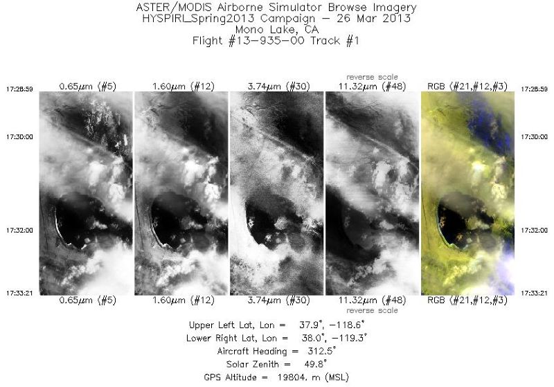
MASTER: HyspIRI Airborne Campaign, California, Early Spring 2013, V2
National Aeronautics and Space Administration —
This dataset includes Level 1B (L1B) and Level 2 (L2) data products from the MODIS/ASTER Airborne Simulator (MASTER) instrument. The spectral data were collected as... -
Federal
RSS CCMP Monthly 10 Meter Surface Winds Level 4 Version 3.1
National Aeronautics and Space Administration —
This data set contains a monthly-mean, 0.25 degree resolution, near-global gridded analysis of ocean surface winds (wind speed, components, and anomalies) from the... -
Federal
Joint Global Ocean Flux Study (JGOFS) Arabian Sea measurements - Biogeochemical Ocean Flux Study (BOFS)
National Aeronautics and Space Administration —
Joint Global Ocean Flux Study (JGOFS) measurements taken by Germany, The Netherlands, and the United Kingdom from 1991. -
Federal
ATTREX Global Hawk UAS Meteorological and Navigational Measurements
National Aeronautics and Space Administration —
ATTREX-Aircraft_navigational_meteorological_Measurements are in-situ navigational and meteorological measurements collected onboard the Global Hawk Uninhabited Aerial... -
Federal
AVIRIS-Classic: L2 Calibrated Reflectance, Facility Instrument Collection, V1
National Aeronautics and Space Administration —
This dataset contains Level 2 (L2) orthocorrected reflectance from the Airborne Visible / Infrared Imaging Spectrometer (AVIRIS-Classic) instrument. This is the NASA... -
Federal
Ground-Based Vegetation Community Photos, Toolik Lake Area, Alaska, 2014-2015
National Aeronautics and Space Administration —
This dataset contains 731 ground-based nadir vegetation community and ground surface photographs of selected field plots taken as ground reference data for vegetation... -
Federal
ECOSTRESS Swath Attitude and Ephemeris Instantaneous L1B Global V002
National Aeronautics and Space Administration —
The ECOsystem Spaceborne Thermal Radiometer Experiment on Space Station (ECOSTRESS) mission measures the temperature of plants to better understand how much water... -
Federal
Earth Radiation Budget Experiment (ERBE) S-10 Wide Field of View (WFOV) Shape Factor (SF) Earth Flux and Albedo
National Aeronautics and Space Administration —
ERBE_S10_WFOV_SF_NAT_1 is the Earth Radiation Budget Experiment (ERBE) S-10 Wide Field of View (WFOV) Shape Factor (SF) Earth Flux and Albedo data product. Data... -
Federal
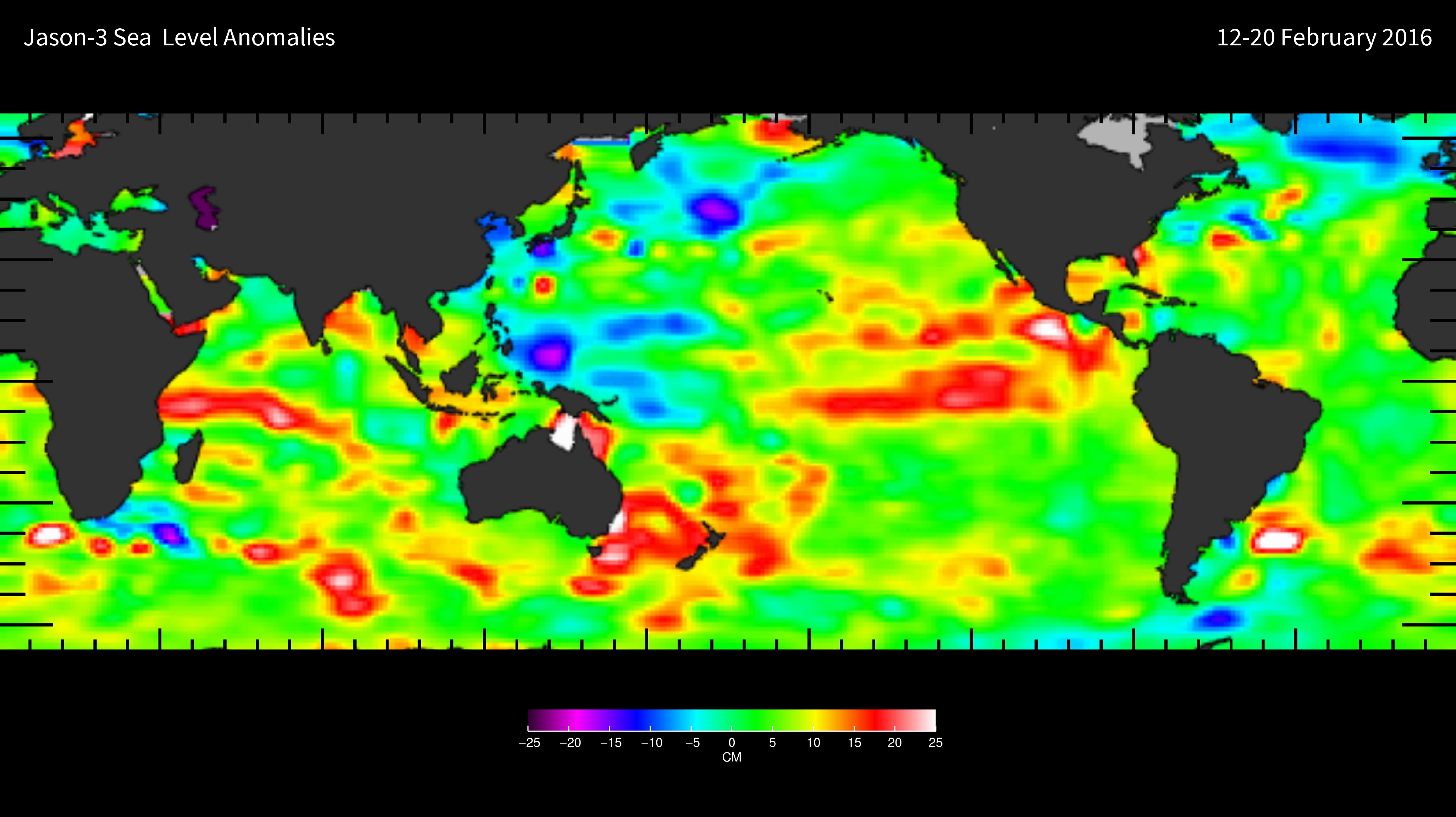
Aquarius Official Release Level 3 Rain-flagged Sea Surface Salinity Standard Mapped Image Descending Annual Data V5.0
National Aeronautics and Space Administration —
Aquarius Level 3 sea surface salinity (SSS) rain-flagged standard mapped image data contains gridded 1 degree spatial resolution SSS averaged over daily, 7 day,... -
Federal
[Lake Andes Wetland Management District: Aerial Photograph of Easement 22x in Hutchinson County, SD, 1983]
Department of the Interior —
This oblique aerial photograph from the Lake Andes Wetland Management District was taken from Easement 22x looking west in Hutchinson County, SD in November of 1988.... -
Federal
[Lake Andes Wetland Management District: Aerial Photograph of Cahalan WPA in Hand County, SD, 1967]
Department of the Interior —
This oblique aerial photograph from the Lake Andes Wetland Management District was taken from Cahalan WPA in Harding County, SD in 1967. The photograph shows two sets... -
Federal
[Lake Andes Wetland Management District: Aerial Photograph of Sullivan WPA in Miner County, SD, 1967]
Department of the Interior —
This oblique aerial photograph from the Lake Andes Wetland Management District shows Sullivan WPA in Miner County, SD in 1967. It is not intended for GIS use.

Official websites use .gov
A
.gov website belongs to an official government
organization in the United States.
Secure .gov websites use HTTPS
A
lock (
) or https:// means you’ve safely connected to
the .gov website. Share sensitive information only on official,
secure websites.