
-
Federal
GPM VIRS on TRMM unpacked data L1A 1.5 hours 2 km V07 (GPM_1AVIRS) at GES DISC
National Aeronautics and Space Administration —
This is the new (GPM-formated) TRMM product. It replaces the old TRMM_1A01 Version 07 is the current version of the data set. Previous versions have been superseded... -
Federal
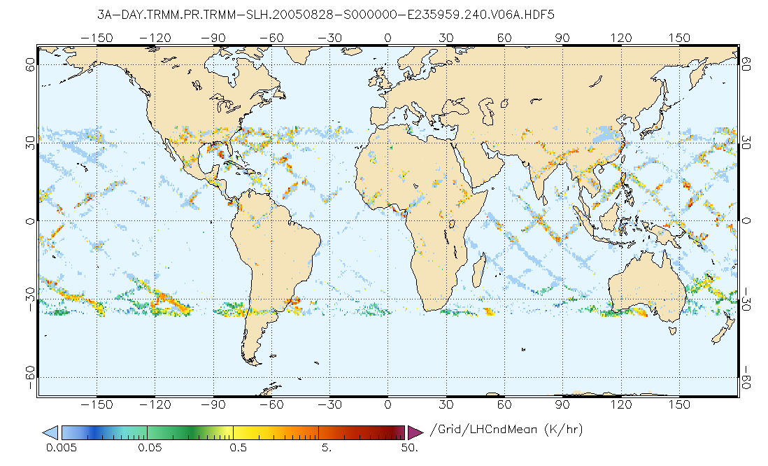
GPM PR on TRMM Spectral Latent Heating Profiles L3 1 Day 0.5x0.5 degree V07 (GPM_3HSLH_TRMM_DAY) at GES DISC
National Aeronautics and Space Administration —
This a new (GPM-formated) TRMM product. There is no equivalent in the old TRMM suite of products.Version 07 is the current version of the data set. Older versions... -
Federal
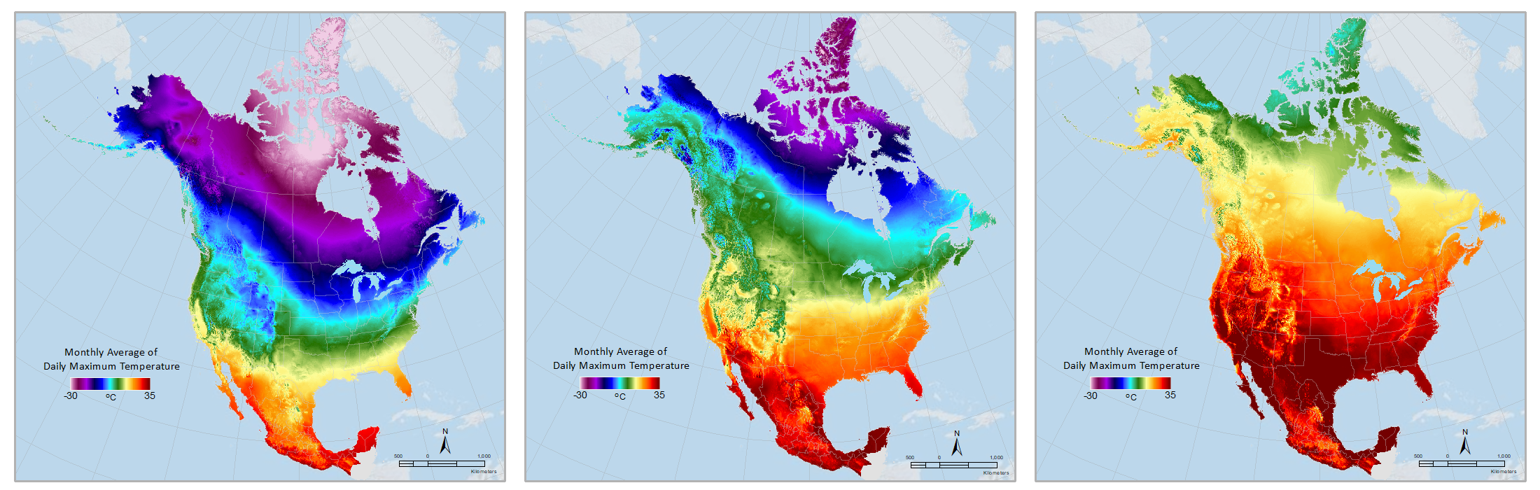
Daymet: Monthly Climate Summaries on a 1-km Grid for North America, Version 4 R1
National Aeronautics and Space Administration —
This dataset provides Daymet Version 4 R1 monthly climate summaries derived from Daymet Version 4 R1 daily data at a 1 km x 1 km spatial resolution for five Daymet... -
Federal
CERES A-Train Integrated CALIPSO, CloudSat, CERES, and MODIS (CCCM) Merged Release D1
National Aeronautics and Space Administration —
CER_CCCM_Aqua-FM3-MODIS-CAL-CS_RelD1 is the Clouds and the Earth's Radiant Energy System (CERES) A-Train Integrated Cloud-Aerosol Lidar and Infrared Pathfinder... -
Federal
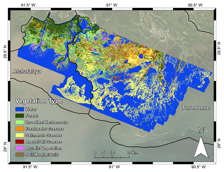
Delta-X AVIRIS-NG L3 Derived Vegetation Types, MRD, Louisiana, USA
National Aeronautics and Space Administration —
This dataset provides maps of vegetation types for the Atchafalaya and Terrebonne basins in coastal Louisiana, U.S., derived from NASA's Next Generation Airborne... -
Federal
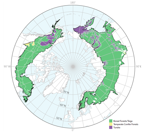
ABoVE: Tree Canopy Cover and Stand Age from Landsat, Boreal Forest Biome, 1984-2020
National Aeronautics and Space Administration —
This dataset contains Landsat-derived locally-calibrated estimates of tree canopy cover (TCC) and forest stand age across global boreal forests from 1984-2020 in... -
Federal
CALIPSO Infrared Imaging Radiometer (IIR) Level 2 Track, V4-20
National Aeronautics and Space Administration —
CAL_IIR_L2_Track-Standard-V4-20 is the Cloud-Aerosol Lidar and Infrared Pathfinder Satellite Observations (CALIPSO) Infrared Imaging Radiometer (IIR) Level 2 Track,... -
Federal
CALIPSO Infrared Imaging Radiometer (IIR) Level 2 Swath, V4-20
National Aeronautics and Space Administration —
CAL_IIR_L2_Swath-Standard-V4-20 is the Cloud-Aerosol Lidar and Infrared Pathfinder Satellite Observations (CALIPSO) Infrared Imaging Radiometer (IIR) Level 2 Swath,... -
Federal
BOREAS TF-08 NSA-OJP and SSA-OBS Ceilometer Data
National Aeronautics and Space Administration —
The BOREAS TF-08 team used ceilometers to collect data on the fraction of the sky covered with clouds and the cloud height. Included with these data is the surface-... -
Federal
CERES Monthly Gridded Single Satellite Fluxes and Clouds Aqua FM4 Edition2B
National Aeronautics and Space Administration —
CER_FSW_Aqua-FM4-MODIS_Edition2B is the Clouds and the Earth's Radiant Energy System (CERES) Fixed Swath Width (FSW) Monthly Gridded Single Satellite Fluxes (SSF) and... -
Federal
CERES MODIS Cloud Retrievals in ISCCP-D2like Format Day Terra FM1 Edition3A
National Aeronautics and Space Administration —
CER_ISCCP-D2like-Day_Terra-FM1-MODIS_Edition3A is the Clouds and the Earth's Radiant Energy System (CERES) Moderate Resolution Imaging Spectroradiometer (MODIS) Cloud... -
Federal
CALIPSO Lidar Level 3 Tropospheric Aerosol Profiles, Cloudy Sky Transparent Data, Standard V4-20
National Aeronautics and Space Administration —
CAL_LID_L3_Tropospheric_APro_CloudySkyTransparent-Standard-V4-20 is the Cloud-Aerosol Lidar and Infrared Pathfinder Satellite Observation (CALIPSO) Lidar Level 3... -
Federal
CERES Monthly Gridded Single Satellite Fluxes and Clouds Terra FM2 Edition2C
National Aeronautics and Space Administration —
CER_FSW_Terra-FM2-MODIS_Edition2C is the Clouds and the Earth's Radiant Energy System (CERES) Fixed Swath Width (FSW) Monthly Gridded Single Satellite Fluxes (SSF)... -
Federal
Sentinel-5P TROPOMI Ozone Profile 1-Orbit L2 30km x 30km V2 (S5P_L2__O3__PR_HiR) at GES DISC
National Aeronautics and Space Administration —
Starting from August 6th in 2019, Sentinel-5P TROPOMI along-track high spatial resolution (~5.5km at nadir) has been implemented. S5P_L2__O3__PR_HiR data collection... -
Federal
JERS-1 Synthetic Aperture Radar, 100-m Mosaics, South America: 1995-1996, R1
National Aeronautics and Space Administration —
This data set provides ~100-m resolution image mosaics of South America acquired during the low flood season between September and December 1995 and during the high... -
Federal
S-NPP CrIS IMG_COL: Array indices for collocated VIIRS observations V2 (SNDRSNCrISL1BIMGC) at GES DISC
National Aeronautics and Space Administration —
The Cross-track Infrared Sounder (CrIS) Level 1B Normal Spectral Resolution (NSR) data files contain radiance measurements along with ancillary spacecraft,...

Official websites use .gov
A
.gov website belongs to an official government
organization in the United States.
Secure .gov websites use HTTPS
A
lock (
) or https:// means you’ve safely connected to
the .gov website. Share sensitive information only on official,
secure websites.