
-
Federal
Impacts of Wildfires on Boreal Forest Ecosystem Carbon Dynamics recent views
National Aeronautics and Space Administration —
This dataset contains simulations of net primary production (NPP), heterotrophic respiration (RH), net ecosystem production (NEP), and soil temperature data in North... -
Federal
Global Forest Ecosystem Structure and Function Data For Carbon Balance Research recent views
National Aeronautics and Space Administration —
A comprehensive global database has been assembled to quantify CO2 fluxes and pathways across different levels of integration (from photosynthesis up to net ecosystem... -
Federal
Global Land Cover Characterization Program recent views
National Aeronautics and Space Administration —
The Global Land Cover Characterization Project was established to meet science data requirements identified by the International Geosphere and Biosphere Programme... -
Federal
MODIS/Terra+Aqua Direct Broadcast Burned Area Monthly L3 Global 500m SIN Grid V061 NGDA recent views
National Aeronautics and Space Administration —
The Terra and Aqua combined MCD64A1 Version 6.1 Burned Area data product is a monthly, global gridded 500 meter (m) product containing per-pixel burned-area and... -
Federal
USGS Digital Orthophoto Quadrangles recent views
National Aeronautics and Space Administration —
A Digital Orthophoto Quadrangle (DOQ) is a computer-generated image of an aerial photograph in which the image displacement caused by terrain relief and camera tilt... -
Federal
USGS Global Forest Observations Initiative (GFOI) Guatemala recent views
National Aeronautics and Space Administration —
The Global Forest Observations Initiative (GFOI) is an initiative of the inter-governmental Group on Earth Observations (GEO) that aims to: foster the sustained... -
Federal
Sentinel-3A OLCI Global Mapped CyAN Project, True Color (TC) - Near Real-Time (NRT) Data, version 5.0 recent views
National Aeronautics and Space Administration —
The Ocean Biology DAAC produces near real-time (quicklook) products using the best-available combination of ancillary data from meteorological and ozone data. As... -
Federal
Sentinel-3B OLCI Global Mapped CyAN Project, True Color (TC) - Near Real-Time (NRT) Data, version 5.0 recent views
National Aeronautics and Space Administration —
The Ocean Biology DAAC produces near real-time (quicklook) products using the best-available combination of ancillary data from meteorological and ozone data. As... -
Federal
Net Radiation and Albedo from MODIS for Xingu River Basin, Brazil, 2000-2012 NGDA recent views
National Aeronautics and Space Administration —
This dataset provides daily average land surface net radiation (Rnet) as an 8-day time series at approximately 0.5 km resolution for the upper Xingu River Basin in... -
Federal
Local Observations from the Seasonal Ice Zone Observing Network (SIZONet) and Alaska Arctic Observatory and Knowledge Hub (AAOKH), Version 2 recent views
National Aeronautics and Space Administration —
The Seasonal Ice Zone Observing Network (SIZONet) and the Alaska Arctic Observatory and Knowledge Hub (AAOKH) share the Local Observations Interface, which allows... -
Federal
Arctic Boreal Annual Burned Area, Circumpolar Boreal Forest and Tundra, V2, 2002-2022 NGDA recent views
National Aeronautics and Space Administration —
This dataset provides annual cumulative end-of-season burned area in circumpolar boreal forests and tundra for the years 2002-2022. The data were generated using the... -
Federal
SAR Subsets for Selected Field Sites, 2007-2010 recent views
National Aeronautics and Space Administration —
This data set provides Synthetic Aperture Radar (SAR) images for 42 selected sites from various terrestrial ecology and meteorological monitoring networks including... -
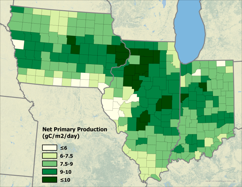
Federal
Ecosys Model-Estimated Cropland Carbon Fluxes, Illinois, Indiana, and Iowa, 2001-2018 recent views
National Aeronautics and Space Administration —
This dataset contains daily estimates of carbon fluxes in croplands derived from the "ecosys" model covering a portion of the Midwestern US (Illinois, Indiana, and... -
Federal
Merged Sentinel-3A and Sentinel-3B OLCI Global Mapped Cyanobacteria Index (CI) - Near Real-time (NRT) Data, version 5.0 recent views
National Aeronautics and Space Administration —
The Ocean Biology DAAC produces near real-time (quicklook) products using the best-available combination of ancillary data from meteorological and ozone data. As... -
Federal
ABoVE: Peak Greenness for Canadian Boreal Forest from Landsat 5 TM Imagery, 1984-2011 recent views
National Aeronautics and Space Administration —
This dataset provides a 28-year time series of peak greenness (NDVI) data derived from Landsat 5 TM imagery over the boreal forest region of Canada. Landsat 5 TM... -
Federal
USGS Global Forest Observations Initiative (GFOI) Costa Rica recent views
National Aeronautics and Space Administration —
The Global Forest Observations Initiative (GFOI) is an initiative of the inter-governmental Group on Earth Observations (GEO) that aims to: foster the sustained... -
Federal
Alaska's Changing YK Delta: Knowledge Exchange between Elders and Geoscientists, 2018 recent views
National Aeronautics and Space Administration —
This dataset provides a booklet documenting the discussions and outcomes from a knowledge-exchange meeting with Yup'ik elders from the Yukon-Kuskokwim Delta (YKD),... -
Federal
SAFARI 2000 Historical Fire Maps, Kruger National Park, 1992-2001 recent views
National Aeronautics and Space Administration —
Kruger National Park (KNP) was established in 1898 to protect wildlife on nearly 2 million hectares of the South African Lowveld. Savanna fires are common in the... -
Federal
ABoVE: Characterization of Carbon Dynamics in Burned Forest Plots, NWT, Canada, 2014 recent views
National Aeronautics and Space Administration —
This dataset provides field data from boreal forests in the Northwest Territories (NWT), Canada, that were burned by wildfires in 2014. During fieldwork in 2015, 211... -
Federal
SAFARI 2000 Global Burned Area Map, 1-km, Southern Africa, 2000 recent views
National Aeronautics and Space Administration —
The Global Burned Area 2000 initiative (GBA2000) was launched by the Global Vegetation Mapping Unit of the Joint Research Centre of the European Commission, in...

Official websites use .gov
A
.gov website belongs to an official government
organization in the United States.
Secure .gov websites use HTTPS
A
lock (
) or https:// means you’ve safely connected to
the .gov website. Share sensitive information only on official,
secure websites.