
-
County
Redlining Maps from the Home Owners Loan Corporation, 1937 recent views
Allegheny County / City of Pittsburgh / Western PA Regional Data Center —
Most of the text in this description originally appeared on the Mapping Inequality Website. Robert K. Nelson, LaDale Winling, Richard Marciano, Nathan Connolly, et... -
County
LEGO Diorama Images recent views
Allegheny County / City of Pittsburgh / Western PA Regional Data Center —
We often create dioramas from LEGO bricks for use with our presentations, blogs, and social media posts. We find it's much more fun and effective to reenact meetings... -
Federal
Poverty Mapping Project: Poverty and Food Security Case Studies recent views
National Aeronautics and Space Administration —
The Poverty Mapping Project: Poverty and Food Security Case Studies data set consists of small area estimates of poverty, inequality, food security and related... -
Federal
Poverty Mapping Project: Global Subnational Prevalence of Child Malnutrition recent views
National Aeronautics and Space Administration —
The Poverty Mapping Project: Global Subnational Prevalence of Child Malnutrition data set consists of estimates of the percentage of children with weight-for-age... -
Federal
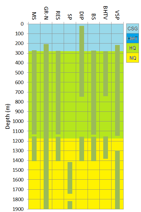
Newberry EGS Demonstration: Well 55-29 Stimulation Data recent views
Department of Energy —
The Newberry Volcano EGS Demonstration in central Oregon, a 3 year project started in 2010, tests recent technological advances designed to reduce the cost of power... -
Federal
OMPS-NPP L1G LP Radiance EV Wavelength-Altitude Grid swath orbital 3slit V2.6 (OMPS_NPP_LP_L1G_EV) at GES DISC recent views
National Aeronautics and Space Administration —
The OMPS-NPP L1G LP Radiance EV Wavelength-Altitude Grid swath orbital 3slit product contains the calibrated earth-viewing radiances measured by the Ozone Mapping and... -
Federal
CYGNSS Level 3 MRG Science Data Record Near Real Time Version 3.2.1 recent views
National Aeronautics and Space Administration —
This dataset contains the version 3.2.1 CYGNSS Level 3 Merged (MRG) Science Data Record Near Real Time (NRT) Storm Wind Speed derived from the Delay Doppler Mapping... -
Federal
Aquarius Official Release Level 3 Sea Surface Salinity Standard Mapped Image Descending Daily Data V5.0 recent views
National Aeronautics and Space Administration —
Aquarius Level 3 sea surface salinity (SSS) standard mapped image data contains gridded 1 degree spatial resolution SSS averaged over daily, 7 day, monthly, and... -
Federal
Project HOTSPOT: Kimama Well Borehole Geophysics Database recent views
Department of Energy —
The Snake River Plain (SRP), Idaho, hosts potential geothermal resources due to elevated groundwater temperatures associated with the thermal anomaly Yellowstone-... -
Federal
H11722: NOS Hydrographic Survey , Approaches to Willmington, North Carolina, 2007-06-26 recent views
National Oceanic and Atmospheric Administration, Department of Commerce —
The National Oceanic and Atmospheric Administration (NOAA) has the statutory mandate to collect hydrographic data in support of nautical chart compilation for safe... -
Federal
Upper Cliff Dwelling Scans 2022 recent views
Department of the Interior —
Laser scan point cloud collected in April 2022 at the Upper Cliff Dwelling of Tonto National Monument using a FARO x330 laser scanner. Registered to legacy 2005 data... -
Federal
GHRSST NOAA/STAR GOES-17 ABI L3C America Region SST v2.71 dataset in GDS2 recent views
National Aeronautics and Space Administration —
The ACSPO G17/ABI L3C (Level 3 Collated) product is a gridded version of the ACSPO G17/ABI L2P product available at... -
Federal
Aquarius Official Release Level 3 Sea Surface Spiciness Standard Mapped Image Ascending 28-Day Running Mean Data V5.0 recent views
National Aeronautics and Space Administration —
Aquarius Level 3 sea surface salinity spiciness standard mapped image data contains gridded 1 degree spatial resolution spice data averaged over daily, 7 day,... -
Federal
MuSLI Multi-Source Land Surface Phenology Yearly North America 30 m V011 recent views
National Aeronautics and Space Administration —
The Multi-Source Land Surface Phenology (LSP) Yearly North America 30 meter (m) Version 1.1 product (MSLSP) provides a Land Surface Phenology product for North... -
Federal
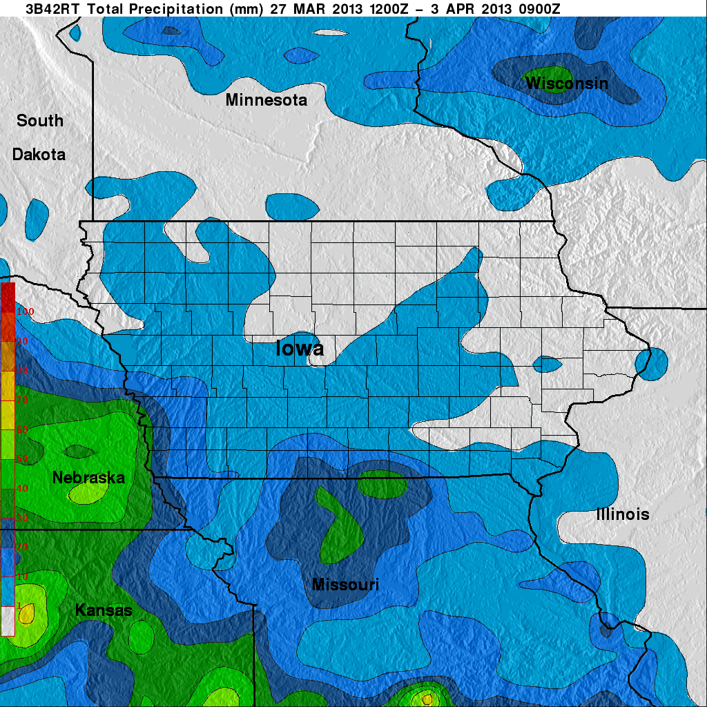
GPM Ground Validation Global Flood Monitoring System (GFMS) Flood Maps IFloodS V1 recent views
National Aeronautics and Space Administration —
The GPM Ground Validation Global Flood Monitoring System (GFMS) Flood Maps IFloodS dataset contains global flood estimates on a 0.25 degree spatial resolution every 3... -
Federal
Sentinel-6A MF Jason-CS L2 P4 Altimeter Low Resolution (LR) NTC Reduced Ocean Surface Topography F08 recent views
National Aeronautics and Space Administration —
Provides low resolution (LR) non-time critical (NTC; 60-day latency) measurements of sea surface height anomaly (SSHA), Significant Wave Height (SWH), and Wind Speed.... -
State
DWR Airborne Electromagnetic (AEM) Surveys Data recent views
State of California —
Statewide AEM Surveys Project Overview The Department of Water Resources’ (DWR’s) Statewide Airborne Electromagnetic (AEM) Surveys Project is funded through... -
Federal
H10625: NOS Hydrographic Survey , Vineyard Sound and Long Island Sound, New York, 1995-11-18 recent views
National Oceanic and Atmospheric Administration, Department of Commerce —
The National Oceanic and Atmospheric Administration (NOAA) has the statutory mandate to collect hydrographic data in support of nautical chart compilation for safe... -
Federal
H11416: NOS Hydrographic Survey , Brunswick, Georgia, 2006-09-26 recent views
National Oceanic and Atmospheric Administration, Department of Commerce —
The National Oceanic and Atmospheric Administration (NOAA) has the statutory mandate to collect hydrographic data in support of nautical chart compilation for safe...

Official websites use .gov
A
.gov website belongs to an official government
organization in the United States.
Secure .gov websites use HTTPS
A
lock (
) or https:// means you’ve safely connected to
the .gov website. Share sensitive information only on official,
secure websites.
.jpg)
.jpg)
.jpg)