
-
Federal
GLDAS Noah Land Surface Model L4 monthly 0.25 x 0.25 degree V2.1 (GLDAS_NOAH025_M) at GES DISC
National Aeronautics and Space Administration —
NASA Global Land Data Assimilation System Version 2 (GLDAS-2) has three components: GLDAS-2.0, GLDAS-2.1, and GLDAS-2.2. GLDAS-2.0 is forced entirely with the... -
Federal
Characterization Factors for Construction Material EPD Indicators (ISO21930-LCIA-US) v0.1
U.S. Environmental Protection Agency —
This dataset contains characterization factors (CFs) for the five mandatory life cycle impact assessment (LCIA) categories required in ISO 21930:2017: 1. Greenhouse... -
Federal
Microgrid Load and LCOE Modelling Results
Department of Energy —
These tools are designed to inform high level thinking around micro-grid load and tariff considerations in sub-Saharan Africa. There are two related tools in this... -
Federal
GLDAS Catchment Land Surface Model L4 daily 0.25 x 0.25 degree GRACE-DA1 V2.2 (GLDAS_CLSM025_DA1_D_EP) at GES DISC
National Aeronautics and Space Administration —
NASA Global Land Data Assimilation System Version 2 (GLDAS-2) has three components: GLDAS-2.0, GLDAS-2.1, and GLDAS-2.2. GLDAS-2.0 is forced entirely with the... -
Federal
TOLNet NASA Langley Research Center Data
National Aeronautics and Space Administration —
TOLNet_LaRC_Data is the lidar data collected by the Langley Mobile Ozone Lidar (LMOL) at NASA Langley Research Center (LaRC) as part of the Tropospheric Ozone Lidar... -
Federal
VIIRS/NPP BRDF/Albedo Quality Daily L3 Global 500m SIN Grid V001
National Aeronautics and Space Administration —
The VNP43IA2 Version 1 data product was decommissioned on July 31, 2025. Users are encouraged to use the VNP43IA2 and VJ143IA2 Version 2 data products.The NASA/NOAA... -
Federal
HLS Landsat Operational Land Imager Surface Reflectance and TOA Brightness Daily Global 30m v2.0
National Aeronautics and Space Administration —
The Harmonized Landsat Sentinel-2 (HLS) project provides consistent surface reflectance (SR) and top of atmosphere (TOA) brightness data from a virtual constellation... -
Federal
MODIS/Aqua Surface Reflectance Quality Daily L2G Global 1km SIN Grid NRT
National Aeronautics and Space Administration —
The MODIS/Aqua Surface Reflectance Quality Daily L2G Global 1km SIN Grid Near Real Time (NRT) product, short name MYD09GST, is a restructured version of its primary... -
Federal
CAMP2Ex Learjet In-Situ Aerosol Data
National Aeronautics and Space Administration —
CAMP2Ex_Aerosol_AircraftInSitu_Learjet_Data are in-situ aerosol measurements conducted onboard the SPEC Learjet aircraft during the Clouds, Aerosol and Monsoon... -
Federal
Leaf Area Index Maps at 30-m Resolution, VALERI Site, Larose, Canada
National Aeronautics and Space Administration —
This data set provide local LAI maps for the Larose (Ontario) site in Canada. These derived maps may also be useful for validating other LAI maps over this same site... -
Federal
TOLNet Environment and Climate Change Canada Data
National Aeronautics and Space Administration —
TOLNet_ECCC_Data is the lidar data collected by the Autonomous Mobile Ozone LIDAR instrument for Tropospheric Experiments (AMOLITE) lidar at Environment and Climate... -
Federal
Sounder SIPS: Suomi NPP CrIMSS Level 3 Specific Quality Control Gridded Daily CHART Normal Spectral Resolution V1
National Aeronautics and Space Administration —
The objective of this limited edition data collection is to examine products generated by the Climate Heritage AIRS Retrieval Technique (CHART) algorithm to analyze... -
Federal
First ISCCP Regional Experiment (FIRE) Cirrus Phase II National Weather Service(NWS) Inner-Network Rawinsonde Data
National Aeronautics and Space Administration —
The First ISCCP Regional Experiments have been designed to improve data products and cloud/radiation parameterizations used in general circulation models (GCMs).... -
Federal
TOLNet NASA Jet Propulsion Laboratory Data
National Aeronautics and Space Administration —
TOLNet_JPL_Data are lidar data collected by several ozone Differential Absorption Lidar instruments developed at the NASA Jet Propulsion Laboratory Table Mountain... -
Federal
GLDAS Noah Land Surface Model L4 monthly 0.25 x 0.25 degree Early Product V2.1 (GLDAS_NOAH025_M_EP) at GES DISC
National Aeronautics and Space Administration —
NASA Global Land Data Assimilation System Version 2 (GLDAS-2) has three components: GLDAS-2.0, GLDAS-2.1, and GLDAS-2.2. GLDAS-2.0 is forced entirely with the... -
Federal
VIIRS/NPP BRDF/Albedo Nadir BRDF-Adjusted Ref Daily L3 Global 500m SIN Grid V002
National Aeronautics and Space Administration —
The NASA/NOAA Suomi National Polar-orbiting Partnership (Suomi NPP) Visible Infrared Imaging Radiometer Suite (VIIRS) Nadir Bidirectional Reflectance Distribution... -
Federal
VIIRS/NPP BRDF/Albedo Albedo Daily L3 Global 500m SIN Grid V002
National Aeronautics and Space Administration —
The VNP43IA3 Version 1 data product was decommissioned on July 31, 2025. Users are encouraged to use the VNP43IA3 and VJ143IA3 Version 2 data products.The NASA/NOAA... -
Federal
TOLNet NOAA Chemical Sciences Laboratory Data
National Aeronautics and Space Administration —
TOLNet_CSL_Data is the lidar data collected by the Tunable Optical Profile for Aerosol and oZone (TOPAZ) lidar at the NOAA Chemical Sciences Laboratory (CSL) in... -
Federal
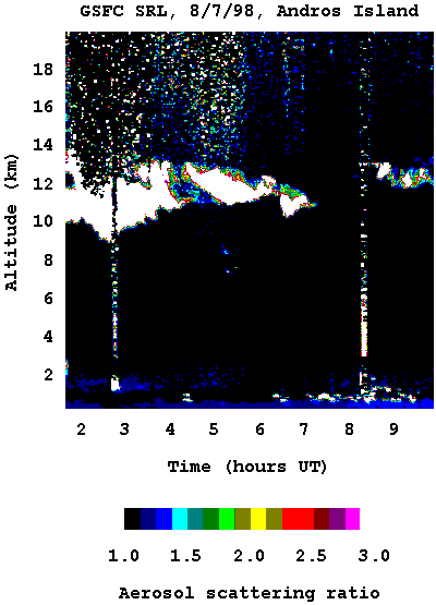
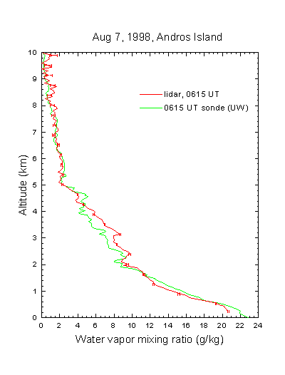
CAMEX-3 SCANNING RAMAN LIDAR V1
National Aeronautics and Space Administration —
The CAMEX-3 Scanning Raman LIDAR dataset collected data during the CAMEX-3 campaign on Andros Island during the period 6 August - 20 September 1998. The SRL... -
Federal
BOREAS RSS-18 Level 1B AVIRIS At-Sensor Radiance Imagery
National Aeronautics and Space Administration —
This dataset holds Level 1B (L1B) radiance data collected by the AVIRIS-Classic instrument near Prince Albert, Saskatchewan, Canada, on August 14, 1996. This imagery...

Official websites use .gov
A
.gov website belongs to an official government
organization in the United States.
Secure .gov websites use HTTPS
A
lock (
) or https:// means you’ve safely connected to
the .gov website. Share sensitive information only on official,
secure websites.