
-
Federal
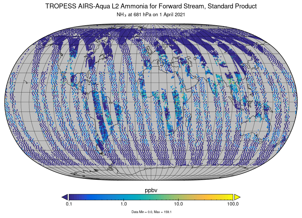
TROPESS AIRS-Aqua L2 Ammonia for Forward Stream, Standard Product V1 (TRPSDL2NH3AIRSFS) at GES DISC recent views
National Aeronautics and Space Administration —
The TROPESS AIRS-Aqua L2 Ammonia for Forward Stream, Standard Product contains the vertical distribution of the retrieved atmospheric state of ammonia (NH3), formal... -
Federal
FLDAS Noah Land Surface Model L4 Global Monthly Anomaly 0.1 x 0.1 degree (MERRA-2 and CHIRPS) V001 (FLDAS_NOAH01_C_GL_MA) at GES DISC recent views
National Aeronautics and Space Administration —
The monthly anomaly data set contains a series of land surface parameters simulated from the Noah 3.6.1 model in the Famine Early Warning Systems Network (FEWS NET)... -
Federal
MODIS Aqua L2 chopped blocks (block size: 128 pixels x 128 pixels, daytime) V001 (MYD_L2_CB) at GES DISC NGDA recent views
National Aeronautics and Space Administration —
This product is composed of a beta version for a product from the MODerate resolution Imaging Spectrometer (MODIS) on board the Aqua satellite. MODIS Aqua L2 chopped... -
Federal
NOAA/WDS Paleoclimatology - Swetnam fire data from Langstroth Mesa - IMPD USLNG001 recent views
National Oceanic and Atmospheric Administration, Department of Commerce —
This archived Paleoclimatology Study is available from the NOAA National Centers for Environmental Information (NCEI), under the World Data Service (WDS) for... -
Federal
CMS: Modeled Net Ecosystem Exchange at 3-hourly Time Steps, 2004-2010 recent views
National Aeronautics and Space Administration —
This data set provides global, gridded, model-derived net ecosystem exchange (NEE) of CO2 flux between the land and atmosphere at 3-hourly time steps over seven years... -
Federal
CARVE: L2 Column Gas and Uncertainty from Airborne FTS, Alaska, 2012-2015 recent views
National Aeronautics and Space Administration —
This data set provides total vertical column O2, CO2, CH4, CO, and H2O, as well as dry-air columns of CO2, CH4, CO, and H2O from airborne campaigns over the Alaskan... -
Federal
CARVE: L1 Daily Flight Path Geolocation and Aircraft Position Data, Alaska, 2012-2015 recent views
National Aeronautics and Space Administration —
This data set provides high-frequency geolocation, time, height, pitch, roll, and heading information for the C-23 Sherpa aircraft during airborne campaigns over the... -
Federal
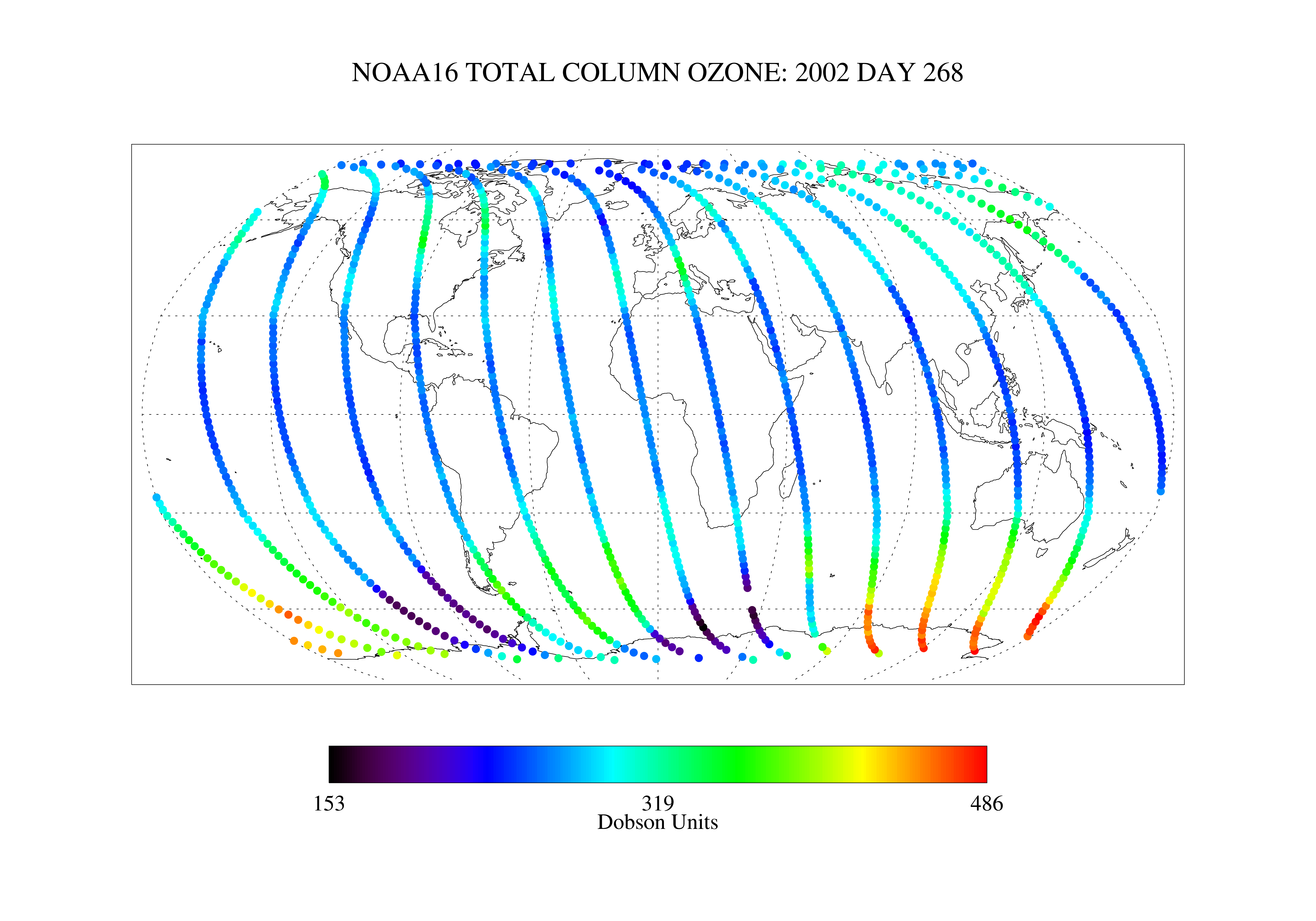
SBUV2/NOAA-16 Ozone (O3) Nadir Profile and Total Column 1 Day L2 V1 (SBUV2N16L2) at GES DISC recent views
National Aeronautics and Space Administration —
The Solar Backscattered Ultraviolet (SBUV) from NOAA-16 Level-2 daily product (SBUV2N16L2) contains ozone nadir profile and total column data from retrievals... -
Federal
TIROS-4 Medium-Resolution Scanning Radiometer Level 1 Final Meteorological Radiation Data V001 (TIROS4L1FMRT) at GES DISC recent views
National Aeronautics and Space Administration —
TIROS-4 Medium-Resolution Scanning Radiometer Level 1 Final Meteorological Radiation Data (FMRT) product contains radiances expressed in five infrared/visible... -
Federal
NOAA/WDS Paleoclimatology - Heyerdahl fire data from Henry Mountains - IMPD USHNR001 recent views
National Oceanic and Atmospheric Administration, Department of Commerce —
This archived Paleoclimatology Study is available from the NOAA National Centers for Environmental Information (NCEI), under the World Data Service (WDS) for... -
Federal
ABoVE: Annual Thaw Slump Expansion on East Fork Chandalar River, Alaska, 2008-2017 recent views
National Aeronautics and Space Administration —
This dataset provides a time series of spatial data showing the expansion of a thaw slump on the East Fork Chandalar River near the community of Venetie, Alaska, from... -
Federal
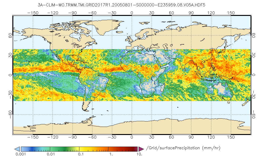
GPM TMI on TRMM (GPROF) Climate-based Radiometer Precipitation Profiling L3 1 month 0.25 degree x 0.25 degree V07 (GPM_3GPROFTRMMTMI_CLIM) at GES DISC recent views
National Aeronautics and Space Administration —
This is the new (GPM-formated) TRMM product. It replaces the old TRMM_3A12,3A11 Version 07 is the current version of the data set. Older versions will no longer be... -
Federal
GPM PR on TRMM Reflectivity, Precipitation Characteristics and Rate, at Surface and Profile L2 1.5 hours V07 (GPM_2APR) at GES DISC recent views
National Aeronautics and Space Administration —
This is the new, GPM-like, format for TRMM Precipitation Radar L2 data that now incorporates what was known as 2A21, 2A23 and 2A25 datasets. The primary purpose of... -
Federal
NOAA/WDS Paleoclimatology - Johnson fire data from Yerba Canyon, northern New Mexico - IMPD USYER001 recent views
National Oceanic and Atmospheric Administration, Department of Commerce —
This archived Paleoclimatology Study is available from the NOAA National Centers for Environmental Information (NCEI), under the World Data Service (WDS) for... -
Federal
THIR/Nimbus-7 Level 1 Cloud Data for SBUV/TOMS V001 (THIRN7L1BCLT) at GES DISC recent views
National Aeronautics and Space Administration —
THIRN7L1BCLT is the Nimbus-7 Temperature-Humidity Infrared Radiometer (THIR) Level 1 Cloud Data for SBUV/TOMS (BCLT) product and contains total cloud amounts;... -
Federal
Arctic Vegetation Plots at Happy Valley, Alaska, 1994 recent views
National Aeronautics and Space Administration —
This dataset provides environmental, soil, and vegetation data collected in July 1994 from 56 study plots at the Happy Valley research site, located along the... -
Federal
Gridded GEDI-Fusion Forest Structure Metrics across Six Western US States, 2016-2020 recent views
National Aeronautics and Space Administration —
This dataset provides eight GEDI forest structure metrics relevant to wildlife habitat modeling and biodiversity assessments at 30-m resolutions across Washington,... -
Federal
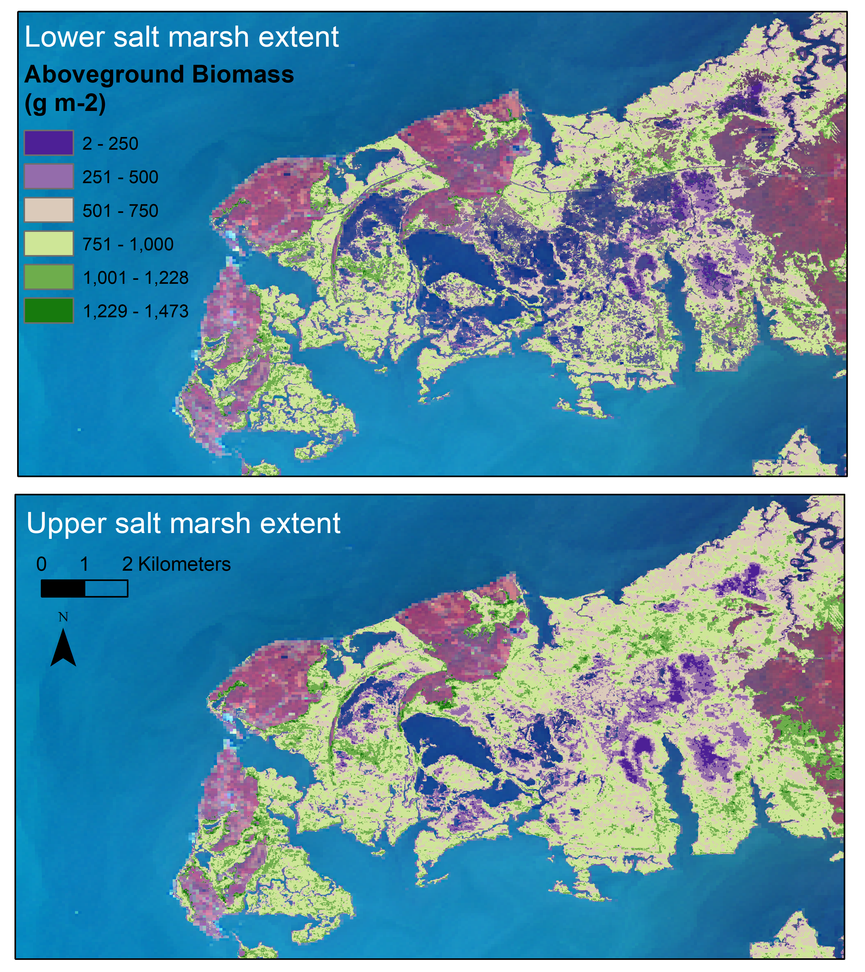
Aboveground Biomass Estimates for Salt Marsh for the Contiguous United States, 2020 recent views
National Aeronautics and Space Administration —
This dataset provides estimates of aboveground biomass (AGB) and salt marsh extent in the contiguous United States for 2020 and includes all coastal watersheds across... -
Federal
NOAA/WDS Paleoclimatology - Heyerdahl fire data from Sheafman Creek - IMPD USSHE001 recent views
National Oceanic and Atmospheric Administration, Department of Commerce —
This archived Paleoclimatology Study is available from the NOAA National Centers for Environmental Information (NCEI), under the World Data Service (WDS) for... -
Federal
Bowen Ratio Surface Flux: KSU (FIFE) recent views
National Aeronautics and Space Administration —
Assessing the effects of annual burning & topography on surface energy exchanges

Official websites use .gov
A
.gov website belongs to an official government
organization in the United States.
Secure .gov websites use HTTPS
A
lock (
) or https:// means you’ve safely connected to
the .gov website. Share sensitive information only on official,
secure websites.