
-
Federal
CYGNSS L3 Ocean Microplastic Concentration V1.0
National Aeronautics and Space Administration —
This dataset contains the version 1.0 CYGNSS level 3 ocean microplastic concentration data record, which provides 18 netCDF files, each containing one month of daily... -
Federal
MetOp-C ASCAT Level 2 25.0km Ocean Surface Wind Vectors in Full Orbit Swath
National Aeronautics and Space Administration —
This dataset contains operational near-real-time Level 2 ocean surface wind vector retrievals from the Advanced Scatterometer (ASCAT) on MetOp-C at 25 km sampling... -
Federal
MetOp-C ASCAT Level 2 Ocean Surface Wind Vectors Optimized for Coastal Ocean
National Aeronautics and Space Administration —
This dataset contains operational near-real-time Level 2 coastal ocean surface wind vector retrievals from the Advanced Scatterometer (ASCAT) on MetOp-C at 12.5 km... -
Federal
GHRSST Level 3U Global Subskin Sea Surface Temperature version 8a from the Advanced Microwave Scanning Radiometer 2 on the GCOM-W satellite
National Aeronautics and Space Administration —
GDS2 Version -The Advanced Microwave Scanning Radiometer 2 (AMSR2) was launched on 18 May 2012, onboard the Golbal Change Observation Mission - Water (GCOM-W)... -
Federal
Aquarius Official Release Level 3 Wind Speed Standard Mapped Image Ascending Seasonal Climatology Data V5.0
National Aeronautics and Space Administration —
Aquarius Level 3 ocean surface wind speed standard mapped image data contains gridded 1 degree spatial resolution wind speed data averaged over daily, 7 day, monthly,... -
Federal
SWOT Level 2 Nadir Altimeter Geophysical Data Record with Waveforms - GDR Version D
National Aeronautics and Space Administration —
The SWOT Level 2 Nadir Altimeter Geophysical Data Record (GDR) with Waveforms dataset produced by the Surface Water and Ocean Topography (SWOT) mission provides sea... -
Federal
SWOT Level 2 KaRIn Low Rate Sea Surface Height Data Product - Unsmoothed, Version 2.0
National Aeronautics and Space Administration —
The SWOT Level 2 KaRIn Low Rate Sea Surface Height Unsmoothed Data Product from the Surface Water Ocean Topography (SWOT) mission provides global sea surface height... -
Federal
RSS SMAP Level 2C Sea Surface Salinity NRT V6.0 Validated Dataset
National Aeronautics and Space Administration —
The SMAP-SSS level 2C near real-time (NRT) V6.0 dataset produced by the Remote Sensing Systems (RSS) and sponsored by the NASA Ocean Salinity Science Team, is a... -
Federal
Sentinel-6A MF Jason-CS L2 Advanced Microwave Radiometer (AMR-C) STC Geophysical Parameters
National Aeronautics and Space Administration —
Provides L2 short time critical (STC; 36-hour latency) geophysical information from the Advanced Microwave Radiometer on the Sentinel-6A Michael Freilich spacecraft... -
Federal
MetOp-B ASCAT Level 2 Ocean Surface Wind Vectors Optimized for Coastal Ocean
National Aeronautics and Space Administration —
This dataset contains operational near-real-time Level 2 coastal ocean surface wind vector retrievals from the Advanced Scatterometer (ASCAT) on MetOp-B at 12.5 km... -
Federal
CYGNSS Level 1 Science Data Record Version 3.2
National Aeronautics and Space Administration —
This CYGNSS Level 1 (L1) science data record dataset contains the version 3.2 geo-located Delay Doppler Maps (DDMs) calibrated into Power Received (Watts) and... -
Federal
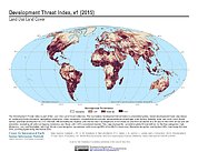
Development Threat Index
National Aeronautics and Space Administration —
The Development Threat Index data set is a terrestrial global, future development threat map based on combining these resources: agricultural expansion, urban... -
Federal
MetOp-A ASCAT Level 2 12.5-km Ocean Surface Wind Vector Climate Data Record Optimized for Coastal Ocean
National Aeronautics and Space Administration —
This dataset represents the first historically reprocessed Level 2 coastal ocean surface wind vector climate data record from the Advanced Scatterometer (ASCAT) on... -
Federal
Daily Soil Temperature and Meteorological Data for Sites at Toolik Lake Alaska, Version 1
National Aeronautics and Space Administration —
This data set consists of daily air, water, and soil temperature, wind speed, vapor pressure, and the sum of global radiation and unfrozen precipitation data from the... -
Federal
Eole 1 Raw Temperature, Pressure and Location Data Near 200 mbar (EOLE1) at GES DISC
National Aeronautics and Space Administration —
The Eole 1 Raw Temperature, Pressure and Location Data Near 200 mbar product was obtained from the experimenter and originally consisted of a BCD tape generated on a... -
Federal
JPL SMAP Level 2B Near Real-time CAP Sea Surface Salinity V5.0 Validated Dataset
National Aeronautics and Space Administration —
This is the PI-produced JPL SMAP-SSS V5.0, level 2B NRT CAP, validated sea surface salinity (SSS) and extreme winds orbital/swath product from the NASA Soil Moisture... -
Federal
SWOT Level 2 Radiometer Brightness Temperatures and Troposphere Operational Data Product, Version 2.0
National Aeronautics and Space Administration —
The SWOT Level 2 Radiometer Brightness Temperatures and Troposphere Operational Geophysical Data Record (OGDR) Version 1.0 dataset produced by the Surface Water and... -
Federal
Metop-B ASCAT Inter-Calibrated ESDR Level 2 Observed and Modeled Spatial Derivatives of Surface Wind and Wind Stress Version 1.0
National Aeronautics and Space Administration —
This dataset contains the curl and divergence of ocean surface equivalent neutral wind and wind stress, derived from satellite-based scatterometer observations (the... -
Federal
SPURS-2 Central mooring CTD, surface flux and meterorological data for the E. Tropical Pacific field campaign
National Aeronautics and Space Administration —
The SPURS (Salinity Processes in the Upper Ocean Regional Study) project is NASA-funded oceanographic process study and associated field program that aim to elucidate...

Official websites use .gov
A
.gov website belongs to an official government
organization in the United States.
Secure .gov websites use HTTPS
A
lock (
) or https:// means you’ve safely connected to
the .gov website. Share sensitive information only on official,
secure websites.